Table Top, New South Wales
| Table Top Albury, New South Wales | |||||||||||||
|---|---|---|---|---|---|---|---|---|---|---|---|---|---|
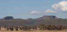 Table Top Mountain | |||||||||||||
|
Table Top | |||||||||||||
| Coordinates | 35°59′0″S 147°0′0″E / 35.98333°S 147.00000°ECoordinates: 35°59′0″S 147°0′0″E / 35.98333°S 147.00000°E | ||||||||||||
| Population | 1,253 (2011 census)[1] | ||||||||||||
| Postcode(s) | 2640 | ||||||||||||
| Location | |||||||||||||
| LGA(s) | City of Albury | ||||||||||||
| State electorate(s) | Albury | ||||||||||||
| Federal Division(s) | Farrer | ||||||||||||
| |||||||||||||
Table Top is an outer suburb of the city of Albury, New South Wales, located 16 kilometres (10 mi) north of Albury and 19 kilometres (12 mi) west of Bowna. At the 2011 census, Table Top had a population of 1253.[1] The area used to be part of the Greater Hume Shire but was recently integrated into the City of Albury.
Table Top is located in the flat area north of Albury, bounded by the Greater Hume Shire, including Jindera, to the north, and the suburbs of Hamilton Valley, Springdale Heights, Thurgoona and Wirlinga to the south.
History
Yambla Post Office opened on 1 April 1886, was renamed Table Top in 1895 and closed in 1968.[2]
Today
Table Top is a rural and agricultural area, with a large part of the population living in an area around the Norske Skog Paper Mill. Features of the area include the original Ettamogah Pub (based on a cartoon pub by Ken Maynard that was featured in the now defunct Australasian Post magazine), the Ettamogah Wildlife Sanctuary (now called Oze Wildlife)(now closed), several wineries and Table Top Public School.
Geography

The Table Top area is mostly flat, but includes part of the Black Range in the south and east. Part of the area is the north-western part of Lake Hume.
Residents

At the 2006 Census, the population of Table Top/Ettamogah was 1179. The most common religion was Catholic, followed by Anglican, and the average household income was $1381, above the Australian average of $1027. The median age was 37.
References
- 1 2 Australian Bureau of Statistics (31 October 2012). "Table Top (State Suburb)". 2011 Census QuickStats. Retrieved 2016-10-05.
- ↑ Premier Postal History, Post Office List, retrieved 2009-06-11