Tai Mo Shan
| Tai Mo Shan | |
|---|---|
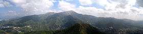 Tai Mo Shan, viewed from Tai To Yan | |
| Highest point | |
| Elevation | 957 m (3,140 ft) |
| Coordinates | 22°24′42.52″N 114°7′23.32″E / 22.4118111°N 114.1231444°ECoordinates: 22°24′42.52″N 114°7′23.32″E / 22.4118111°N 114.1231444°E |
| Geography | |
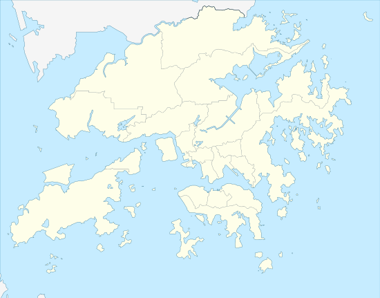 Tai Mo Shan Location of Tai Mo Shan in Hong Kong | |
| Location | Centre of the New Territories, Hong Kong |
| Tai Mo Shan | |||||||||||||||
| Traditional Chinese | 大帽山 | ||||||||||||||
|---|---|---|---|---|---|---|---|---|---|---|---|---|---|---|---|
| Literal meaning | Big Hat Mountain | ||||||||||||||
| |||||||||||||||
%2C_and_Tai_Mo_Shan_peak_in_distance.JPG)

Tai Mo Shan (Chinese: 大帽山) is the highest peak in Hong Kong, with an elevation of 957 m.[1] It is also the tallest coastal peak in Southern China and second tallest coastal peak in China after Mount Lao, and located at approximately the geographical centre of the New Territories.
The Tai Mo Shan Country Park covers an area of 14.40 km² around Tai Mo Shan.[1] It is located to the north of Tai Lam Country Park. It is noted to have the 35-metre high Long Falls, the highest waterfall in Hong Kong.[2]
Geography
The whole Tai Mo Shan mountain range, known as Guang Fu Mountain (官富山, named after the salt field Kwun Fu Cheung (官富場) in present-day Kowloon Bay) in Ming and Qing dynasties, covers over 350 square km, and stretches from Tai Lam Chung Reservoir in the West near Tuen Mun and Ma On Shan in the east and the mountains of Kowloon and Clear Water Bay in the south. Two other significant coastal peaks, the Lantau Peak (934m) on Lantau Island and Mount Wutong in Shenzhen (943.7m) are approximately 27 km to the southwest and 21.5 km to the northeast respectively.
Geology
As a former volcano, that has long been extinct, Tai Mo Shan is composed of volcanic rocks from the Jurassic age. Today a small hill that is part of Tai Mo Shan, known as "Kwun Yum Shan", still vents warm air though cracks in the rocks that lead all the way to the mantle. The holes that exhale warm air are known as "hot pots". When the surface temperature is cold, and the warmth of the expelled air is clearly discernible, this phenomenon is referred to by locals as "dragon's breath". If the air temperature at the summit is 6 degrees Celsius, then the air emerging from the interior of Kwun Yum Shan is somewhere between 13 and 21 degrees Celsius. These "hot pots" are now just mild remnants of the intense superheated steam vents of the volcanic past.[3] The volcanic rocks are mainly coarse ash crystal tuff.[4]
Weather
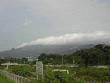
Under the Köppen climate classification, Tai Mo Shan features a humid subtropical climate (Cwa), bordering a subtropical highland climate (Cwb). Due to the height of the mountain, Tai Mo Shan is claimed to be Hong Kong's most misty area, as it is often covered in clouds. In summer it is frequently covered with cumulus clouds, especially on rainy days, and in winter stratus clouds and fog often cover the peak.
| Climate data for Tai Mo Shan (1997–2015) | |||||||||||||
|---|---|---|---|---|---|---|---|---|---|---|---|---|---|
| Month | Jan | Feb | Mar | Apr | May | Jun | Jul | Aug | Sep | Oct | Nov | Dec | Year |
| Record high °C (°F) | 21.5 (70.7) |
23.2 (73.8) |
24.2 (75.6) |
27.4 (81.3) |
27.1 (80.8) |
28.9 (84) |
28.8 (83.8) |
29.4 (84.9) |
28.0 (82.4) |
26.6 (79.9) |
25.2 (77.4) |
23.7 (74.7) |
29.4 (84.9) |
| Average high °C (°F) | 13.8 (56.8) |
15.1 (59.2) |
17.0 (62.6) |
19.7 (67.5) |
22.0 (71.6) |
23.4 (74.1) |
24.2 (75.6) |
24.6 (76.3) |
23.6 (74.5) |
21.3 (70.3) |
18.2 (64.8) |
14.6 (58.3) |
19.8 (67.6) |
| Daily mean °C (°F) | 10.4 (50.7) |
11.9 (53.4) |
14.1 (57.4) |
17.3 (63.1) |
20.0 (68) |
21.6 (70.9) |
22.1 (71.8) |
22.2 (72) |
21.0 (69.8) |
18.4 (65.1) |
15.3 (59.5) |
11.3 (52.3) |
17.1 (62.8) |
| Average low °C (°F) | 7.7 (45.9) |
9.3 (48.7) |
11.8 (53.2) |
15.3 (59.5) |
18.2 (64.8) |
20.0 (68) |
20.4 (68.7) |
20.4 (68.7) |
19.2 (66.6) |
16.4 (61.5) |
13.0 (55.4) |
8.8 (47.8) |
15.0 (59) |
| Record low °C (°F) | −6.0 (21.2) |
−1.8 (28.8) |
−2.0 (28.4) |
5.6 (42.1) |
9.3 (48.7) |
14.0 (57.2) |
16.8 (62.2) |
18.1 (64.6) |
13.3 (55.9) |
5.7 (42.3) |
−0.3 (31.5) |
−3.3 (26.1) |
−6.0 (21.2) |
| Average precipitation mm (inches) | 30.7 (1.209) |
42.2 (1.661) |
82.6 (3.252) |
164.0 (6.457) |
349.8 (13.772) |
522.3 (20.563) |
418.6 (16.48) |
357.0 (14.055) |
293.4 (11.551) |
76.2 (3) |
36.2 (1.425) |
28.7 (1.13) |
2,401.7 (94.555) |
| Average rainy days (≥ 0.5 mm) | 11.3 | 14.6 | 18.4 | 20.8 | 22.6 | 23.4 | 22.9 | 18.8 | 16.9 | 11.9 | 10.3 | 8.6 | 200.5 |
| Average relative humidity (%) | 82 | 89 | 91 | 92 | 94 | 96 | 95 | 93 | 91 | 87 | 84 | 78 | 89 |
| Source: Hong Kong Observatory[5][6][7][8] | |||||||||||||
Vegetation
In the past, Tai Mo Shan was famous for a type of green tea, called mist or cloud tea, which grew wild on the mountain side. Occasionally, local people can still be seen picking the tea shoots for brewing green tea.
More than 1,500 species of plants have been recorded in Tai Mo Shan including 27 species of native wild orchids, the protected Chinese Lily (Lilium brownii) which mostly grows on the east side of the Mountain, 24 species of native ferns, including tree ferns, of which a total of only 4 tree ferns species have been recorded around the entire mountain, 19 species of native grasses, and 7 species of native bamboos. Camellia sinensis var. waldenae (formerly Camellia waldenae) are also found on the mountain.
A few types of wild orchids also grow in the streams of Tai Mo Shan including the Chinese pholidota orchid, Hong Kong's most common orchid, and the bamboo orchid, so called because of a distinct stem that looks like bamboo, which also grows in the streams of Tai Mo Shan.
During the Japanese occupation of Hong Kong in World War II, most of the trees in the park were cut down and extensive reafforestation was carried out after the war. Trees that were planted are mostly non-native such as Pinus massoniana, Acacia confusa, Lophostemon confertus, and paper bark tree. The area has now become one of the major forest plantations in Hong Kong.
Wildlife
Local wildlife comprises birds, snakes and butterflies.[1] There are also freshwater crabs, feral dogs, feral cats, oxen and wild boar.
History
In 1986, a 34-hour blaze destroyed 282,500 trees at Shing Mun and Tai Mo Shan and ravaged 7.40 km² of countryside.
Access
It is rather easy to hike to the peak as there is a road all the way at a comfortable gradient. Visitors cannot access the highest point on Tai Mo Shan, as it is occupied by a Hong Kong Observatory (ex-RAF) weather radar station. It was reported in July 2014 that the station additionally houses facilities of the People's Liberation Army.[9]
See also
- List of mountains, peaks and hills in Hong Kong
- Country parks and conservation in Hong Kong
- Kadoorie Farm and Botanic Garden
References
- 1 2 3 "Tai Mo Shan Country Park". Agriculture, Fisheries and Conservation Department. Retrieved 8 February 2015.
- ↑ Kabange, Sanday Chongo (24 July 2012). "The better side of Hong Kong: Top 10 nature reserves". CNN Travel. Retrieved 20 November 2012.
- ↑ "8 Mesozoic Post-Volcanic and Tertiary Sedimentary Rocks". CEDD. Retrieved 20 December 2008.
- ↑ R.J. Sewell, S.D.G. Campbell, C.J.N. Fletcher, K.W. Lai & P.A. Kirk (2000). The Pre-Quaternary Geology of Hong Kong. Government of Hong Kong SAR. ISBN 962-02-0299-6.
- ↑ "Monthly Means of Meteorological Elements for Tai Mo Shan, 1997-2015". Hong Kong Observatory. Retrieved April 5, 2016.
- ↑ "Monthly Means of Meteorological Elements for Tai Mo Shan, 1997-2015: Cold/Hot Weather and Rainfall statistics". Hong Kong Observatory. Retrieved April 5, 2016.
- ↑ "Monthly Maximum Temperature (°C) at Tai Mo Shan, 1997-2015". Hong Kong Observatory. Retrieved July 4, 2016.
- ↑ "Monthly Minimum Temperature (°C) at Tai Mo Shan, 1997-2015". Hong Kong Observatory. Retrieved July 4, 2016.
- ↑ Cheung, Chi-fai; Wong, Olga (July 23, 2014). "Hong Kong 'hands PLA radar station on territory's highest mountain in secret deal'". South China Morning Post. Hong Kong.
External links
| Wikimedia Commons has media related to Tai Mo Shan. |