Talakivka
| Talakivka Талаківка | |||
|---|---|---|---|
| Urban-type settlement | |||
|
| |||
| |||
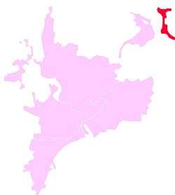
 Talakovka is marked with dark red | |||
 Talakivka Location of Talakivka within Ukraine | |||
| Coordinates: UA 47°11′7″N 37°43′19″E / 47.18528°N 37.72194°ECoordinates: UA 47°11′7″N 37°43′19″E / 47.18528°N 37.72194°E | |||
| Country | Ukraine | ||
| Province | Donetsk Oblast | ||
| Founded | 1889 | ||
| Area | |||
| • Total | 2.39 km2 (0.92 sq mi) | ||
| Elevation | 6 m (20 ft) | ||
| Population (Est. 2016) | |||
| • Total | 4,081 | ||
| • Density | 1,700/km2 (4,400/sq mi) | ||
| Time zone | EET (UTC+2) | ||
| • Summer (DST) | EEST (UTC+3) | ||
| Postal code | 87594-87595 | ||
| Area code | +380 629 | ||
Talakivka (Ukrainian: Талаківка; Russian: Талаковка) is an urban-type settlement in Kalmius Raion of Mariupol city in Donetsk Oblast of eastern Ukraine, at 89.4 km SSW from the centre of Donetsk city, at a distance of 19 km north from the centre of Mariupol, on the right bank of the Kalmius river. Population: 4,081 (2016 est.)[1].
Demographics
In 2001 the settlement had a population of 4160. Native language as of the Ukrainian Census of 2001:[2]
- Ukrainian 10.31%
- Russian 89.47%
- Greek 0.10%
- Belorussian 0.07%
Dynamics of population has been as follows:[3]
| Year | Population |
|---|---|
| 1897 | 652 |
| 1959 | 2886 |
| 1970 | 3574 |
| 1979 | 4502 |
| 1987 | 4600 |
| 1988 | 4600 |
| 1989 | 3848 |
| 1992 | 3900 |
| 1998 | 3800 |
| 2001 | 4160 |
| 2004 | 4100 |
| 2009 | 4160 |
| 2010 | 4155 |
| 2011 | 4129 |
| 2012 | 4137 |
| 2013 | 4130 |
| 2014 | 4133 |
| 2015 | 4113 |
References
- ↑ "Чисельність наявного населення України (Actual population of Ukraine)" (PDF) (in Ukrainian). State Statistics Service of Ukraine. Retrieved 19 July 2016.
- ↑ Розподіл населення за рідною мовою на ukrcensus.gov.ua
- ↑ Населення міст та смт України
This article is issued from Wikipedia - version of the 10/13/2016. The text is available under the Creative Commons Attribution/Share Alike but additional terms may apply for the media files.

