Talim Island
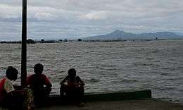 Talim Island with Mount Tagapo as seen from Los Baños pier at dusk | |
.svg.png) Talim Island Location within the Philippines | |
| Geography | |
|---|---|
| Location | Laguna de Bay |
| Coordinates | 14°21′7″N 121°13′54″E / 14.35194°N 121.23167°ECoordinates: 14°21′7″N 121°13′54″E / 14.35194°N 121.23167°E |
| Administration | |
| Region | CALABARZON |
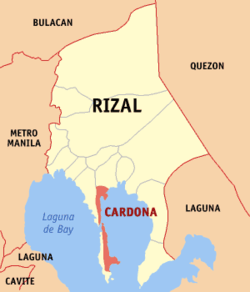
| Province | Rizal |
| Municipalities | |
Talim Island is the largest lake island in Laguna de Bay, the largest lake in the Philippines. The hilly island is within the boundaries of the Province of Rizal, under the jurisdiction of two municipalities. The western side is part of the municipality of Binangonan, while the eastern section is part of Cardona.
The island is volcanic in origin and forms the southwest rim of the Laguna Caldera. Volcanism after the formation of the caldera created the maars and volcanic craters at the southern end of Talim Island,[1] the largest of which is a 3-kilometre (1.9 mi) crater surrounding Brgys. Balibago and Tuna.[2]
Political subdivision
The island consists of 24 barangays that lie along its shores, 17 belongs to the town of Binangonan and 7 to Cardona.
|
|

Geography
Talim Island is located almost at the center of Laguna de Bay, a three-lobed lake the center of which is the Laguna Caldera. The northernmost tip of the island is separated from the mainland by Diablo Pass, which is only about 240 meters (790 ft) at the narrowest. The southernmost tip of the island is called Talim Point.
The highest point of the island is Mount Tagapo, known locally as "Bundok ng Susong Dalaga" (Maiden's breast mountains) for the conical hill at its peak resembling the female breast. The hill is among the several in the Tagalog region that are called as such because of its shape. This feature is best observed from neighboring Mount Sembrano in the Jalajala peninsula across the lake.[3]
Economy
The island is rich in bamboo grass, which the islanders make into different types of furniture such as bamboo sofas, cabinets, tables, chairs and a lot more. It is their main source of living, while lake fishing is only secondary.
Religion
Two Roman Catholic parish churches are located on the island. [4] The Santo Domingo Parish Church is in Janosa, Binangonan, and Our Lady of Lourdes Parish Church, in Navotas, Cardona. Also, few of Jehovah's Witnesses [5][6] lives on the island, and they have 3 meeting places called Kingdom Hall. [7][8] The Iglesia ni Cristo [9] has a place of worship [10] in Barangay Subay, Cardona.
See also
References
- ↑ "Laguna Caldera". Global Volcanism Program. Smithsonian Institution. Retrieved 2013-09-18.
- ↑ "Port of Balibago". Google Maps. Retrieved on 2013-09-18.
- ↑ "Destination Mt. Sembrano".
- ↑ "Our Lady of Lourdes Parish"
- ↑ "Jehovah's Witnesses Official Website"
- ↑ "Opisyal na Website ng mga Saksi ni Jehova"
- ↑ "meaning of Kingdom Hall"
- ↑ "Kahulugan ng Kingdom Hall"
- ↑
- ↑
External links
 Media related to Talim Island at Wikimedia Commons
- Talim Island at OpenStreetMap
- Philippine Standard Geographic Code
- 2000 Philippine Census Information
"The Largest Lake in the Philippines" | |||||||||||
| Location |  | ||||||||||
| Basin country | |||||||||||
| Islands | |||||||||||
| Primary outflow | |||||||||||
| Primary inflows |
| ||||||||||
| Settlements | |||||||||||