San Pedro, Laguna
| San Pedro | ||
|---|---|---|
| Component City | ||
| City of San Pedro | ||
|
San Pedro and Muntinlupa boundary marker on 2013 | ||
| ||
|
Nickname(s): The Sampaguita Capital of the Philippines; Rooster City of the Phlippines; Laguna's Gateway to Metro Manila[1] | ||
|
Motto: Sipag at Pananampalataya sa Diyos tungo sa Kaunlaran ng San Pedro (Hardwork and Faith in God towards San Pedro's progress); Magandang San Pedro Po | ||
 Map of Laguna showing the location of San Pedro | ||
.svg.png) San Pedro Location within the Philippines | ||
| Coordinates: 14°21′30″N 121°03′30″E / 14.3583°N 121.0583°ECoordinates: 14°21′30″N 121°03′30″E / 14.3583°N 121.0583°E | ||
| Country | Philippines | |
| Region | Calabarzon (Region IV-A) | |
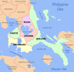
| Province | Laguna | |
| District | 1st district of Laguna | |
| Founded | January 18, 1725 | |
| Cityhood | December 28, 2013[2][3] | |
| Barangays | 27 | |
| Government[4] | ||
| • City Mayor | Lourdes Catáquiz (Liberal) | |
| • City Vice Mayor | Iryne Vierneza (PDP-Laban) | |
| • City Council | ||
| Area[5] | ||
| • Total | 24.05 km2 (9.29 sq mi) | |
| Highest elevation | 117.348 m (385.000 ft) | |
| Population (2015 census)[6] | ||
| • Total | 325,809 | |
| • Density | 14,000/km2 (35,000/sq mi) | |
| Demonym(s) |
San Pedronian (en.); San Pedrense (tl.) | |
| Time zone | PST (UTC+8) | |
| ZIP code | 4023 | |
| Dialing code | +63 (0)02 | |
| Income class | 1st class | |
| Website |
cityofsanpedrolaguna | |

San Pedro is a first class city in the province of Laguna, Philippines, officially City of San Pedro (Filipino: Lungsod ng San Pedro) and often referred to as San Pedro City is named after its patron saint, Peter the Apostle.[7] According to the 2015 census, it has a population of 325,809 inhabitants.[6] Despite being the third smallest in the entire province, with a total land surface area of only 24.05 km2, San Pedro is the fourth largest city in terms of population after the cities of Calamba, Biñan, and Santa Rosa. The city also has the highest population density in the province of Laguna and in the whole CALABARZON Region having 14,000 people/km2.[7]
History
San Pedro de Tunasán became a town on January 18, 1725, when King Charles II of Spain decreed that the town formerly known as "Tabuko" be a separate town from "Kabullaw" (now known as the city of Cabuyao).[7]
By virtue of the last will of Philip V of Spain, Rodriguez de Figueroa or "Don Esteban", a group of Augustinian Fathers gained the ownership of the Tunasán Estate. Later on, San Pedro became an hacienda of Colegio de San José, a group of Jesuits friars who took over the property which now is known as "San Pedro Tunasán". "Tunasán" literally means "a place where there is Tunás" (Nymphaea nouchali), a medicinal plant abundant on shoreline area.[7]
During that period, agriculture, fishing, duck raising, fruit trees, sampaguita were the main source of income of its residents. This period was highlighted by the growing tenant/landlord dispute. The tenants of Hacienda San Pedro Tunasán fought for their birthrights over their ancestral lands. This struggle took almost 423 years of unsuccessful resistance to Colegio de San José, and in 1938, the government bought the homesites of the San Pedro Tunasán Hacienda from the Colegio for re-sale to its tenants. This event laid to rest the tenants/landlord problem in the town.
In the year 1902, the name San Pedro de Tunasán was simplified to San Pedro.
From the Spanish time until after the Japanese occupation of the Philippines, the scenario did change a bit, when on August 30, 1954, beginning to the Philippine Commonwealth forces against the Japanese, President Ramón Magsaysay signed at the historic town plaza the Land Tenancy Act. By virtue of this law, farm lots of the hacienda were bought by the Philippine Government to be sold at cost to the tenants or occupants of the farm lots in Bayan-Bayanan under the Narra Settlement Project of the Magsaysay Administration.
Cityhood

On March 27, 2013, President Benigno Aquino signed the 64-page Republic Act No. 10420[8] converting the municipality into a new component city of the province of Laguna. The cityhood of San Pedro was ratified through a plebiscite scheduled by the Commission on Elections (COMELEC). The date for the ratification is December 28, 2013 after the National Barangay Elections. It became the sixth city of Laguna after the cities of Biñan, Cabuyao, Calamba, San Pablo and Santa Rosa, and also the third to be a city in the 1st congressional district of Laguna - making it the first city district in the province.
COMELEC officially proclaimed the first-class municipality of San Pedro as a component city of Laguna on December 29, 2013. Juanito Icarro, regional director of CALABARZON and MIMAROPA, and Marianne Marfori, provincial election supervisor, made the proclamation at the municipal hall after San Pedro residents voted for the cityhood in a plebiscite held on December 28, 2013. "Yes" votes for cityhood totaled 16,996 (which is additional 50 votes added in some precincts mostly in San Vicente area to win the "Yes" vote), and "No" votes, only 869, in 501 clustered precincts in San Pedro. Only 11% of 165,777 registered voters in San Pedro's 20 barangays took part in the plebiscite.

Geography
San Pedro is located in Region 4A or CALABARZON. San Pedro is the boundary between Laguna and Metro Manila, so San Pedro is known as "Laguna's Gateway to Metro Manila". San Pedro shares boundaries with Metro Manila's southernmost city, Muntinlupa (North), Biñan (South), Dasmariñas (West), Carmona and Gen. Mariano Alvarez (SouthWest). Its position makes San Pedro a popular suburban residential community, where many residents commute daily for work to Metro Manila.[7]
Barangays
San Pedro is politically subdivided into 27 barangays. Brgy. San Antonio is the largest barangay, which has a total of 780 hectares. While Brgy. San Vicente is the most populous with a total population of 92,092.[9]
- Bagong Silang
- Calendola
- Chrysanthemum1
- Cuyab
- Estrella
- Fatima2
- G.S.I.S.
- Landayan
- Langgam
- Laram
- Maharlika3
- Magsaysay
- Narra
- Nueva
- Pacita 14
- Pacita 25
- Poblacion
- Riverside
- Rosario6
- Sampaguita Village
- San Antonio
- San Roque
- San Vicente
- San Lorenzo Ruiz7
- Sto. Niño
- United Bayanihan
- United Better Living
1 2 3 4 5 6 7^Seven (7) new barangays created as separate and distinct from its mother Brgy. San Vicente after it were
ratified and approved through a plebiscite held on July 11, 2015 under COMELEC Resolution No. 9969.[10]
Climate
| Climate data for San Pedro City, Philippines | |||||||||||||
|---|---|---|---|---|---|---|---|---|---|---|---|---|---|
| Month | Jan | Feb | Mar | Apr | May | Jun | Jul | Aug | Sep | Oct | Nov | Dec | Year |
| Average high °C (°F) | 30 (86) |
31 (88) |
32 (90) |
34 (93) |
34 (93) |
33 (91) |
32 (90) |
31 (88) |
32 (90) |
32 (90) |
31 (88) |
30 (86) |
31.8 (89.4) |
| Average low °C (°F) | 24 (75) |
24 (75) |
25 (77) |
27 (81) |
27 (81) |
26 (79) |
26 (79) |
25 (77) |
26 (79) |
26 (79) |
26 (79) |
25 (77) |
25.6 (78.2) |
| Average precipitation mm (inches) | 32.9 (1.295) |
31.7 (1.248) |
28.2 (1.11) |
26.9 (1.059) |
188.9 (7.437) |
225.7 (8.886) |
420.0 (16.535) |
377.9 (14.878) |
332.4 (13.087) |
145.1 (5.713) |
128.8 (5.071) |
76.3 (3.004) |
2,014.8 (79.323) |
| Average rainy days | 6 | 6 | 4 | 4 | 12 | 18 | 21 | 23 | 21 | 17 | 14 | 10 | 156 |
| Source: World Weather Online[11] | |||||||||||||
Demographics
| Population census of San Pedro | ||
|---|---|---|
| Year | Pop. | ±% p.a. |
| 1990 | 156,486 | — |
| 1995 | 189,333 | +3.63% |
| 2000 | 231,403 | +4.40% |
| 2007 | 281,808 | +2.76% |
| 2010 | 294,310 | +1.59% |
| 2015 | 325,809 | +1.95% |
| Source: National Statistics Office; LWUA; Philippine Statistics Authority[6][12][13] | ||
The City of San Pedro is the 37th most populous city and youngest city in the Philippines. As of 2015, the population is 325,809, up from 294,310 in 2010, or an increase of almost 11%. Its area is 24.05 square kilometres (9.29 sq mi) with a density of 13,547/km2 (35,087/sq mi).
Religion
San Pedro is home for the Famous Krus ng San Pedro Tunasán. Majority of the people are Roman Catholics. Other religious groups include are the Members Church of God International (MCGI), Jesus Miracle Crusade International Ministry (JMCIM), United Church of Christ in the Philippines (UCCP), Jesus Is Lord Church (JIL), Jesus Christ the Lifegiver Ministries (JCLM), Iglesia Ni Cristo (INC), The United Methodist Church, Presbyterian Churches, Christian Bible Baptist Church, other Baptist and Bible Fundamental churches. Islam is also practiced within the community. There are 15 Catholic parishes in the city, and one mosque.
Economy
The largest barangay with industry, manufacturing, supermarkets, and stores in San Pedro are San Antonio, these barangay have the largest areas in San Pedro. The city center and city proper or poblacion (San Pedro) is where most of the San Pedronians go to buy their goods. San Pedro also has a large number of factories surrounding it. Most of the factories are located at Magsaysay Rd. in San Antonio.
Agriculture
Agriculture lands now account for only thirteen hectares of the total land area due to residential, commercial and industrial conversions. There are lands with slope ranging from 8% - 15% of the total land area located in parts of Barangay San Antonio and San Vicente planted with mangoes and siniguelas trees. Livestock and poultry businesses operate in the area.
Commerce and industry
There are 4,705 total business establishments, 40 commercial, savings and rural banks, 117 restaurant, cafeteria, and other refreshment parlor, and two public and five private markets and supermarkets. There are 40 banks, 62 pawnshops, 36 lending institutions and 11 insurance companies operating in the city. A large percentage of industrial and manufacturing establishments of San Pedro is located on the adjacent barangays of San Vicente and San Antonio.
Tourism
City of San Pedro has a 20 km tourism belt to promote the hidden beauty of the city and to attract more tourist to visit the city.
Sampaguita Festival
The annual City Festival is celebrated on the 2nd week of February. A week-long festival which includes various activities ranging from cultural to sports, trade fairs, amateur singing contests, parades, historical exhibits, social & religious gatherings, tribal dances, street dances, cheering & sport exhibitions. The highlight of the festival is the coronation night of the "Hiyas ng San Pedro". The festival aims to promote tourism in San Pedro and to revitalize Sampaguita industry in the community.
San Pedro City holds the record of laying the longest sampaguita (flower lei) line spanning 3.6 km (2 mi), from Biñan City-San Pedro City boundary to San Pedro City-Muntinlupa City boundary on the National Highway, making them listed in the Guinness World Records in 2009.
Christmas Festival
"Paskuhan Sa San Pedro" is an annually celebrated festival in San Pedro City. It starts at the beginning of December up to the end of the month. The opening is a grand parade which is participated by public and private schools in the city, local government and other socio-civic organizations. The main event of the opening is the lighting of the whole plaza, fireworks display, and various performance of some school. Every night a variety of shows were performed by the participants which last up to midnight. During the 29 December of every year the Cityhood Anniversary of San Pedro is celebrated.
Landmarks
The most popular landmarks in San Pedro include:
- KC Filipinas Golf Club in Brgy. San Antonio
- Philippine Amusement and Gaming Corporation (PAGCOR) VIP Casino Filipino in San Pedro Town Center, Brgy. San Antonio
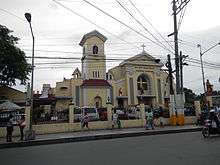
- San Pedro Apostol Parish in Brgy. Poblacion
- Pacita Complex
- Pacita Astrodome
- Shrine of Sto. Sepulcro in Brgy. Landayan
- Balon ni Lolo Uweng in Brgy. Landayan
- Mary Mother of Mercy
- Salvador Laurel Museum (Laurel Hills)
- Dambana Island Park (along A. Mabini corner National Highway)
- Roosters or Manok ni San Pedro (Muntinlupa-San Pedro Boundary)
- San Pedro Gateway Park (gateway of Laguna from Metro Manila)
- Historic City Plaza
- San Pedro Town Center (where many commercial establishments are located) sits on the former location of the public cemetery.

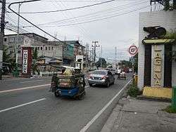
Transportation
In the city there are jeepneys, tricycles, vans, and bus terminals that provide transportation to every part of the city or outside city.
Public transport
Buses with lines from Metro Manila serve the city. Jeepneys provides service between the city and nearby areas and the city's barangays. Tricycles and pedicabs serves the barangays and subdivisions (gated communities).
Roads
The city is served by one expressway, one national highway, and a network of arterial roads serving the surrounding barangays.
Expressways and national highways

South Luzon Expressway serves the city, with one exit, San Pedro Exit (Exit 27). Laguna Lakeshore Expressway Dike, a proposed expressway, will serve the city's eastern part.
The "National Highway" (Daang Maharlika/Maharlika Highway or formerly Manila South Road), passes through San Antonio, Nueva, Poblacion, and Landayan. This highway is mainly plied by jeepneys, serving routes between Alabang and Calamba, Laguna.
Railway
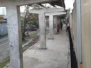
Philippine National Railway Metro Commuter Line serves the city with 2 railroad stations:
Healthcare
Throughout the city, healthcare is primarily provided at the Barangay Health Centers in every barangay. Also, several medical missions are operated and provided by local and international organizations. The major hospitals in the city are:
- Jose L. Amante Emergency Hospital (Brgy. Sto.Nino)
- Gavino Alvarez Lying-In Center (Brgy. Narra)
- San Pedro Doctors Hospital (Manila South Road-Landayan)
- Divine Mercy Hospital (Guevarra Subd.)
- Westlake Medical Center (Manila South Road-Pacita Complex)
- Evangelista Medical Specialty Hospital (Macaria Ave.-Pacita Complex)
- Family Care Hospital (Macaria Ave.-Pacita Complex)
Subdivisions and villages
San Pedro City is home for a large number of subdivisions and villages such as:
- Adelle
- Adelina Subdivision
- AlconVille Village
- Calendola Homes
- Camella Homes - Colina
- Camella Homes Milan
- Camella Homes South 1
- Camella Homes Woodhills
- Carmen Homes
- Chrysanthemum Village
- Crismor Subdivision
- Cristina Homes Subdivision
- Dreamland Heights
- Elnor Homes Subdivision
- Elvinda Homes
- Fiesta Homes
- Futura Homes
- GSIS Village
- Greatland Subdivision
- Guevara Subdivision
- La Marea
- LakeVille Subdivision
- Harmony Homes
- Holiday Homes
- Holiday Hills
- Holiday Park Subdivision
- Ma. Aurora Heights Subdivision
- Pacita Complex I & II
- Park Spring
- Reaville
- Rosa I and II
- Pitimini Village
- Rosario Complex
- Sampaguita Village
- San Isidro Village
- Santo Niño Subdivision
- SouthHills Subdivision
- South Peak
- Southern Heights
- Southville 3A
- South Fairway Village
- St. Joseph Village 9
- St. Joseph Village 10
- St. Francis
- Saint Raymond Village
- Southview Homes
- Southern Heights I & II
- Stonecrest Village
- The Glens At Park Spring
- The Pines At South Peak
- Villa Ricardo Subdivision
- Villa Olympia
- Villa Paz Village
- Villa Castillo Subdivision
- Villa Celestina
- Villa Consolation
- Villa San Pedro
- Villa Rosa Homes
- United San Pedro Subdivision
Education
San Pedro hosts a number of institutions of education such as:
- Academia Institucion De San Pedro
- Agnus Dei School Systems, Inc.
- Angelicum Academy
- AMA Computer Learning Center - San Pedro
- Asian Institute Of Computer Studies - San Pedro
- Amazing Grace School
- Casa Del Niño Schools System, Inc.
- Caterina and Giuditta Cittadini School
- Colegio de San Pedro
- Computer Site Institute, Inc. (COMSITE)
- Creative School of San Pedro (CSSP)
- Golden Lampstand Grade School
- IETI College Of Science and Technology - San Pedro
- Excellent Wisdom Christian Academy
- Immaculate Heart of Mary School
- Infant Jesus Montessori Center - San Pedro
- Jesus The Faithful Savior Christian School
- Jesus The Risen Savior School - De La Salle Supervised
- Joseph and Mary Academy
- Laguna Northwestern College (San Pedro & Pacita Complex)
- Laguna Science and Technology College
- Liceo de San Pedro
- Lord's Shepherd School of Laguna
- Malasaga Institute of Technology
- Mater Ecclesiae School
- Our Lady of Assumption College
- Our Lady of Miraculous Medal Science High School
- Pacita Complex National High School
- Polytechnic University of the Philippines - San Pedro
- San Lorenzo School
- St. Louis Anne Colleges (Pacita Complex & San Vicente Annex)
- St. Peter Academy
- Sampaguita Village National High School (Calendola & Adelina)
- Salt & Light Community Christian School
- San Francisco De Sales School
- Saint Francis Institute Of Computer Studies
- San Pedro College of Business Administration
- San Pedro Relocation Center National High School (Langgam, Cuyab & Landayan)
- San Pedro Technological Institute (Formerly San Pedro Manpower Development Institute)
- Sisters of Mary Immaculate School
- St. Paul Montessori School
- St. Therese of the Child Jesus School
- STI College San Pedro
- Christian Bible Baptist Academy
- Christian Bible Baptist Church School for The Deaf
- Baptist Heritage Bible College
- Tiwalan Christian Academy
- Wellspring Of Grace School
- Upper Villages Christian Academy
- Sto. Nino Montessori of Academic Excellence
Notable people
- Cacai Bautista, comedian
- Charice Pempengco, singer
- Christopher Roxas, actor
- Desiree Verdadero, Miss Universe 1984 3rd runner-up
- Gladys Reyes, actress
- Jamilla Obispo, actress
- Jan Manual, actor
- John Lloyd Cruz, actor, model
- Julia Clarete, TV host, actress
- Kristine Hermosa, actress
- Nikki Valdez, actress
- Ogie Diaz, comedian, columnist and TV host
- Paw Diaz, actress
- Princess Snell, actress
- Rico Blanco, singer, former vocalist of Rivermaya
- Rocco Nacino, actor
- Salvador Laurel, 5th Prime Minister of the Philippines
- Stephanie Retuya, contestant and runner-up in Asia's Next Top Model (cycle 1)
So, these are the notable people from San Pedro. Like, what is wrong with our produce?
Twin towns – Sister cities
San Pedro's sister city is Makati City. San Pedro is also twinned with Dupax del Norte, Nueva Vizcaya and Unisan, Quezon.
| Local |
|---|
References
- ↑ San Pedro City, Laguna, Philippines - Welcome Message
- ↑ San Pedro now a component city of Laguna - Philstar.com
- ↑ http://www.comelec.gov.ph/?r=Archives/Plebiscites/PlebiscitesSanPedroLaguna
- ↑ "Official City/Municipal 2013 Election Results". Intramuros, Manila, Philippines: Commission on Elections (COMELEC). 11 September 2013. Retrieved 18 November 2013.
- ↑ "Province: LAGUNA". PSGC Interactive. Makati City, Philippines: National Statistical Coordination Board. Retrieved 18 November 2013.
- 1 2 3 "Region IV-A (CALABARZON)". Census of Population (2015): Total Population by Province, City, Municipality and Barangay (Report). PSA. Retrieved 20 June 2016.
- 1 2 3 4 5 San Pedro, Laguna Official Website - History
- ↑ http://www.gov.ph/2013/03/27/republic-act-no-10420/
- ↑ "MUNICIPALITY/CITY:City of San Pedro". Philippine Statistics Authority (National Statistical Coordination Board).
- ↑ "PLEBISCITE TO RATIFY THE CREATION OF SEVEN (7) NEW BARANGAYS SEPARATE AND DISTINCT FROM ITS MOTHER BARANGAY OF SAN VICENTE, SAN PEDRO CITY, LAGUNA". Philippines: Commission of Elections. June 11, 2015. Archived from the original on July 20, 2015.
- ↑ "San Pedro Average Temperatures and Rainfall". World Weather Online. Retrieved July 27, 2015.
- ↑ "Total Population by Province, City, Municipality and Barangay: as of May 1, 2010" (PDF). 2010 Census of Population and Housing. National Statistics Office. Retrieved 18 November 2013.
- ↑ "Province of Laguna". Municipality Population Data. LWUA Research Division. Retrieved 19 November 2013.
External links
| Wikimedia Commons has media related to San Pedro, Laguna. |
- Philippine Standard Geographic Code
- Philippine Census Information
- Local Governance Performance Management System
 |
Muntinlupa | | ||
| Dasmariñas, Cavite | |
Laguna de Bay | ||
| ||||
| | ||||
| Gen. Mariano Alvarez, Cavite / Biñan |