Tannersville Cranberry Bog
| Tannersville Cranberry Bog | |
|---|---|
|
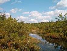
Black spruce and tamarack near the bog's center | |
 Map of Pennsylvania | |
| Location | Tannersville, Pennsylvania |
| Coordinates | 41°02′32″N 75°15′32″W / 41.04222°N 75.25889°WCoordinates: 41°02′32″N 75°15′32″W / 41.04222°N 75.25889°W |
| Area | 1,000 acres (400 ha) |
| Established | 1956 |
| Governing body | The Nature Conservancy |
| Website | |
| Designated | 1974 |

The Tannersville Cranberry Bog or Cranberry Swamp, is a sphagnum bog on the Cranberry Creek in Tannersville, Pennsylvania. It is the southernmost boreal bog east of the Mississippi River, containing many black spruce and tamarack trees at the southern limit of their ranges. Technically, it can be classed as an acid fen, as it receives some groundwater flow. The site was designated a National Natural Landmark in December 1974.[1] It was purchased by The Nature Conservancy and the Conservation and Research Foundation[2] in 1957. Like many bogs, its terrain presents an image of solidity, but a liquid mass of decaying peat lies beneath a six-inch (152 mm) layer of sphagnum and a network of supporting tree roots. However, this bog may be viewed from a floating walkway.
History
The bog began as a "kettle lake" formed approximately 10,000 years ago by a portion of the retreating Wisconsin Glacier (named according to geologic epoch, not location), which initially covered a depth up to the top of the current forest canopy. With restricted air and nutrient flow, sphagnum moss grew out into the lake, eventually forming a layer of peat over 40 feet (12 m) thick. While young bogs may contain an "eye" of open water where sphagnum has not yet reached, no such feature remains in the Tannersville Cranberry Bog. However, a narrow strip of open water marks the course of the Cranberry Creek, where the water is less acidic.
Flora

- Sphagnum moss
- Conifers
- black spruce
- tamarack ("American larch", a deciduous conifer that lends a brilliant yellow hue in autumn)
- Heath plants
- Parasitic plants
- Grasses
- sedges (in more nutrient-rich areas)
- cotton grass
- yellow-eyed grass
- Insectivorous plants
- Sun-loving plants (these are giving way to natural succession as heath plants predominate)
- Labrador tea
- golden-club (Orontium aquaticum)
- hartford fern (Lygodium palmatum)
- Orchids
- grass pink
- white-fringed orchid
- rose pogonia
- yellow lady's slipper
- heart-leaf twayblade (not seen in recent years)
- wild calla
- gold thread[3]
- winterberry[3]
- sumac
Fauna
- Carnivora
- black bear
- bobcat
- coyote
- gray fox
- mink
- river otter (Cranberry Creek)
- Rodents
- Breeding birds
- Others
- bog turtle
- pickerel (Cranberry Creek)
- crayfish (Cranberry Creek)
- bog copper butterfly (Lycaena epixanthe) (endangered)
Preservation
The call for preservation of this habitat began with William A. Niering,[4] who as a child visited the bog as the nephew of its owner and was moved ultimately to become a widely recognized authority on bog ecology. The practical benefits of the bog were evident during the Flood of 1955, when bridges downstream of the bog were spared from the massive damage done in much of the Poconos. In 1956 The Nature Conservancy acquired the first 62.5 acres (253,000 m2) for protection. The area held by this organization has increased by gifts and purchases to over 1,000 acres (4.0 km2), and adjoins on additional public lands.
Public visitation
Initially, public visitation to the land was not permitted. However, in the 1980s the Monroe County Conservation District negotiated access to the bog for purposes of public education. A floating boardwalk was constructed and expanded to 1,450 feet (440 m) in 1993, which consists of treated lumber supported by floating barrels. Planks are now replaced as needed with a recycled plastic product. Leaving the walkway is definitely not recommended - hikers would sink to the knee or worse in smelly peat, would encounter hazardous poison sumac, and one tour leader who participated in construction of the walkway described movement through the brush as requiring an "army crawl". During spring months all fourth grade public school students in Monroe County are given the opportunity to visit the bog as a field trip. Parents should note that some poison sumac may be within arm's reach of the walkway, and one fourth grader was hospitalized after intentional contact with it. Additionally, groups of visitors are allowed to visit on walks scheduled by the Monroe County Environmental Education Center, 8050 Running Valley Road, Stroudsburg, PA 18360, telephone (570) 629-3061. These walks occur on summer Wednesdays and Sundays, although more occasional winter walks are available. Access may also be granted by special permission of The Nature Conservancy (Pocono Mountain Office, P.O. Box 55, Long Pond Road, Long Pond, PA 18334, telephone (570) 643-7922). Other trails in the upland woods adjacent to the bog are open to the public without special scheduling.
See also
References
- ↑ "NPS National Natural Landmark summary". National Park Service. Retrieved 2009-01-10.
- ↑ "Acquisition of Natural Areas". Conservation and Research Foundation. Archived from the original on February 22, 2014. Retrieved 2009-01-10.
- 1 2 "Tannersville Cranberry Bog Preserve". nature.org. The Nature Conservancy.
- ↑ Goodwin, Richard H. (January 2000). "Resolution of Respect" (PDF). Ecological Society of America. Retrieved 2009-01-10.
External links
- The William A. Niering Memorial Page at Connecticut College Arboretum
- The Stuart M. Stein Memorial Preserve at Tannersville Cranberry Bog (The Nature Conservancy)
- The Monroe County Conservation District (Monroe County Environmental Education Center). Note: Much of the information presented here is taken from a MCEEC "bog walk" presentation delivered 9/6/6 and/or a flyer about the bog by John Serrao (1994) distributed by MCEEC.
- Pictures taken from the last guided tour of the 2006 Season (10/22/2006). Pictures courtesy of Anthony Skorochod