Tanthof
| Tanthof | |
|---|---|
|
Southern border of Tanthof-Oost | |
 Tanthof-West Tanthof-West  Tanthof-Oost Tanthof-Oost | |
| Country |
|
| Province |
|
| City |
|
| Area | |
| • Total | 2.33 km2 (0.90 sq mi) |
| Population | |
| • Total | ca. 16,000 |
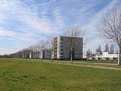
Tanthof is a quarter in the South of Delft, the Netherlands. It was built in the seventies and eighties and consists mainly of low-rise buildings. The area is divided in two parts, Tanthof-East and Tanthof-West.
West and East
Tanthof-West and Tanthof-East were separated on purpose by the old road to Abtswoude, in the South of Delft. These two areas are directly connected to each other only for pedestrians and bicyclists. When the quarter was designed, the architects followed the old creeks. The houses in these two separate areas have very different architectures.
More than half of the houses in Tanthof-East were built for single-family dwellings. About one third of the population lives in a traditional family setting. Tanthof-West is an area with a high amount of young people and young infants. There are three elementary schools and three kindergartens.
The facilities
On the border between East and West is a children's farm with a water playground. There is a tennis court at the 'Straat van Malakka', a sports hall at the 'Fretstraat' and there is a sports complex in the South of Tanthof-East. In Tanthof-East there is a shopping centre at the 'Dasstraat' and Tanthof-West got his shopping area at the 'Bikolaan'. The distance between Tanthof to the centre of Delft is approximately three kilometres and is easily accessible by bicycle. Delft University of Technology is only ten minutes away by bicycle. The Delft Zuid railway station lies next to Tanthof-East.
Trivial
The sand needed for building Tanthof was dug up from the area, now called Delftse Hout. This area is nowadays a recreational area with some lakes.
On January 1, 2005, there were 9100 people registered in Tanthof-West, spread over 3795 houses. In East there live 6624 people in 3160 houses. This is 17% of the total population of Delft.
South to Tanthof is a recreational area called Abtswoudse Bos.
At this moment, the city is building a new community centre.
Coordinates: 51°59′00″N 4°21′44″E / 51.98333°N 4.36222°E