Tanum, Norway
| Tanum, Norway | |
|---|---|
| Village | |
|
Tanum Church | |
| Country | Norway |
| Region | Østlandet |
| County | Akershus |
| Time zone | CET (UTC+01:00) |
| • Summer (DST) | CEST (UTC+02:00) |
.jpg)

Tanum is a parish and district in the municipality of Bærum, Norway. Its population (2007) is 2,751.[1]
Tanum in Bærum is situated on the fertile Tanum plateau which is located approximately 150 meters above sea level. The Tanum area has a rich soil, and is the site of a number of farms. This areas is also known for its archaeological findings of several large burial mounds dating from the Iron Age to the Viking era.[2]
The name
The parish is named after the old farm Tanum (Norse Túnheimr), since the first church was built there. The first element is tún 'country courtyard', the last element is heimr 'homestead, farm'.
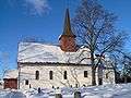
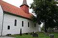
Tanum Church
Tanum Church (Tanum Kirke) was built between 1100 and 1130 in Romanesque architecture style. The building material was brick. During the early 1900s were, the church under went restoration. The church was expanded in 1722 and renovated 1973. The church is of long plan and has 250 number of seats. The church is noted for its plaster art. [3][4]
Gallery
.jpg)
.jpg)
See also
- Tanum Municipality in Sweden.
- Christening in Tanum Church
Notable residents
- philosopher Dagfinn Føllesdal lives in Tanum.
References
- ↑ Population of districts in Bærum – Bærum municipality
- ↑ Svein Askheim. "Tanum i Bærum". Store norske leksikon. Retrieved October 1, 2016.
- ↑ "Tanum kirke, Bærum". Den Norske Kirke. Retrieved October 1, 2016.
- ↑ Sigrid Marie Christie, Håkon Christie. "Tanum kirke". Norges Kirker. Retrieved October 1, 2016.
Coordinates: 59°53′1″N 10°30′13″E / 59.88361°N 10.50361°E