Taoru
| Tauru | |
|---|---|
| Town | |
|
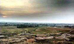
Tauru Landscape | |
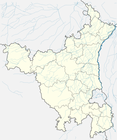 Tauru  Tauru Location in Haryana, India | |
| Coordinates: 28°13′N 76°57′E / 28.22°N 76.95°ECoordinates: 28°13′N 76°57′E / 28.22°N 76.95°E | |
| Country |
|
| State | Haryana |
| District | Gurgaon District |
| Elevation | 262 m (860 ft) |
| Population (2011) | |
| • Total | 22,599 |
| Languages | |
| • Official | Hindi Haryanvi |
| Time zone | IST (UTC+5:30) |
| PIN | 122105 |
| Telephone code | 01267 |
| Vehicle registration | HR |
| Website |
haryana |
Tauru is a town in the Gurgaon District of India's Haryana State.[1]
Geography
Taoru is located at 28°13′N 76°57′E / 28.22°N 76.95°E. It has an average elevation of 262 metres (859 feet). And is surrounded by Aravalli Range from 3 sides.
Demographics
As of 2001 India census,[2] Taoru had a population of 17,227. Males constitute 53% of the population and females 47%. Taoru has an average literacy rate of 86.5%, higher than the national average of 69.5%: male literacy is 87%, and female literacy is 85%. In Taoru, 17% of the population is under 8 years of age.
Education
- Columbia cottage play & primary school
- Hardwarilal Goyal Govt. College
- Chandrawati College
- DPS Mewat Model School
- Government Senior Secondary School
- Hind High School
- Swami Vivekanand Public School
- Chandrawati Senior Secondary School
- Ravindra Public School
- Sarvodaya Public School
- Spring Daisy Convent School
- Holy Child Public School
- GC Model High School (Gopi Chand)
- Govt. Girls Senior Secondary School
- Janta High School
- SD Public School
- MSD Public School (Mhomad Shamsu Din)
- Nancy Modern Public School
- Golden Public School
- Vishwakarma High School
- Green Dales Public High School
Villages Under Taoru
There are Total 84 villages, namely :-
Sikharpur, Buraka, Bhajlaka, Silkho, Chila, Sala-ka, Mala-ka, Mohmadpur, Pethredi, Hasanpur, Panchgaon, Chilawli, Charoda, Masit, Dhelamki, Nurpur, Bawla, Mandarka, Nanuka, Kangarka, Subasedi, Bhogipur, Didhara, Nijampur, Kalarpuri, Raniaki, Sewka, Gunawat, Chundika, Sunari, Khoire, Chote Khoire, Rathiwas, Uton, Jaurasi, Jhamwas, Fatepar, Kalwadi, Pada, Sekhpur, Gudha, Gudhi, Subras, Nanduki, Gogjaka, Goyla, Kalyaki, Sundh, Bhango, Jafrabad, Beri, Chahalka, Kharak Jalalpur, Khad Khadi, Rahadi, Nai Nangla, Dhulawat, Padheni, Khedki, Baghanki, Kota, Bissar, Sarai, Dadu, Dawla Pati, etc.
Images

See also
- [Hassanpur]
References
- ↑ "Taoru (MC)". censusindia.gov.in. Government of India. Retrieved 17 April 2016.
- ↑ "Census of India 2001: Data from the 2001 Census, including cities, villages and towns (Provisional)". Census Commission of India. Archived from the original on 2004-06-16. Retrieved 2008-11-01.
External links
- http://www.maplandia.com/india/haryana/gurgaon/ by sourabh bansal(S.B.), Chicago
- http://secharyana.nic.in/html/PSRESULTPDF/TAORU.pdf by S.B.
- http://secharyana.nic.in/html/MCresultpdf/taoru.pdf by S.B.
- http://haryanatourism.com/pilgrim/surjivanfarm.asp by S.B.
- elections
- MSN Map
- http://heritagetransportmuseum.org/
- http://www.hindustantimes.com/punjab/chandigarh/tauru-turns-into-political-hotspot-as-haryana-assembly-polls-approach/article1-1227595.aspx