Tappan Zee Bridge
| Tappan Zee Bridge | |
|---|---|
 | |
| Coordinates | 41°04′12″N 73°53′28″W / 41.07000°N 73.89111°WCoordinates: 41°04′12″N 73°53′28″W / 41.07000°N 73.89111°W |
| Carries |
7 lanes (3 northbound/westbound, 3 southbound/eastbound, 1 reversible) of |
| Crosses | Hudson River and Hudson Line |
| Locale | Connecting South Nyack, Rockland County, New York and Tarrytown, Westchester County, New York in the Lower Hudson Valley |
| Official name | Governor Malcolm Wilson Tappan Zee Bridge |
| Maintained by | New York State Thruway Authority |
| Characteristics | |
| Design | Cantilever bridge |
| Total length | 16,013 feet (4,881 m) |
| Width | 90 feet (27 m) |
| Longest span | 1,212 feet (369 m) |
| Clearance below | 138 feet (42 m) |
| History | |
| Opened | December 15, 1955 |
| Statistics | |
| Daily traffic | 134,947 (2010)[1] |
| Toll | $4.75 (E-ZPass or Tolls by Mail)[2] (tolled eastbound/southbound only) |
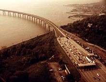
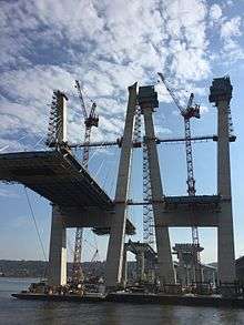
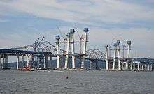
The Governor Malcolm Wilson–Tappan Zee Bridge, usually referred to as the Tappan Zee Bridge, is a cantilever bridge in the U.S. state of New York, crossing the Hudson River at one of its widest points; the Tappan Zee is named for an American Indian tribe from the area called "Tappan"; and zee being the Dutch word for "sea".[3] As an integral conduit within the New York Metropolitan Area, it connects South Nyack in Rockland County with Tarrytown in Westchester County in the Lower Hudson Valley. Federal and state authorities are currently constructing a replacement bridge, the New Tappan Zee Bridge that will cost at least $4 billion.[4]
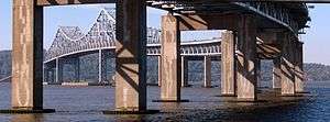
The bridge is part of the New York State Thruway mainline and carries the highway concurrency of Interstate 87 and Interstate 287. The span carries seven lanes of motor traffic. The center lane can be switched between eastbound and westbound traffic depending on the prevalent commuter direction; on weekdays the center lane is eastbound in the morning and westbound in the evening. The switch is accomplished via a movable center barrier which is moved by a pair of barrier transfer machines. Even with the switchable lane, traffic is frequently very slow. The bridge is one of the primary crossings of the Hudson River north of New York City; it carries much of the traffic between southern New England and points west of the Hudson. It is the longest bridge in the State of New York.[5] The total length of the bridge and approaches is 16,013 feet (4,881 m). The cantilever span is 1,212 feet (369 m) providing a maximum clearance of 138 feet (42 m) over the water. The bridge is about 25 miles (40 km) north of Midtown Manhattan, the skyline of which can be seen from the bridge on a clear day.
As of April 2016, each eastbound passenger vehicle that drives under a gantry is charged a toll of $4.75 via E-ZPass, $5.00 by mail, or $3.00 if on the Commuter Plan (which charges a minimum of $60 a month, requiring a minimum of 13 crossings to attain an average cost below the normal E-Z pass rate).[6][7] Westbound crossings are toll-free.[8]
History
With the increasing demands for commuter travel taxing the existing bridges and tunnels, the Port Authority of New York and New Jersey had plans in 1950 to construct a bridge across the Hudson near Dobbs Ferry, New York. The proposal was overridden by New York State Governor Thomas E. Dewey, who wanted to construct a bridge to connect the New York State Thruway across Westchester to the New England Thruway. The Port Authority promised its bondholders that it would not allow any other entity to construct a river crossing within its jurisdiction, which reached to a point one mile (1.6 km) south of Nyack on the western shore of the Hudson River and across to Tarrytown[9] on the eastern shore. The bridge was built on a very tight budget of $81 million (1950 dollars), or $796 million in 2014 dollars.[10]
A May 10, 1950 editorial in The New York Times suggested that a site in southern Dobbs Ferry or northern Hastings-on-Hudson, where the Hudson narrowed considerably from its three-mile (5 km) width at Tappan Zee, would be a more appropriate site, and suggested that Governor Dewey work with his counterpart, Governor of New Jersey Alfred E. Driscoll, to craft a compromise that would offer Thruway customers a discounted bridge fare at a more southerly crossing.[11] Two days later, Governor Dewey announced that the Port Authority had dropped its plans to construct a bridge of its own, and that the bridge's location would be close to the Tarrytown-Nyack line, just outside the Port Authority's jurisdiction. Dewey stated that World War II military technology would be used in the bridge's construction.[12]
The site of the bridge, at the Hudson River's second-widest point, added to construction costs. The site was chosen to be as close as possible to New York City, while staying out of the 25-mile (40 km) range of the Port Authority's influence, thus ensuring that revenue from collected tolls would go to the newly created New York State Thruway Authority, and not the Port Authority.[13][14][15] A unique aspect of the design of the bridge is that the main span is supported by eight hollow concrete caissons. Their buoyancy supports some of the loads and helps reduce costs.[16]
The bridge was designed by Emil Praeger of the Madigan-Hyland engineering firm. Captain Praeger helped develop floating caissons during World War II when the Allied forces needed to create and protect portable harbors for the 1944 invasion of Normandy.[17]
Construction started in March 1952 and the bridge opened to traffic on December 15, 1955, along with a 27-mile (43 km) long section of the New York State Thruway from Suffern to Yonkers.[18][19] New York State Governor W. Averell Harriman signed a bill on February 28, 1956, to officially name the structure the Tappan Zee Bridge.[20] In 1994, the name of Malcolm Wilson was added to the bridge's name upon the 20th anniversary of his leaving the governor's office in December 1974, though it is almost never used when the bridge is spoken about colloquially.[21]
The bridge is expected to be decommissioned in 2016.[22]
Replacement bridge

The deteriorating current structure bears an average of 138,000 vehicles per day, substantially more traffic than its designed capacity. Unlike other major bridges in metropolitan New York, the Tappan Zee was designed to last only 50 years due to material shortages during the Korean War at the time of its construction.[23] The new bridge is intended to last at least 100 years.[24]
The collapse of Minnesota's I-35W Mississippi River bridge in 2007 raised worries about the Tappan Zee's structural integrity.[25] These concerns, together with traffic overcapacity and increased maintenance costs, escalated the serious discussions already ongoing about replacing the Tappan Zee with a tunnel or a new bridge.[26][27] Six options were identified and submitted for project study and environmental review.[28]
In 2009, the Tappan Zee Bridge was featured on The History Channel "The Crumbling of America" showing the infrastructure crisis in the United States.[29] Many factors contribute to the precarious infrastructure of the bridge, which has been called "one of the most decrepit and potentially dangerous bridges" in the U.S.[30] Engineering assessments have determined that "everything from steel corrosion to earthquakes to maritime accidents could cause major, perhaps catastrophic, damage to the span," prompting one of the top aides in the New York state governor's office to refer to the Tappan Zee as the “hold-your-breath bridge.”[30] A 2009 state report noted that the bridge was not built with a plan that was "conducive to long-term durability” and that the Tappan Zee’s engineers designed it to be “nonredundant,” meaning that one "critical fracture could make the bridge fail completely because its supports couldn’t transfer the structure’s load to other supports."[31]
The Metropolitan Transportation Authority (MTA) studied the feasibility of either including a rail line across the new bridge or building the new bridge so a new rail line can be installed at a future date. Commuter rail service west of the bridge in Rockland County is limited, and the MTA studied expansion possibilities in Rockland County that would use the new bridge to connect with Metro-North's Hudson Line on the east side of the bridge along the Hudson River for direct service into Manhattan. On September 26, 2008, New York state officials announced their plan to replace the Tappan Zee Bridge with a new bridge that included commuter-train tracks and lanes for high-speed buses. The bridge was estimated to cost $6.4 billion, while adding bus lanes from Suffern to Port Chester was estimated to cost an additional $2.9 billion. Adding a rail line from the Suffern Metro-North station and across the bridge, connecting with Metro-North’s Hudson Line south of Tarrytown, would have added another $6.7 billion. The plan was reviewed for its environmental impacts.[32]
Meetings by the New York State Department of Transportation with local communities were held in December 2009. They revised the replacement cost including road, rail, and bus up to $16 billion.[33] In 2013, the New York State Thruway Authority began building the New Tappan Zee Bridge, which will be a double-span bridge (four lanes per span in opposite directions) with designated bus lanes. The new bridge is scheduled for completion in 2018.[34]
Suicide prevention
From 1998 to 2008, more than 25 people committed suicide on the Tappan Zee Bridge, according to the New York State Thruway Authority.[35] On August 31, 2007, NYSTA officials added four phones – two each on the Rockland and Westchester sides – that connect callers via the National Suicide Prevention Lifeline crisis hotline to counselors at LifeNet or Covenant House.[36] Signs reading "Life is Worth Living" and "When it seems like there is no hope, there is help" have been placed on the bridge.[37] Suicide fencing and traffic cameras have also been installed along the bridge, and bridge staff have been trained in suicide prevention.[38] An October 14, 2012, Newsday article reports the Tappan Zee Bridge has been referred to as the Golden Gate Bridge of the East, and "The new Tappan Zee, which is in the works, will include fencing designed to thwart jumpers."[39]
The most famous and notorious suicides on the Tappan Zee Bridge are those of Scott Douglas on January 1, 1994, after murdering his wife, Anne Scripps; and on September 24, 2009, of his stepdaughter Annie Morrell Petrillo, who jumped from that same bridge to her death.[40] A US military employee jumped from the bridge to her death in 2010.[41]
See also
References
- ↑ "2010 Traffic Data Report for New York State" (PDF). New York State Department of Transportation. Appendix C. Retrieved 2010-02-27.
- ↑ "Schedule of E-Zpass Tolls at Fixed Toll Barriers". New York State Thruway Authority. Retrieved 2016-04-16.
- ↑ Melvin, Tessa (August 21, 1994). "If You're Thinking of Living In/Tarrytown; Rich History, Picturesque River Setting". The New York Times. Retrieved 2007-12-30.
The Dutch called this point, the river's widest, the Tappan Zee -- Tappan probably for a group of Indians and Zee meaning "sea" in Dutch.
- ↑ Khurram Saeed and Theresa Juva-Brown (2012-12-17). "It's official: State picks builder for new Tappan Zee Bridge". Copyright © 2012 www.lohud.com. All rights reserved. Retrieved 2012-12-19.
- ↑ "Tappan Zee Bridge 1955: Best, Longest, Safest". nyacknewsandviews. Retrieved 5 February 2013.
- ↑ "E-ZPass Commuter Plan". Retrieved 2010-12-24.
If fewer than 20 trips are taken per month, you will be charged $3.00 for each trip not taken.
- ↑ "Schedule of E-Zpass Tolls at Fixed Toll Barriers". New York State Thruway Authority. Retrieved 2016-04-16.
- ↑ "Tappan Zee Bridge". NYC Roads. Retrieved July 28, 2014.
- ↑ Ingraham, Joseph C. (May 7, 1950). "Port Bridge Plan Blocked by Dewey; Peril to Thruway Is Seen in Project at Dobbs Ferry for Link with Jersey Roads". The New York Times. p. 1. Retrieved 2008-07-18.
- ↑ "CPI Inflation Calculator". bls.gov. U.S. Bureau of Labor Statistics. Retrieved 24 September 2014.
- ↑ "That Thruway Bridge". The New York Times. May 10, 1952. p. 1. Retrieved 2008-07-18.
- ↑ Ingraham, Joseph C. (May 12, 1950). "Port Body Gives In on Thruway Span; Accedes to Dewey's Orders and Will Let the Bridge Be Built Wherever His Engineers Say". The New York Times. p. 29. Retrieved 2008-07-18.
- ↑ Brenner, Elsa (April 30, 2000). "Future of Bridge Stirs Bicounty Cooperation". The New York Times. Retrieved 2008-07-18.
The site was selected to be as close to New York City as possible while escaping the 25-mile jurisdiction of the Port Authority of New York and New Jersey, which apparently opposed the bridge because it would compete with the authority's own crossings.
- ↑ Chen, David W. (January 30, 2000). "Ideas & Trends: A Bridge Too Long; The Cost of Urban Sprawl: Unplanned Obsolescence". The New York Times. Retrieved 2008-07-18.
And because it is so long -- built at the Hudson's widest point to escape the 25-mile jurisdiction of the Port Authority of New York and New Jersey -- it is unusually expensive to maintain, repair and, if necessary, replace.
- ↑ Kestenbaum, David (August 19, 2011). "A Big Bridge In The Wrong Place". National Public Radio. Retrieved 2011-08-19.
- ↑ Guide to Civil Engineering Projects In and Around New York City (2nd ed.). Metropolitan Section, American Society of Civil Engineers. 2009. p. 41.
- ↑ Plotch, Philip Mark. Politics Across the Hudson: The Tappan Zee Megaproject. Rutgers University Press, New Jersey (2015). p. 13
- ↑ "Thruway Fact Book" (PDF). New York State Thruway Authority. Retrieved 2010-02-27.
- ↑ "The Thruway Bridge Opens". The New York Times. December 15, 1955. p. 36. Retrieved 2010-02-27.
- ↑ "Tappan Zee Is Official; Governor Signs Bill Naming the Thruway Bridge". New York Times. February 29, 1956. p. 22. Retrieved 2010-02-27.
- ↑ "Mario Just Might Have Been Easier". The New York Times. January 13, 1994. Retrieved 2010-02-27.
- ↑ "Old Tappan Zee Bridge To Be Decommissioned In 2016". CBS News New York. Retrieved 5 February 2013.
- ↑ McGeehan, Patrick (January 17, 2006). "A Bridge That Has Nowhere Left to Go". The New York Times. Retrieved 2010-02-27.
- ↑ "NY proposes steep toll increases for new Tappan Zee bridge". Reuters. 4 August 2012.
Some alternatives to the Tappan Zee bridge are already more expensive. The George Washington Bridge, which crosses the Hudson River south of the Tappan Zee, has a cash toll of US$12, which is expected to rise to $15 in 2015.
- ↑ "Tappan Zee Bridge has received 'poor' ratings". Poughkeepsie Journal. Gannett News Service. August 3, 2007. Retrieved 2008-08-09.
- ↑ Thruway Authority; MTA Metro-North Railroad (June 2003). "Long List of Level 1 Alternatives". Tappan Zee Bridge Replacement. New York State. Retrieved 7 November 2011.
- ↑ Zhao, Yilu (24 July 2003). "From 156 Options, Down to 15 Ways to Go on Tappan Zee". New York Times. Retrieved 7 November 2011.
- ↑ Dept of Transportation; Thruway Authority; MTA Metro-North Railroad (January 2006). "Alternatives Analysis Report, Level 2". Tappan Zee Bridge Replacement. New York State. Retrieved 7 November 2011.
- ↑ "Legislator Day to Appear on History Channel Modern Marvel Series" (PDF) (Press release). June 17, 2009. Retrieved 2010-02-27.
- 1 2 "Falling Down". New York Magazine. January 27, 2013. Retrieved 2013-02-03.
- ↑ "The Tappan Zee Is Falling Down". City Journal. 21 (2). 2011. Retrieved 2013-02-03.
- ↑ Neuman, William (September 26, 2008). "State to Replace, Not Rebuild, Tappan Zee Bridge". The New York Times. Retrieved 2010-02-27.
- ↑ Mayberg, Nathan (December 11, 2009). "$16 billion Tappan Zee replacement will touch Port Chester, Rye Brook". Port Chester Westmore News. Retrieved 2010-02-27.
- ↑ Official New Tappan Zee Bridge Project Site
- ↑ "Authorities Put Anti-Suicide Phones on TZ Bridge". WCBS-TV. August 29, 2007. Archived from the original on 2007-12-22. Retrieved 2008-02-13.
- ↑ Shamburger, Merideth. "Naked Couple Who Jumped From T Z Bridge Identified". The Rivertowns Daily Voice. Retrieved 26 July 2012.
- ↑ Lombardi, Kate Stone (May 11, 2008). "Struggling to Prevent Suicides at Tappan Zee". The New York Times. Retrieved 2010-02-27.
- ↑ Merideth Shamburger, Redmond Zmudzien. "Family Members Tried to Stop Bridge Jumper". The Tarrytown Daily Voice. Retrieved 5 July 2012.
- ↑ TIMOTHY O'CONNOR (14 October 2012). "High anxiety: Trooper fights fear to save would-be Tappan Zee jumpers". Newsday. Retrieved 16 October 2012.
- ↑ Berger, Joseph; Schweber, Nate (September 27, 2009). "As Body Is Found, Efforts to Make Sense of a Loss". The New York Times. Retrieved 2009-12-23.
- ↑ Ryser, Rob; Liebson, Richard; Howard, Brian (June 10, 2010). "Army pvt. bound for Hood jumps from NY bridge". The Journal News. Westchester, NY. Retrieved 2010-06-10.
External links
| Wikimedia Commons has media related to Tappan Zee Bridge. |
- Tappan Zee Bridge at NYCRoads.com
- Tappan Zee Bridge at Structurae
- Tappan Zee Bridge/I-287 Environmental Review project site (archived March 15, 2016)
- Tappan Zee Bridge photos on Flickr
| Crossings of the Hudson River | ||||
|---|---|---|---|---|
| ||||