Taunus
| Taunus | |
|---|---|
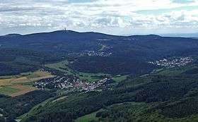 The Hochtaunus with the Feldberg summit | |
| Highest point | |
| Peak | Großer Feldberg (Hochtaunus) |
| Elevation | 878 m (2,881 ft) |
| Coordinates | 50°14′N 08°27′E / 50.233°N 8.450°ECoordinates: 50°14′N 08°27′E / 50.233°N 8.450°E |
| Dimensions | |
| Length | 75 km (47 mi) NE/SW |
| Width | 35 km (22 mi) NW/SE |
| Area | 2,700 km2 (1,000 sq mi) |
| Geography | |
 Taunus | |
| Country | Germany |
| State/Province | Hesse |
| Parent range | Rhenish Slate Mountains |
| Geology | |
| Orogeny | Variscan |
| Age of rock | Devonian |
| Type of rock | Phyllite, Greywacke |
The Taunus is a mountain range in Hesse, Germany located north of Frankfurt. The tallest peak in the range is the 878 m high Großer Feldberg, other notable peaks are the Kleiner Feldberg (825 m) and the Altkönig (798 m).
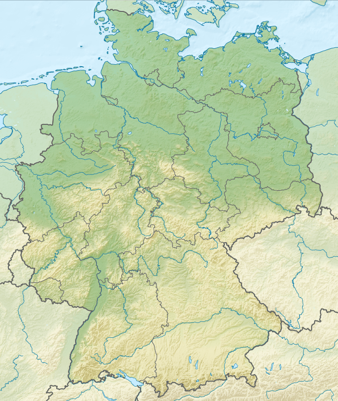
The Taunus range spans the districts of Hochtaunuskreis, Main-Taunus, Rheingau-Taunus, Limburg-Weilburg, and Rhein-Lahn. The range is known for is geothermal springs and mineral waters that formerly attracted members of the European aristocracy to its spa towns. The car line Ford Taunus is named after it.
Description
It is a relatively low range, with smooth, rounded mountains covered with forest. The Taunus is bounded by the river valleys of the Rhine, Main and Lahn rivers and it is part of the Rhenish Slate Mountains. On the opposite side of the Rhine, The Taunus range is continued by the Hunsrück.
For geographical, ecological and geological purposes the Taunus is divided in three parts:
- Pre-Taunus (Vortaunus or Vordertaunus) in the south, next to the cities of Frankfurt am Main and Wiesbaden. This section is mainly made up of old sedimentary rocks with phyllite, greenschist and muscovite. The rocks are often given a greenish hue by the presence of epidote and chlorites.
- High Taunus (Hoher Taunus). The central region of the range where the highest peaks are found. Its geological composition includes slates, quartzite and sandstones.
- Back-Taunus (Hintertaunus) at its northern end is the biggest part by area. The geological materials that compose it include greywacke, claystones and siltstones.
The Taunus range originated during the Devonian period.[1] The geological composition of the mountains was formed in a region covered by an ancient sea that was a few hundred kilometers wide and are mainly made up of phyllite, greenschist, gneiss, slates and sandstone.[2]
Summits
- Großer Feldberg (878 m), Hochtaunuskreis (Kreis = district). Being the highest point in the range, it provides the scenario for the Feldbergrennen hillclimbing and rallying contests. It should not be confused with the Feldberg in the Black Forest
- Kleiner Feldberg (825 m), Hochtaunuskreis. It has an observatory on the summit.
- Altkönig (798 m), Hochtaunuskreis. It has the remains of a late Iron Age hill fort (La-Tène A, ca. 400 BC) near the summit.
- Weilsberg (701 m), Hochtaunuskreis
- Glaskopf (685 m), Hochtaunuskreis
- Pferdskopf (663 m), Hochtaunuskreis
- Kolbenberg (684 m; telecommunication facility), Hochtaunuskreis
- Klingenkopf (683 m), Hochtaunuskreis
- Sängelberg (665 m), Hochtaunuskreis
- Pferdskopf (663 m), Hochtaunuskreis
- Weißeberg (660 m), Hochtaunuskreis
- Fauleberg (633 m), Hochtaunuskreis
- Großer Eichwald (633 m), Hochtaunuskreis
- Roßkopf (632 m; telecommunication facility), Hochtaunuskreis
- Kalte Herberge (619 m), Rheingau-Taunus-Kreis
- Hohe Wurzel (618 m; telecommunication facility), Rheingau-Taunus-Kreis
- Hohe Kanzel (592 m), Rheingau-Taunus-Kreis
- Hallgarter Zange (580 m), Rheingau-Taunus-Kreis
- Erbacher Kopf (580 m), Rheingau-Taunus-Kreis
- Steinkopf (Hochtaunuskreis) (570 m), Hochtaunuskreis
- Kuhbett (526 m), Kreis Limburg-Weilburg at Weilrod-Hasselbach
- Steinkopf (Wetteraukreis) (518 m), Wetteraukreis
History
The Roman Limes was built across the Taunus. The Saalburg, a restored Roman castellum, now houses a museum.
After the fall of the Limes (in 259/260 AD), the Alamanni settled in the range and for this reason there are some Alemannic cemeteries in the southern foothills of the Taunus (Eschborn). This area of the Taunus became part of the Frankish confederation of Germanic tribes after the Battle of Tolbiac around 500 AD.[3]
In past centuries the Taunus became famous among aristocrats for its therapeutic hot springs.[4]
Certain towns in the area, such as Bad Homburg vor der Höhe with its Kurpark, have geothermal spas that were formerly renowned. Other spa towns in the Taunus range are Bad Schwalbach (formerly Langenschwalbach) mentioned in documents dating back to the 16th century, Bad Ems, one of the most reputed therapeutic spas in Germany since the 17th century, as well as Bad Weilbach where a spring reached wide fame for some time. By the 19th century the most famous spa towns in the area were Wiesbaden, Bad Homburg vor der Höhe, Bad Nauheim and Bad Soden am Taunus.[5]
Gallery
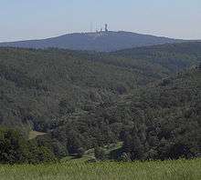
 The Taunus with the Grosser Feldberg viewed from Karben
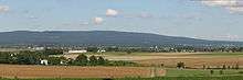 The Winterstein and the tower on the Steinkopf from Karben
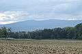 View (from top of Frankfurt) of Altkoenig and Grosser Feldberg
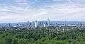 Frankfurt am Main, with the Taunus Mountains in the background
References
- ↑ Zur geologischen Entstehung des Taunus (German)
- ↑ Geologische Highlights im Geopark Westerwald-Lahn-Taunus (German)
- ↑ Egon Schallmayer et al. (eds.) Die Römer im Taunus. Frankfurt a. M. 2005, ISBN 3797309554 (German)
- ↑ "Great Spas of Europe". UNESCO. Retrieved 10 March 2016. Lists Bad Ems, Bad Homburg vor der Höhe, and Wiesbaden among the 16 in total.
- ↑ Heinz Biehn, Der Taunus. Hohe Wälder, weite Täler, warme Quellen. Amorbach 1972 (German)
External links
-
 Media related to Taunus at Wikimedia Commons
| Look up Taunus in Wiktionary, the free dictionary. |
| Wikivoyage has a travel guide for Taunus. |
- There is literature about Taunus in the Hessian Bibliography
- Umweltatlas Hessen: → Natur und Landschaft → Die Naturräume Hessens bzw. Naturräumliche Gliederung – Naturraum-Haupteinheit 30 (Taunus), auf atlas.umwelt.hessen.de
- Fremdenverkehrsinformationen, Taunus Tourist Service at taunus.info
- Taunus Nature Park at naturpark-taunus.de
- Feldberg Roman Fort circular path, at feldbergkastell.de
- Der Taunus und seine Landschaften, 3D overview maps of the countryside of the Taunus at geocortex.de
- Summits in the Taunus by isolation and prominence, at thehighrisepages.de
- Wehrheim, das Tor zur Bronzezeit im Usinger Land, Infos zu archäologischen Funden in Wehrheim, auf geschichtsverein-usingen.de
- Das Vortaunusmuseum at vortaunusmuseum.de
- map and aerial photo of the Taunus with boundaries, rivers and all important summits (Google Earth), at geographie.giersbeck.de#Taunus Placemarks

Subdivisions of the Rhenish Massif | ||
|---|---|---|
 | ||