Zittau Mountains
| Zittau Mountains (Zittauer Gebirge) | |
|---|---|
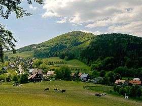 View over Waltersdorf to the Lausche | |
| Highest point | |
| Peak | Lausche |
| Elevation | 792.6 m (2,600 ft) |
| Geography | |
| State |
Görlitz, Saxony, |
| Range coordinates | 50°51′N 14°39′E / 50.85°N 14.65°ECoordinates: 50°51′N 14°39′E / 50.85°N 14.65°E |
| Parent range | Lusatian Mountains (cross-border range) and the overarching Saxon Highlands and Uplands (GE) |
The Zittau Mountains (German: Zittauer Gebirge), formerly also called the Lusatian Ridge (Lausitzer Kamm, Czech. Žitavské hory), refer to the German part of the Lusatian Mountains that straddle the Saxon-Bohemian border in the extreme southeast of the German state of Saxony.
Geography
Location
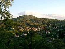
The Zittau Mountains lie in the extreme south of the district of Görlitz in Saxony. A few kilometres north of the range lie a number of settlements; from west to east they are Großschönau, Hainewalde, Olbersdorf, Bertsdorf-Hörnitz and Zittau. In the mountains themselves are, again from west to east, the settlements of Waltersdorf, Oybin, Jonsdorf and Lückendorf . The highlands are drained by streams that flow roughly north into the Mandau, a western tributary of the Lusatian Neisse.
Mountains
Among the highest mountains in the range are the following (in order of height in m above NN:[1]
- Lausche (Luž; 792.6 m), German-Czech border mountain, south of Waltersdorf
- Hochwald (Hvozd; 749.5 m), German-Czech border mountain, south-southwest of Oybin
- Jonsberg (652.9 m), east-southeast of Jonsdorf
- Buchberg (651.6 m), west of Jonsdorf
- Scharfenstein (569.4 m), east of Oybin, north-northwest of Lückendorf
- Breiteberg (510.1 m), east of Großschönau, south of Hainewalde
- Oybin (514.5 m), north of Oybin
- Töpfer (582 m), northeast of Oybin, south of Olbersdorf
Places of interest
- Oybin mountain with castle and monastery ruins
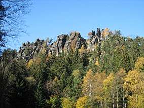
- Mühlsteinbrüche, rock formations in Jonsdorf
- Große Felsengasse ("Great Rock Alley")
- Töpfer mountain
- Lausche (792.6m), the highest summit in the Zittau Mountains
- Breiteberg
- Scharfenstein
- Orgel (organ) - a rock formation in the Jonsdorfer Felsenstadt
- Kelchstein ("Chalice Rock") a mushroom rock formation
- Nonnenfelsen ("Nun's Rock") near Jonsdorf
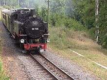
- Zittau Narrow Gauge Railway
- Lusatian timber-frame farmhouses (Umgebindehäuser), especially in Waltersdorf, Jonsdorf and Bertsdorf
See also
References
- ↑ Map services Archived December 19, 2012, at the Wayback Machine. of the BfN
General sources
- BfN
- Map services
- Landscape fact file Zittau Mountains
Literature
- Peter Rölke (Hrsg.): Wander- & Naturführer Zittauer Gebirge, Berg- & Naturverlag Rölke, Dresden 2006, ISBN 3-934514-17-0
External links
- Zittau Mountains
- private website about the mountains
- Mountain biking in the Zittau Mountains
- Digital climbing guide to the Zittau Mountains
- Lusatian Mountains
