Tavarnelle Val di Pesa
| Tavarnelle Val di Pesa | ||
|---|---|---|
| Comune | ||
| Comune di Tavarnelle Val di Pesa | ||
|
Pieve of San Pietro in Bossolo. | ||
| ||
 Tavarnelle Val di Pesa Location of Tavarnelle Val di Pesa in Italy | ||
| Coordinates: 43°33′N 11°10′E / 43.550°N 11.167°ECoordinates: 43°33′N 11°10′E / 43.550°N 11.167°E | ||
| Country | Italy | |
| Region | Tuscany | |
| Province / Metropolitan city | Florence (FI) | |
| Frazioni | Badia a Passignano, Sambuca Val di Pesa, San Donato in Poggio | |
| Government | ||
| • Mayor | Sestilio Dirindelli (Democratic Party) | |
| Area | ||
| • Total | 57.0 km2 (22.0 sq mi) | |
| Elevation | 378 m (1,240 ft) | |
| Population (1 January 2007)[1] | ||
| • Total | 7,346 | |
| • Density | 130/km2 (330/sq mi) | |
| Demonym(s) | Tavarnellini: Frazioni: Sambuchini, Sandonatini | |
| Time zone | CET (UTC+1) | |
| • Summer (DST) | CEST (UTC+2) | |
| Postal code | 50028 | |
| Dialing code | 055 | |
| Patron saint | St. Lucy | |
| Saint day | December 13 | |
| Website | Official website | |
Tavarnelle Val di Pesa is a comune (municipality) in the Province of Florence in the Italian region Tuscany, located about 25 kilometres (16 miles) south of Florence.
Main sights
The main attraction of the territory of Tavarnelle is the Badia di Passignano (Abbey of Passignano), a monastery existing from the High Middle Ages.[2]
Other sights include:
- Church of Santa Lucia al Borghetto, part of a Franciscan monastery known from 1260. The church is an example of Gothic architecture.
- Gothic church of Madonna della Neve, with 14th-15th-century frescoes.
- Church of Santa Maria del Carmine al Morrocco (15th century)
- Sanctuary of Santa Maria delle Grazie a Pietracupa, founded in 1596, with a Madonna image frescoed by Paolo Schiavo.
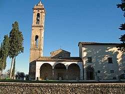
- Pieve of San Pietro in Bossolo, a Romanesque church known from 990, housing works from Roman, Byzantine and Florentine schools.
- Villa di Poggio Petroio, outside the town.
- The pieve of San Donato in Poggio (12th century), in Romanesque style, with a basilica plan with a nave and two aisles and three apses. It houses a baptism shell by Giovanni della Robbia (1513) and a triptych by Giovanni del Biondo (1375).
- Bridge over the Pesa River in the frazione of Sambuca.
Tignano is a fortified hamlet whose church of San Romolo houses a terracotta tabernacle by Giovanni della Robbia.
References
- ↑ All demographics and other statistics: Italian statistical institute Istat.
- ↑ Hornik, Heidi J. (2009). Michele Tosini and the Ghirlandaio Workshop in Cinquecento Florence. Sussex Academic Press. p. 56. ISBN 978-1-84519-186-3.
External links
| Wikimedia Commons has media related to Tavarnelle Val di Pesa. |
This article is issued from Wikipedia - version of the 3/3/2016. The text is available under the Creative Commons Attribution/Share Alike but additional terms may apply for the media files.