Te Aroha
| Te Aroha | |
|---|---|
| Minor urban area | |
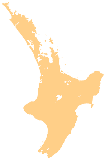 Te Aroha Te Aroha's location within the North Island | |
| Coordinates: 37°32′S 175°43′E / 37.533°S 175.717°ECoordinates: 37°32′S 175°43′E / 37.533°S 175.717°E | |
| Country | New Zealand |
| Region | Waikato |
| Territorial authority | Matamata-Piako District |
| Population (June 2016)[1] | |
| • Total | 4,250 |
| Postcode(s) | 3320 |

Te Aroha is a rural town in the Waikato region of New Zealand with a population of 3,906 people in the 2013 census, an increase of 138 people since 2006.[2] It is 53 km northeast of Hamilton and 50 km south of Thames. It sits at the foot of 952-metre Mount Te Aroha, the highest point in the Kaimai Range.
History
The name Te Aroha comes from the Māori name of Mount Te Aroha. In one version, Rāhiri, the eponymous ancestor of Ngāti Rāhiri Tumutumu, climbed the mountain and saw his homeland in the distance and felt a sense of love (aroha) for it. The name is often rendered in English as "place of love".
On 17 February 1985 Te Aroha experienced a severe flash flood that washed boulders, mud, and trees through the town. Most shops and more than 50 homes were damaged, resulting in the death of three people.[3][4][5]
Geography
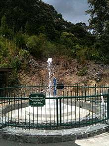
The Waihou River runs through Te Aroha. Close by to the east is the base of the Kaimai Range, and the town is overlooked by the 952-metre Mount Te Aroha. To the north of the town is the low-lying, swampy land of the Hauraki Plains. Thermal and mineral springs are both found close to the centre of the town, as is the world's only hot soda water geyser. See Attractions
Economy
Te Aroha is at the centre of a dairy farming community and much of its economic activity is in serving that community. Tourism is increasing in Te Aroha. The mineral baths are a very popular spot for tourists and locals alike.
Historically mining played a role in the area, and has left some legacies – not all of them positive, such as toxic residues leaking from the abandoned Tui mine tailings dam.[6]
Attractions
Te Aroha is the location of the Mokena Hou Geyser, the only natural soda water geyser in the world.[7] The geyser is located in the Te Aroha Domain, the oldest intact Edwardian domain in New Zealand.[8]
The Hauraki Rail Trail has recently (2012) been opened, connecting the town to Paeroa and beyond.
Events
- Waihou and Te Aroha Cobras play an annual rugby match for the Dr Dunn memorial trophy. This is one of the biggest days on the calendar of Te Aroha.
- A Day in the Domain was started in Te Aroha in 1977 by the Arts Council and continues to be a fun, affordable day out. The day attracts artists and performers from far and wide with a variety of stalls and foodies on display. Entertainment is free with competitions and games all day.
- The King and Queen of the Mountain and Bald Spur Derby have been annual events in Te Aroha since the 1950s. Held the weekend before Christmas, the challenge is to be the first man or woman up Mt Te Aroha and back down again. This has been achieved in under one hour. The Bald Spur Derby offers competitors a shorter but still challenging course.
- Te Aroha AP & H Show has been running since the 1890s. Boasting one of the most extensive home industries sections, it has full agricultural and equestrian sections and the usual country fair activities such as the gumboot throwing competition and cattle dogs.
Notable people
- Olympic Gold Medalist Peter Snell
- All Blacks Don Clarke, Kevin 'Herb' Schuler, Carl Hoeft, Keith Robinson and Kevin O'Neill
- Ian S. Ardern of the First Quorum of the Seventy of The Church of Jesus Christ of Latter-day Saints was born in the town
- Robert Coulter, Mayor of Te Aroha and Labour MP
- David Cunliffe, former leader of the New Zealand Labour Party, was born in Te Aroha.
- Stuart Farquhar, Olympic javelin thrower
- Jack Body, New Zealand composer
- Don Beard, New Zealand cricketer and principal of Te Aroha College from 1961 to about 1982
References
- ↑ "Subnational Population Estimates: At 30 June 2016 (provisional)". Statistics New Zealand. 21 October 2016. Retrieved 21 October 2016. For urban areas, "Subnational population estimates (UA, AU), by age and sex, at 30 June 1996, 2001, 2006-16 (2017 boundary)". Statistics New Zealand. 21 October 2016. Retrieved 21 October 2016.
- ↑ 2013 Census QuickStats about a place:Te Aroha
- ↑ "Case Study: Te Aroha Flood, 1985". Matamata Piako District Council. Retrieved 22 January 2014.
- ↑ McSaveney, Eileen (9 July 2013). "Debris from a flash flood". Te Ara - the Encyclopedia of New Zealand.
- ↑ "The day disaster arrived". Stuff. Retrieved 2015-12-24.
- ↑ Cumming, Geoff (6 March 2010). "Miners press to enter the green zone". The New Zealand Herald. Retrieved 26 March 2010.
- ↑ http://www.mpdc.govt.nz/our-community/walking-a-cycling-tracks/te-aroha-walking-tracks/mokena-geyser-access.html Mokena Hou section of the MPDC website
- ↑ http://www.mpdc.govt.nz/our-facilities/te-aroha-domain.html Te Aroha Domain section of the MPDC website
External links
| Wikimedia Commons has media related to Te Aroha. |
- Te Aroha i-SITE Visitor Centre
- Te Aroha Museum Website
- Te Aroha section of the MPDC website
- Te Aroha College