Whangape Harbour
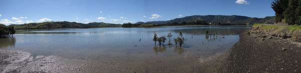
Whangape Harbour is a harbour on the west coast of Northland, New Zealand. There is a settlement also called Whangape on the northern side of the harbour, and another called Pawarenga on the southern side. The Herekino Harbour and settlement are a few kilometres to the north, and the Hokianga is to the south and east.[1][2] Kaitaia is 42 km north east.[3]
The harbour is a narrow valley from the confluence of the Awaroa and Rotokakahi Rivers through hills to the Tasman Sea.[4] The harbour entrance is treacherous.[3]
History
According to Māori traditions, the waka Māmari, captained by Ruānui, settled the Whangape area after being forced out of the Hokianga during early Māori settlement of New Zealand.[5] They established a large fortified pa at Pawarenga. Here they were attacked by a war party from the south, which greatly outnumbered them. The Ngāti Ruānui stacked brushwood about the pa, and set them alight before fleeing across the harbour on rafts, hidden by the clouds of smoke produced. They settled much of the far north, becoming known as Te Aupōuri ('au' means current and 'pōuri' smoke) after this event.[6][7]
Edward Wakefield described the harbour in 1837, and estimated the local Māori population as "not fewer than one thousand souls".[8]
Whangape settlement became an important timber port in the late 19th and early 20th century. There was a large mill on the foreshore and numerous houses on the hills. Ships, initially sailing ships and later steamers, loaded the kauri timber and transported it to markets elsewhere. At least four ships were wrecked at the harbour entrance: the 79-ton schooner Leonidas in 1871,[9] the 15-ton cutter Lionel in 1877 with all five on board lost,[10] the 108-ton schooner Geelong in 1879 with two lives lost,[11] and most recently the River Hunter foundered in 1906 while under tow.[12]
Education
Te Kura o Hata Maria o Pawarenga is a coeducational full primary (years 1-8) school. It has a decile rating of 2 and a roll of 26.[13]
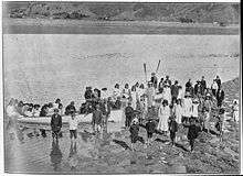
Rotokakahi Native School (also called Rotokakahi Maori School) operated from 1918 to about 1969 on the harbour.[14]
References
- ↑ Peter Dowling (editor) (2004). Reed New Zealand Atlas. Reed Books. pp. map 3. ISBN 0-7900-0952-8.
- ↑ Roger Smith, GeographX (2005). The Geographic Atlas of New Zealand. Robbie Burton. pp. map 18. ISBN 1-877333-20-4.
- 1 2 "Kaitāia and district". Te Ara Encyclopedia of New Zealand.
- ↑ Parkes, W. F. (c. 1965). The Visitors' Guide to the Far North - Mangonui County (3rd ed.). p. 12.
- ↑ "Canoe traditions - Canoes of the northern tide". Te Ara Encyclopedia of New Zealand.
- ↑ "Te Aupōuri and Te Rarawa". Te Ara Encyclopedia of New Zealand.
- ↑ Parkes, pp 12-13
- ↑ Wakefield, Edward Jerningham (1837). The British Colonization of New Zealand. pp. 88–89.
- ↑ "New Zealand Historical Data: Name Index - Ships L".
- ↑ "New Zealand Historical Data: Name Index - Ships L".
- ↑ "New Zealand Historical Data: Name Index - Ships G".
- ↑ Parkes, p 13
- ↑ "Te Kete Ipurangi - Te Kura o Hata Maria o Pawarenga". Ministry of Education.
- ↑ "Broadwood Area School (X366)".
| Wikimedia Commons has media related to Whangape Harbour. |
Coordinates: 35°21′0″S 173°14′0″E / 35.35000°S 173.23333°E