Tegal, Central Java
| Tegal | ||
|---|---|---|
| ||
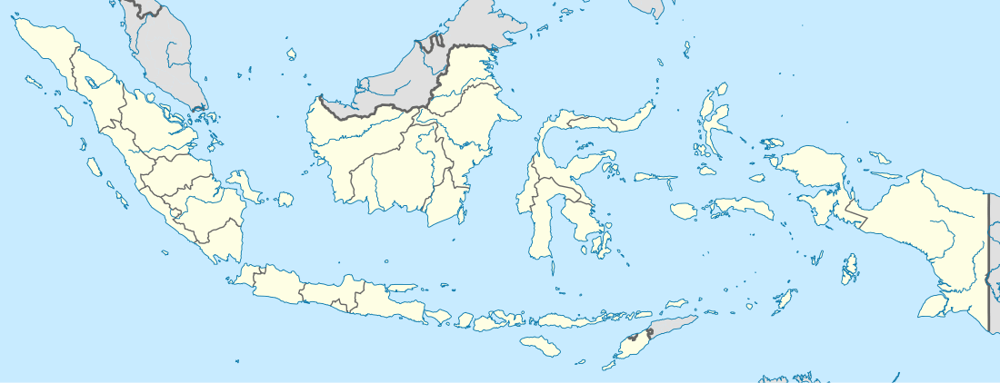 Tegal Location of Tegal in Indonesia | ||
| Coordinates: 6°52′S 109°8′E / 6.867°S 109.133°E | ||
| Country | Indonesia | |
| Province | Central Java | |
| Area | ||
| • City | 39.68 km2 (15.32 sq mi) | |
| • Metro | 564 km2 (218 sq mi) | |
| Population (2010 census) | ||
| • City | 239,599 | |
| • Density | 6,000/km2 (16,000/sq mi) | |
| • Metro | 1,366,858 | |
| • Metro density | 2,400/km2 (6,300/sq mi) | |
| Time zone | WIB (UTC+7) | |
| Website | (Official Website) and (Discussion Forum) | |
Tegal is a large city in the northwest part of Central Java Province of Indonesia. It is situated on the north coast of Central Java, about 175 kilometres (109 mi) from Semarang, the capital of the province. It had a population of 239,599 at the 2010 Census, but the latest official estimate (as at 2014) is 242,539. Its built-up (or metro) area made of Tegal Municipality and 12 districts spread on Tegal and Bremes regencies was home to 1,366,858 inhabitants as of 2010 census.[1] It is administratively separate from Tegal Regency, which borders it to the south and east; Brebes Regency borders it to the west.
The Dutch East Indies colonial sugar industry originated in Tegal and the nearby city of Pekalongan, approximately 50 kilometres (31 mi) to the east. Tegal Regency remained a major sugar production center until the mid-20th century.[2] The city served as a port for exporting sugar produced on the nearby plantations. Tegal is famous for its warung, commonly called "warteg" or warung tegal. It is also known for its tea products, such as teh botol Sosro, Tong Tji tea, 2 Tang tea, Gopek tea and other brands.
History

The city of Tegal developed from a small village called Tetegual. The modernization of the village began in the early 1530s, and it eventually became part of the Pekalongan Regency, which admitted the existence of the Pajang Empire in Central Java. The Pajang Empire was the successor of the Sultanate of Demak.
The city was founded by Ki Gede Sebayu. Together with the local people, he aspired to increase the region’s agriculture, exploiting its fertile soil. Because of his efforts to develop the region, he became the high leader and the symbol of the city. His coronation as leader was held simultaneously with a traditional festival celebrating a rich agricultural harvest. In accordance with district ordinance no. 5/1988, July 28 is the anniversary of the city of Tegal.
In the 1920s, the city was a center of activism for the Communist Party of Indonesia (PKI), and the radical leaders of the Tegal branch of the PKI were among the instigators of the 1926 rebellion that led to the temporary destruction of that party.[3]
On October 8, 1945, an anti-feudalism movement called Gerakan Tiga Daerah ("Three Regions Movement") was established in Tegal, Pekalongan, and Brebes. Its goal was to replace the blue-blood regents (related to the kings of Yogyakarta and Surakarta) with ordinary people. According to the leaders of this movement, the old regents had cooperated with the Japanese during the world war II and sent people to Japanese slave labor camps. The main leader of Gerakan Tiga Daerah was Sarjiyo, who became the new regent of Pekalongan. Others were Kutil, K. Mijaya and Ir. Sakirman. Ir Sakirman was the local leader of the PKI. The government of the Republic of Indonesia in Yogyakarta opposed Gerakan Tiga Daerah and declared it illegal.
Gerakan Tiga Daerah had the old regents arrested, stripped naked and dragged into prison. Other government officials and police officers were kidnapped and massacred at Talang bridge. The Gerakan Tiga Daerah also started a racial riot against ethnic Chinese in Brebes. On November 4, 1945, the movement attacked the Indonesian army headquarters and the regent office in Pekalongan. The rebels were defeated by the Indonesian army in a fierce battle on December 21, 1945, and most of their leaders were arrested and imprisoned. This rebellion is called the Three Regions Affair.
During the unrest following the resignation of President Suharto in 1998, Tegal was the site of extensive protests and occasional violence against local government officials, especially in June 1998.
Climate
| Climate data for Tegal | |||||||||||||
|---|---|---|---|---|---|---|---|---|---|---|---|---|---|
| Month | Jan | Feb | Mar | Apr | May | Jun | Jul | Aug | Sep | Oct | Nov | Dec | Year |
| Average high °C (°F) | 29 (84) |
29 (84) |
29 (85) |
30 (86) |
31 (87) |
30 (86) |
30 (86) |
30 (86) |
31 (87) |
31 (87) |
31 (87) |
30 (86) |
30 (86) |
| Average low °C (°F) | 24 (76) |
24 (76) |
24 (76) |
25 (77) |
25 (77) |
24 (76) |
23 (74) |
23 (74) |
24 (76) |
25 (77) |
25 (77) |
24 (76) |
24 (76) |
| Average precipitation mm (inches) | 350 (13.78) |
300 (11.81) |
250 (9.84) |
120 (4.72) |
130 (5.12) |
80 (3.15) |
50 (1.97) |
40 (1.57) |
30 (1.18) |
50 (1.97) |
110 (4.33) |
240 (9.45) |
1,810 (71.26) |
| Source: [4] | |||||||||||||
Language
Tegal has its own language, known as Bahasa Tegal. Some Indonesian comedians speak it because its accent and dialect arouse amusement. The greeting "How are you?" translates to "Kepriben kabare?"
Slang
It is common practice for people in Tegal to call their friends "Jon", "Jack" or "Jakwir". The translation for "Daddy" is Jasak, "Mommy" is Jok, a younger brother is addressed as Yarig and an older brother as Sahang. Many other words can only be understood by native Tegals. Bahasa Tegal also has many Arabic loan words.
Interesting places and buildings
- Gunung Guci: natural sulfur waterfalls for healing many skin diseases;
- Pantai Alam Indah (PAI): a famous beach in Tegal;
- Alun-alun Tegal: in front of Mesjid Agung Tegal mosque;
- Pasar Pagi Tegal: the biggest market in Tegal;
- Bird Market: in Pasar Senggol next to Alun-alun area;
- Taman Poci: a small park with children's playground and picnic area in front of the station, with kiosks selling exotic foods and Teh Poci tea;
- Tegal railway station: connecting many other big cities in Java.
Notable people
- Suswono (1959–), politician
- Simon Santoso (1982-), badminton player
References
- ↑ http://www.citypopulation.de/php/indonesia-jawa-admin.php
- ↑ Knight, G.R. (1993) Colonial Production in Provincial Java. The Sugar Industry in Pekalongan-Tegal, 1800-1942. Amsterdam: VU University Press.
- ↑ McVey, Ruth. (1965) The rise of Indonesian communism. Ithaca, NY: Cornell University Press. pp 329-340.
- ↑ http://www.weatherbase.com/weather/weather.php3?s=079769&refer=&cityname=Tegal-Jawa-Tengah-Indonesia
External links
| Wikimedia Commons has media related to Tegal. |
- (Indonesian) Military History Centre/Three regions affair
- (Indonesian) Military History Centre/Battle on December 21, 1945
Coordinates: 6°52′S 109°8′E / 6.867°S 109.133°E
Regencies and cities of Central Java | ||
|---|---|---|
Capital: Semarang | ||
| Regencies |  | |
| Cities | ||
| Villages | ||