Teluk Bahang
| Teluk Bahang 直落巴巷 | |
|---|---|
| Town | |
|
Teluk Bahang Dam | |
 Teluk Bahang Location in Peninsular Malaysia | |
| Coordinates: 5°27′0″N 100°13′0″E / 5.45000°N 100.21667°E | |
| Country | Malaysia |
| State | Penang |
| District | South-West Penang Island |
| Government | |
| • Local Government | Penang Island City Council (MBPP) |
| • Penang Island City Mayor | Dato' Patahiyah binti Ismail |
| • Balik Pulau Member of Parliament | Hilmi bin Yahya (UMNO) |
| • Teluk Bahang State Assemblyman | Shah Haedan bin Ayoob Hussain Shah (UMNO) |
| Time zone | MST (UTC+8) |
| • Summer (DST) | Not observed (UTC) |
| Postal code | 11050 |
| International dialling code prefix | +604 (landline only) |
| Website | http://www.mbpp.gov.my |

Teluk Bahang is a small town in Southwest Penang Island District, Penang, Malaysia. The Teluk Bahang Dam is situated here. Teluk Bahang is also the entry point for the Penang National Park, which was previously known as the Pantai Aceh Forest Reserve.
It is between Batu Feringgi and Pantai Acheh in Penang.
The most beautiful and expensive Mutiara Beach Resort is located just outside Teluk Bahang village and it is the last hotel along the beach hotel road in Penang. A batik factory is found here.
The Jalan Teluk Bahang starts from the Parkroyal Hotel, Penang. It has a Chinese primary school in Teluk Bahang. Teluk Bahang is also has a monkey bay. Among the town linking with Teluk Bahang is Muka Head. There is a lighthouse in Muka Head.
Local Attractions
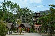
- ESCAPE Adventureplay Theme Park
Latest tourist attraction in Penang Island opened in 2012 created by Sim Leisure.
- Hock Lok Siew Durian Estate
- Jubilee Camp Beach
- Monkey Beach (Teluk Duyung)
A quiet beach located within Penang National Park.
- Muka Head Lighthouse
14m-high lighthouse built by the British in 1883 on top of a hill at an elevation of 223m within Penang National Park. It can be reached by hiking from Monkey Beach. [1]
- Penang Butterfly Farm
First butterfly farm in the tropical region opened in 1986 which is home to more than 4000 butterflies from 120 different species, including the rare Indian Leafl (Kallima paralekta), the endangered Yellow Bird wing (Troides helena) and Rajah Brooke's Bird wing. [2]
- Penang National Park
- Taman Rimba Teluk Bahang
A 32-hectare forest park with streams, waterfalls and hiking trails which is a popular camping and picnic ground for families.
- Teluk Awak Beach
- Teluk Bahang Dam
Largest dam in Penang Island.
- Tropical Fruit Farm
Food
- End of the World Seafood Restaurant
Coordinates: 5°27′N 100°13′E / 5.450°N 100.217°E