Penang Bridge
| |
|---|---|
| Penang Bridge | |
| Route information | |
|
Maintained by PLUS Malaysia Berhad with its subsidiary Projek Lebuhraya Usahasama Berhad (Former concessionaries known as Penang Bridge Sdn Bhd (PBSB)) | |
| Length: | 13.5 km (8.4 mi) |
| Existed: | 1970's – present |
| History: | Opened 3 August 1985, inaugurated 14 September 1985[1] |
| Major junctions | |
| East end: |
|
|
| |
| West end: |
|
| Location | |
| Primary destinations: | George Town, Bayan Lepas, Perai, Butterworth, Bukit Mertajam |
| Highway system | |

| Penang Bridge Jambatan Pulau Pinang 槟威大桥 பினாங்கு பாலம் | |
|---|---|
 | |
| Carries | Motor vehicles |
| Crosses | Selatan Strait, Malaysia |
| Locale | Penang |
| Official name | Penang Bridge |
| Maintained by |
PLUS Malaysia Berhad with its subsidiary Projek Lebuhraya Usahasama Berhad (Former concessionaries known as Penang Bridge Sdn Bhd (PBSB)) |
| Characteristics | |
| Design |
cable-stayed bridge box girder bridge |
| Total length | 13.5 km (8.4 mi) |
| Width | -- |
| Longest span | 225 m |
| History | |
| Designer |
Primary Government of Malaysia Malaysian Highway Authority Secondary United Engineers Malaysia Berhad |
| Constructed by |
Primary Package 1 Loh & Loh Construction Co Ltd Package 2 Maraputra Sdn Bhd Package 3, 4 and 5 Sykt. Pembinaan Hashbuddin (M) Sdn. Bhd. (Joint Venture) Lim Kar Bee & Sons Sdn. Bhd. (Joint Venture) United Engineers Malaysia Berhad Package 6 and 7 Sykt Pembinaan Rahim & Sons Sdn. Bhd. Secondary Howard Needles & Tammen, Bergendoff Intl. Inc. SA/JK(SEA) (Consulting Engineer) |
| Construction begin | 1982[1] |
| Construction end | 1985[1] |
| Inaugurated | 14 September 1985[1] |
| Opened | 3 August 1985 |
| Statistics | |
| Toll | Depends on vehicle type (island-bound only) |
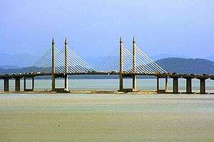
The Penang Bridge (Malay: Jambatan Pulau Pinang; Chinese: 槟威大桥; pinyin: Bīn-Wēi dà qiáo; Tamil: பினாங்கு பாலம்), route E36, is a 13.5-kilometre (8.4-mile)[2][3] dual carriageway toll bridge and controlled-access highway in the state of Penang, Malaysia. The bridge connects Perai on the mainland side of the state with Gelugor on the island, crossing the Selatan Strait. The bridge was the first and, until 2014, the only road connection between the peninsula and the island. The bridge is the second-longest bridge in Malaysia and the fifth-longest in Southeast Asia by total length, with a length over water of 8.4 kilometres (5.2 miles).[3]
The bridge was inaugurated on 14 September 1985.[1] The current concession holder and maintainer of the bridge is PLUS Expressways. Penang Bridge Sdn Bhd was the concession holder before it was merged with the current concessionaire.
Route description
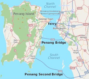
The route begins at the Penang Bridge interchange with the North–South Expressway Northern Route and Jalan Perusahaan Perai. The route then briefly goes southwest, where island-bound commuters proceed to pay the bridge toll. At the shore where the bridge begins, the route turns westwards, crossing the Selatan Strait. In the middle of the bridge, the route bends slightly northwest towards Gelugor. On the island side, the route ends at the shore at its interchange with the Tun Dr Lim Chong Eu Expressway and the Gelugor Highway.[4]
History
Planning
Before 1985, transportation between the island and the mainland was solely dependent on the state-owned Penang Ferry Service that runs between Butterworth and George Town.
In the early 1970s, the idea to build a bridge linking Seberang Perai to Penang Island was suggested by the 2nd Prime Minister of Malaysia's Tun Abdul Razak and the 2nd Chief Minister of Penang's Tun Dr Lim Chong Eu.
At the end of 1971, the Malaysian government appointed Christiani Nielsen A/S of Denmark to carry out a feasibility study.
In the year 1976, Penang Bridge was planned during the term of 3rd Prime Minister of Malaysia's Tun Hussein Onn.
In November 1976, Howard Needles Tammen & Bergendorf of United States in association with Jurutera Konsultant (SEA) Sdn. Bhd. of Malaysia was appointed to design and supervise the construction of the bridge.
On 23 July 1981, Works Minister of Malaysia's Dato Seri Samy Vellu announced that Penang Bridge, Penang would be constructed using the cable-stayed concrete girder of the San Francisco's Golden Gate Bridge instead of the steel-tied arch in the style of the Sydney Harbour Bridge.
Construction
In 1982, the construction of Penang Bridge officially began. The bridge was constructed by the Hyundai Engineering and Construction Company (Korea) Ltd from South Korea and the United Engineers Malaysia Berhad. During construction, a two-man made island at South Channel was created for the construction of the cable stayed bridge and the Gelugor coastline was reclaimed into cape for the construction of the Gelugor interchange.
Opening
On 3 August 1985, the Penang Bridge was officially opened by the 4th Prime Minister of Malaysia's Tun Dr. Mahathir Bin Mohamad. He drove across the bridge in a red Proton Saga (the national car), carrying the national flag to officiate the opening ceremony. On 14 September 1985, Penang Bridge is officially opened to traffic by the fourth Yang di-Pertua Negeri (Governor) of Penang, Tun Dr. Awang Hassan.
Penang Bridge Widening Project
When the bridge was constructed, the central span had six lanes, while the rest of the bridge had four lanes. There was an ongoing project to have the entire bridge widened to six lanes. Work on the project began on January 2008 and was completed in late 2009.
Bridge specifications[5]


- Overall Length: 13.5 km (8.4 mi)
- Length Over Water: 8.4 km (5.2 mi)
- Penang Island Viaduct & Approach: 1.5 km (0.93 mi)
- Prai Approach: 3.6 km (2.2 mi)
- Carriageway: 3 lanes per carriageway
- Height of Tower Above Water: 101.5 m
- Height of Bridge Above Water: 33 m
- Main Span: 225 m
- End Span: 107.5 m
- Other Span: 40 m
- Speed limit: 80 km/h
- Maximum Gradient: 3.0%
Features
The bridge has an emergency layby equipped with SOS phone. Traffic CCTV and Variable Message Sign (VMS) are installed at all locations along the bridge. The bridge has a Tenaga Nasional TNB's 132kV power cable.
Tolls
Overview
Since 1985, Penang Bridge has been a tolled bridge. Fees are charged one way, when entering the bridge from the mainland and travelling towards Penang Island. There are no fees imposed for mainland-bound motorists coming from the island. Since 1994, the tolls have been collected by a private concession company, Penang Bridge Sdn Bhd (PBSB), which has become a member company of PLUS Malaysia Berhad with its subsidiary Projek Lebuhraya Usahasama Berhad.
Electronic Toll Collections
As part of an initiative to facilitate faster transaction at the Perai Toll Plaza, all toll transactions at this toll plaza on the Penang Bridge has now conducted electronically via PLUSMiles, Touch 'n Go cards or SmartTAGs starting 9 September 2015.
Toll rates
| Class | Type of vehicles | Cash (Rate in Malaysian Ringgit (RM)) |
|---|---|---|
| 1 | Motorcycles | RM 1.40 |
| 2 | Motorcycles with sidecars, cars including station wagons and commercial vehicles on three wheels | RM 7.00 |
| 3 | Lorries and vans with two axles and four wheels | RM 12.00 |
| Buses with two axles and four wheels | RM 6.00 | |
| 4 | Lorries, vans and buses with two axles and five or six wheels | RM 25.00 |
| Buses with two axles and five or six wheels | RM 12.50 | |
| 5 | Vehicles with three axles | RM 45.00 |
| Buses with three axles | RM 22.50 | |
| 6 | Vehicles with four axles | RM 60.00 |
| 7 | Vehicles with five and more axles | RM 75.00 |
- Note: Touch 'n Go lane and reload lane are also available for motorcycles. The Smart TAG lane is for light vehicles only. Cash payment is not accepted.
Junction list
| District | km | Exit | Name | Destinations | Notes | ||
|---|---|---|---|---|---|---|---|
| Seberang Perai Tengah | 0.0 | 161 | Penang Bridge I/C | ||||
| Penang Bridge Toll Plaza (barrier system, (accepts Touch 'n Go and Smart TAG only) westbound only) | |||||||
| Seberang Perai Tengah/Northeast Penang Island | Penang Bridge over the Selatan Strait | ||||||
| Northeast Penang Island | 13.5 | – | – | Serves Universiti Sains Malaysia's Penang campus | |||
| 1.000 km = 0.621 mi; 1.000 mi = 1.609 km I/C - interchange | |||||||
Commemorative events
The commemorative postage stamps to mark the opening of the Penang Bridge on 1985 was issued by then the Malaysian Postal Services Department (now Pos Malaysia) on 15 September 1985. The denominations for these stamps were 20 cents, 40 cents, and RM 1.00.
Major events
See also
- Sultan Abdul Halim Muadzam Shah Bridge
- Penang
- North-South Expressway
- Tun Dr Lim Chong Eu Expressway
- Touch 'n Go
- Smart TAG
- Road signs in Malaysia
- Malaysian Federal Roads system
- Malaysian State Roads system
- Malaysian expressway system
References
- 1 2 3 4 5 "Bridge info". Penang Bridge Sdn Bhd. Malaysia. Archived from the original on 18 January 2012. Retrieved 14 January 2015.
- ↑ "Penang Bridge". PLUS Malaysia Berhad. Malaysia. Archived from the original on 29 June 2014. Retrieved 14 January 2015.
- 1 2 "Bridge details". Penang Bridge Sdn Bhd. Malaysia. Archived from the original on 18 January 2012. Retrieved 14 January 2015.
- ↑ Microsoft; Nokia (14 January 2015). "Penang Bridge" (Map). Bing Maps. Microsoft. Retrieved 14 January 2015.
- ↑ "bridge details". Penang Bridge Sdn Bhd. Retrieved 21 December 2007.
External links
- Penang Bridge
- Malaysian Highway Authority
- Satellite Image of Penang Bridge at Google Maps
- Penang Bridge at Structurae
| Present connections |
| ||||||
|---|---|---|---|---|---|---|---|
| Future planned projects |
| ||||||
italics indicated the project is under construction. | |||||||
| Cambodia | 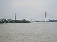 | |
|---|---|---|
| Indonesia | ||
| Malaysia | ||
| Philippines | ||
| Thailand | ||
| Vietnam | ||
Cable-stayed bridges by country | ||
| NCER Perlis |
|
|---|---|
| NCER Kedah | |
| NCER Penang |
|
| NCER Perak | |