Tennessee State Route 67
| ||||
|---|---|---|---|---|
| Route information | ||||
| Maintained by TDOT | ||||
| Length: | 63.88 mi (102.80 km) | |||
| Major junctions | ||||
| West end: |
| |||
|
| ||||
| East end: |
| |||
| Location | ||||
| Counties: | Washington, Carter, Johnson | |||
| Highway system | ||||
| ||||


State Route 67 is a state-maintained highway in northeastern Tennessee, including a four-lane divided highway segments in both Washington County and Carter County, and part of a significant two-lane segment passing over the Butler Bridge some 80 feet (24 m) above the TVA Watauga Reservoir (also referred locally to as Watauga Lake) near Butler in Johnson County, Tennessee.
Route description
Washington County
In 1988, a stretch of Tennessee State Route 67 was completed between Johnson City and Elizabethton as part of Quad-Cities Beltway projects.[1] The highway follows Cherokee Road through most of Johnson City before merging with U.S. Route 321 (University Parkway) near East Tennessee State University, and continuing eastward.
Carter County
SR 67 enters in Carter County just past the Milligan Highway Exit at the Johnson City/Elizabethton city limits on a freeway four-lane segment. Traveling from Johnson City, this mostly unlighted freeway segment of SR 67 gains some modest elevation before finally rolling over a significant slope and finally arriving at cautioned marked sloped curve just before the freeway segment ends at the traffic signalled SR 359/Milligan Highway exit (near both the Elizabethton Municipal Golf Course and the Elizabethton Fire Department #3 Substation on the right).
Elizabethton
At the SR 359/Milligan Highway exit, SR 67 continues on into Elizabethton as a four-lane down onto a mostly level and commercially developed segment (beginning at the junction SR 362 at Gap Creek Road) that is locally referred to as Elk Avenue. The City of Elizabethton itself mostly lies within two river valleys ringed by high mountains and significant hills.
SR 67/Elk Avenue parallels the Watauga River (to the left and north) before passing by a reconstructed interpretation of Fort Watauga at Sycamore Shoals State Park (the historical site of both the 1775 Transylvania Purchase and also the later staging area of the Overmountain Men, who crossed the mountains and defeated British Loyalists in South Carolina during the 1780 Battle of Kings Mountain) and the Sycamore Shoals Hospital (on the left), and moving more distantly away from the Watauga River. There are at least three busy local intersections with traffic signals found along this stretch of SR 67, including: Hudson Avenue (Walmart on the left), Bemberg Road (Elizabethton High School on the right), and Mill Street (Krystal's on the left), before arriving at the Y-forked intersection with traffic signals where SR-67 leaves the remainder of Elk Avenue through the Elizabethton downtown business district.
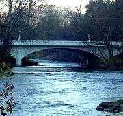
Broad Street Bridge.
SR 67 veers about 45 degrees in direction toward the left at the Elk Avenue Y-fork as commercially developed segment that is locally referred to as Broad Street, with SR 67 passing through usually busy local intersections at North Roan Street (McDonald's on the left; also running into the Old Bristol Highway) and Sycamore Street (Taco John's on the left) before reaching the Broad Street Bridge in Elizabethton.
SR 67/Broad Street first passes over the Doe River in Elizabethton on the c. 1926 concrete arch Broad Street bridge while continuing on as a four-lane highway, and then passes through the non-traffic signalled intersection of Main Street before turning south (right). SR 67 joines with U.S. Highway 19-E/SR 67, and the merged roads continue south across the Doe River at the East Side bridges within Elizabethton.
Further on south, the four-laned highway runs closely parallel with the Doe River. SR 67 starts gaining some gradual elevation and eventually crosses a series of bridges over the Doe River at the Valley Forge community just out side of the Elizabethton city limits (a left turn off SR 67 and onto Beck Moutanin Road after the first bridge is an alternative route to both the TVA Watauga Dam and the TVA Wilbur Dam).
SR 67 completes a final fourth and curving high double bridge crossing before arriving at Hampton.
Hampton
At the small, mountainous community of Hampton, the four-laned SR 67 and US 321 split off from the U.S. Highway 19-E concurrency and continue eastward. Here, the road begins as a two-lane segment, briefly passing by commercial areas in Hampton (including a U.S. post office, a Dollar General store and a non-attended public vehicle parking area for Appalachian Trail hikers arriving or entering the "AT" at Hampton), and then exiting Hampton over a high ridge.
Watauga Lake
Upon leaving Hampton, SR 67 again continually increases in elevation and roughly runs for several miles parallel to the shoreline of the massive Watauga Lake, through the Cherokee National Forest. Watauga Dam can be seen in the distance across the reservoir at the Rat Branch Boat Launch. At Fish Springs, SR-67 splits off from US 321, and veers northeastward, crossing Watauga Lake at the 80-foot (24 m) high Butler Bridge before entering Johnson County in Butler.
Johnson County
In Johnson County, the route continues northeastward up the Doe Creek Valley toward Mountain City. Along the way, passes through the unincorporated areas of Doeville, Pandora, Doe Valley, and Dewey. At Doeville, it junctions with SR-167, which continues southeastward up the Roan Creek Valley to emerge in the Shouns Crossroads area of southern Mountain City. In downtown Mountain City, SR 67 begins a concurrency with U.S. Route 421, and junctions with the former alignment of SR-91 before turning south again. It rejoins with SR-167 at Shouns Crossroads, and continues southward. At Trade, the route leaves US-421 and heads eastward up the Jenkins Creek Valley toward North Carolina. At the state line, the roadway becomes North Carolina Highway 88.
Junction list
| County | Location | mi | km | Destinations | Notes |
|---|---|---|---|---|---|
| Washington | Lamar | Western terminus of SR-67 | |||
| Johnson City | Southern end of US-321 concurrency; southern terminus of SR-381 | ||||
| I-26 exit 24. | |||||
| Milligan Highway / Legion Street – Milligan College | Interchange | ||||
| Carter | Elizabethton | Northern terminus of SR-359 | |||
| Begin SR-91 overlap | |||||
| Northern terminus of SR 362 | |||||
| Northern terminus of SR-400 | |||||
| Northern end of US-19E/US-321/SR-37/SR-91 overlap | |||||
| Hampton | Southern end of US-19E/SR-37 overlap | ||||
| | Southern end of US-321 concurrency; western terminus of SR-159 | ||||
| Johnson | Doeville | Western terminus of SR-167 | |||
| Mountain City | Northern end of US-421/TN-34 concurrency; Northern terminus of SR-418 | ||||
| Southern terminus of SR-418 | |||||
| Trade | Southern end of US-421/TN-34 concurrency | ||||
| | Eastern terminus of TN 67 at the North Carolina state line | ||||
1.000 mi = 1.609 km; 1.000 km = 0.621 mi
| |||||
References
- ↑ http://www.jcmpo.org/time1.html Johnson City MPO: Timeline of Key Transportation Events - Johnson City, Tennessee.
External links
| Wikimedia Commons has media related to Tennessee State Route 67. |