Monte Terminillo
| Monte Terminillo | |
|---|---|
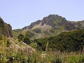 Terminillo seen from the east | |
| Highest point | |
| Elevation | 2,217 m (7,274 ft) |
| Coordinates | 42°29′N 13°00′E / 42.483°N 13.000°ECoordinates: 42°29′N 13°00′E / 42.483°N 13.000°E |
| Geography | |
 Monte Terminillo Italy | |
| Location | Lazio, Italy |
| Parent range | Apennines |
Monte Terminillo is a massif in the Monti Reatini, part of the Abruzzi Apennine range in central Italy. It is located some 20 km from Rieti and 100 km from Rome and has a highest altitude of 2,217 metres (7,274 ft).
It is a typical Apennine massif, both for its morphology, articulated but not exceedingly sharp, and for the fauna and vegetation. Its slopes are separated by the neighbouring smaller massifs by deep valleys, including the Valle Leonina, leading to Leonessa, and the Ravara and Capo Scura valleys leading to that of the Velino River. On the opposite sides are the Valle dell'Inferno ("Hell's Valley") and Valle degli Angeli ("Angels' Valley") leading to Rieti's plain and the mounts of Cantalice.
The Terminillo is an active ski resort.
See also
External links
![]() Media related to Monte Terminillo at Wikimedia Commons
Media related to Monte Terminillo at Wikimedia Commons
- monteterminillo.net (Italian)
- terminillo.it (Italian)