Schöllenen Gorge
Coordinates: 46°38′51″N 8°35′24″E / 46.64750°N 8.59000°E
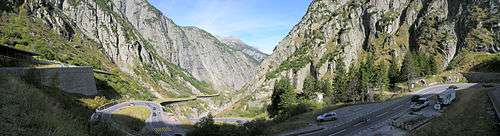
Schöllenen Gorge (German: Schöllenenschlucht, or pronouncing the region: Schöllenen) is a gorge formed by the upper Reuss in the Swiss canton of Uri between the towns of Göschenen to the north and Andermatt to the south. It provides access to the St Gotthard Pass.
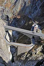
Enclosed by sheer granite walls, its road and railway require several spectacular bridges and tunnels, of which the most famous is a stone bridge known as the Teufelsbrücke (or Devil's Bridge).
Geology
The lower Urseren marks the boundary of the Aar massif with the autochthonous sediment of the Gotthard nappe ("Urseren-Zone"). In Altkirch quarry, on the southern end of the gorge, Triassic and Jurassic sediments are exposed. In the Schöllenen Gorge (at the Urnerloch tunnel), the Reuss enters the cristalline Aar massif (Aar granite), the gorge itself being an exemplary late alpine fluvial Water gap.[1]
History
Early history
The name of the gorge is from Rumantsch *scalinae ("stairs, steps"); recorded in German as Schellenden in 1420.[2] It formed the upper limit of Alemannic settlement in the Alps prior to the 12th century, and the border between the bishoprics of Constance and Raetia Curensis.
The gorge appears to have been passable by a difficult footpath by the mid-12th century. This path was forced to avoid the southern part of the gorge, taking a steep ascent from Brüggliwaldboden, climbing above 1,800 m before descending to Hospental via Bäzberg. The eponymous scalinae presumably referred to steps hewn into the rock to facilitate the ascent.[3]
The gorge was first opened up as a bridle path with the construction of a wooden bridge in the 1220s. This was of great strategic importance because it opened the Gotthard Pass, with historical consequences both regionally and to the Italian politics of the Holy Roman Empire.[4]
The original bridle path across Schöllenen was realised by means of a wooden ledger attached to the rock wall, known as Twärrenbrücke, and a wooden bridge across the gorge, recorded as stiebende Brugge ("spray bridge") in 1306. The Twärrenbrücke (from twer "across, athwart"[5]) rested on beams laid across the gorge. A tradition imagining it as supported by hanging chains developed only after its collapse in the 18th century.[6] The technology associated with the construction of the Twärrenbrücke is attributed to the Walser, who are known to have begun settlement in Urseren still in the 12th century.[7] 16th-century historiography attributes the construction of the bridge to one Heini (Heinrich), blacksmith in Göschenen. Robert Schedler published a historical novel surrounding the construction of the Schöllenen bridle path, Der Schmied von Göschenen, in 1919.
Devil's Bridge legend
In Early Modern Switzerland, a legend developed which attributed the construction of the bridge to the Devil. This is a motif attached to numerous old bridges in Europe (see Devil's Bridge for a comparative account). The name Teiffels Brucken ("Devil's Bridge", modern German: Teufelsbrücke) is first recorded in 1587.[8]
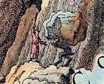
The legend itself is related by Johann Jakob Scheuchzer (1716). According to Scheuchzer, he was told a local legend according to which the people of Uri recruited the Devil for the difficult task of building the bridge. The Devil requested to receive the first thing to pass the bridge in exchange for his help. To trick the Devil, who expected to receive the soul of the first man to pass the bridge, the people of Uri sent across a dog by throwing a piece of bread, and the dog was promptly torn to pieces by the Devil. Enraged at having been tricked the Devil went to fetch a large rock to smash the bridge, but, carrying the rock back to the bridge, he came across a holy man who "scolded him" (der ihn bescholten) and forced him to drop the rock, which could still be seen on the path below Göschenen.[9] A modern retelling was published by Meinrad Lienert, Schweizer Sagen und Heldengeschichten (1915). According to Lienert's version, a goat was sent across the bridge instead of a dog, and instead of the holy man, the Devil, when he was taking a break exhausted from carrying the rock, came across an old woman who marked the rock with a cross, forcing the Devil to abandon it and flee.
The legend does not appear to have existed before the 16th century, and its origin in local tradition is uncertain. Lauf-Belart (1924) surmised that the name Teufelsbrücke was originally due to an erroneous interpretation by learned travellers, which only in the 17th century gave rise to the local legend involving the Devil.[10] However, similar legends exist for the Teufelsbrück in Hamburg, Germany, as well as for other German bridges (see Brickegickel).
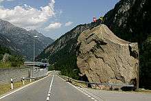
The Devil's Stone (Teufelsstein) is a large block of granite near Göschenen, with a height of c. 12 m and a mass of c. 220 tons. In 1887, it was sold to the Maestrani Schweizer Schokoladenfabrik for 80 francs. Painted yellow, it now served as an advertisement for chocolate. In 1923, there were plans to demolish it, but it was preserved on the initiative of Max Oechslin, president of Naturforschende Gesellschaft Uri. In 1970, the Devil's Stone was again scheduled for destruction, to make way for the N2 motorway. This time, there was a broad movement to preserve it, and in 1971, federal authorities agreed to move the stone, with projected costs of 250,000 francs (of which the canton of Uri was to contribute 7,000). This led to a popular campaign opposing the plan because the cost was seen as excessive. The liberal newspaper Gotthard-Post proposed to spend the money on the construction of a retirement home instead, collecting 1,000 signatures in support. The cantonal government now argued that there was no legal basis for the destruction of the stone because it had been the property of Naturforschende Gesellschaft Uri since 1925. On 1 September 1972, the Federal Council finally agreed to moving the stone, and it was moved 127 metres in an operation costing CHF 335,000.[11] It is now situated on the ramp of exit 40 (Göschenen) of the motorway, at the entrance of Gotthard Road Tunnel, visible both from the railway and from the motorway.
Early modern history
The wooden bridge Stiebender Steg was replaced by a stone bridge in 1595, which came to be known as Devil's Bridge (Teufelsbrücke).
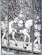
On St Patrick's Day (17 March) 1608 Hugh O'Neill, Earl of Tyrone was fleeing the English with 98 of his fellow-Gaels when, crossing the Devil's Bridge, one of the horses carrying his fortune plunged into the torrent below; the horse was recovered, but not the gold, which was lost in the raging torrent.
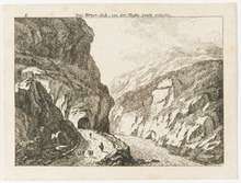
A new road, including a tunnel with a length c. 60 m,[12] replacing the Twärrenbrücke was built in 1707/8. The tunnel, known as Urnerloch, was the first road tunnel to be built in the Alps. It was constructed by Pietro Morettini (1660–1737). Following its construction, the Twärrenbrücke was no longer maintained and allowed to collapse.
H. R. Schinzin in 1783 mentions another bridge, marking the border between Uri and Urseren, known as Mittelbrücke or Tanzenbein.[13]
In 1799, it was the site of one of the most dramatic battles of Suvorov's Italian and Swiss expedition during the Napoleonic Wars. The bridge was heavily damaged by the retreating French army. As a result, the route's trade with Italy shifted to the Splügenpass. The Suvorov monument, just south of the Devil's Bridge, was commissioned by the Russian Empire in 1899.
Modern engineering

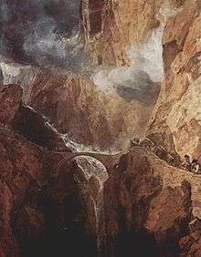
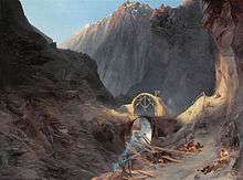
A replacement cut stone bridge was planned and executed by Karl Emanuel Müller (1804-1869), the cantonal engineer in charge of the stretch of the new Gotthard road between Göschenen and Hospental. Construction took 10 years, and was the subject of a famous painting by Karl Blechen in 1830-32. The new bridge allowed (single-lane) motorized traffic, opening the Gotthard Pass to automobiles. The 1595 bridge fell out of use after the completion of the second bridge in 1830, and it collapsed in 1888.
The Gotthard railway project of 1872 avoided the Schöllenen Gorge by building the Gotthard Rail Tunnel under it, but the Schöllenenbahn, a rack railway, was built through the gorge in 1917. The modern road bridge and tunnel date to 1958. It served as the main road across the Central Alps during the 1960s and 1970s, but since the construction of the Gotthard Road Tunnel in 1980 it has only been of regional importance, connecting Uri with canton of Valais and the Surselva.
References
| Wikimedia Commons has media related to Schöllenen. |
- ↑ Aaregranit in der Schöllenen und gotthardmassivische Sedimente, Géotope suisse n°302 (2012).
- ↑ the modern spelling in ö is a hypercorrection based on the phonology of the dialect of Uri, as in Göschenen < *cascina. It is unclear whether the -d- in the forms Schellenden, Geschenden is anaptyctic or if it represents a Rumantsch suffix complex *-ione-ata- (as it were *skal-ion-ata- > *skalinda > schellenden; RN 2,1033). A popular etymology connecting German schellen "to ring, resound" is reported by Brandstetter, 'Urseren', Vaterland 69 (1907). ortsnamen.ch
- ↑ "Die Wegbarmachung der Schöllenen musste spätestens in der ersten Hälfte des 12. Jahrhunderts stattgefunden haben. Der Weg, der schon vor der Erschliessung der Schöllenen begangen wurde, führte über den Bätzberg. Von Hospental, welcher Name aus dem römischen Hospitium-Herberge herkommt, führte der Weg über die Tännlenbrücke nach Tännlen, urkundlich ‹Tenlon› geheissen, und von da an der Lehne des Bätzberges entlang nach dem heutigen Fort Bätzberg. Beim Bau der dortigen Festungsanlagen stiess man auf ein gepflästertes Teilstück dieses Weges. Nun ging es leicht abwärts auf den sogenannten Brückwaldboden und von da erfolgte der steile Anstieg durch die Felsen in die mittlere Schöllenen. Um diesen Anstieg zu ermöglichen, war man gezwungen, Stufen in den Felsen zu hauen. Von diesen Stufen, lateinisch ‹scalinae›, leitet sich ohne Zweifel das Wort Schöllenen ab. Muheim, Strassenbau-Politik (1945), p. 24.
- ↑ The construction of the bridle path dates to "the first third of the 13th century", most likely to 1225/6, certainly by 1230. The chapel to St Gotthard on the pass was consecrated in 1230. In 1231, Henry VII granted imperial immediacy to Uri in order to remove this now-important strategic asset from Habsburg influence. The first contemporary account of a crossing of the pass dates to 1236 (Albert of Stade). By 1237, there was a hospice and substantial traffic.Egli, Emil, 'Der St. Gotthard : Bedeutung und Auswirkungen', Geographica Helvetica 46 (1991), 60–66.
- ↑ Alois Kocher, Der alte St. Gotthardweg: Verlauf, Umgehung, Unterhalt (1951), p. 84
- ↑ Helmut Stalder, Mythos Gotthard: was der Pass bedeutet, Orell Füssli (2003), p. 29. Noch zu Anfang dieses Sekulums hieng eine hölzerne Brücke in Ketten, auf welcher man um den Felsen herum kam" (Hans Rudolf Schinz, 1783).
- ↑ "Die Baumeister und -herren dieses Wegs sind unbekannt, jedoch ist eine Beteiligung der seit dem 12. Jh. in Ursern sesshaften Walser wahrscheinlich." (Stadler 2011)
- ↑ in 1574 recorded as quo loco pons est quem Satanae aut inferni pontem nominant Simler, Vallesiae Descriptio, p. 102. The 1587 reference is Ryff, Reissbiechlin: Do kompt man stracks unversechens zuo des Teiffels Brucken, al Ponto Dilfernno genant. Dz ist ein solliche Brucken, die hoch ob dem Wasser mit einem eintzigen Bogen oder Gwelb von einem Felsen in den anderen gebauwen ist. Und diewyl dann dis Ort (= Raum Teufelsbrücke) eng und rings herumb mit hochen glatten Felsen umbringet und die Wasser also rouschen und stieben, so haben die Landleut Infernno, die Hell, und die Brucken El Ponto Dilferno, die Hellbrucken oder des Teuffelsbrucken, genent..
- ↑ Johann Jakob Scheuchzer, Naturgeschichte des Schweitzerlandes vol. 2 (1747 [1716]), p. 94.
- ↑ "Ich bin überzeugt, dass der Name Teufelsbrücke ein literarischer Name ist, der von Gelehrten der Brücke gegeben worden und ins Volk gedrungen ist und der die allgemein verbreitete Sage vom Teufel als Baumeister nach sich gezogen und hier lokalisiert hat. Um die Wende vom 16. zum 17. Jahrhunder mag diese Wandlung vor sich gegangen sein. Denn noch 1595 heisst die Brücke in Urseren Stiebende, in der Literatur aber (vereinzelt ja schon Ende des 15. Jahrhunderts) Teufelsbrücke allgemein, bis durch die Historiker um die Wende zum 19. Jahrhundert der alte Name wieder ausgegraben wurde. Bis tief in die zweite Hälfte desselben blieb die richtige Ansicht vorherrschend, dass es zwei Namen für dasselbe Ding seien. Da wurde auf dem Umweg über Deutschland der Irrtum eines zürcherischen Reiseschriftstellers, der den Namen Stiebende Brücke auf einen etwas eigenartig gebauten, sonst aber ganz harmlosen Steg bezog, zum Dogma erhoben, also dass dieser Steg unversehens Weltberühmtheit erhielt." Lauf-Belart, Gotthardpass, 1924 p. 165f.
- ↑ Tyfelsbrigg, Freilichtspiele Andermatt (2013), p. 28
- ↑ the length of the Urnerloch is variously reported as 58 m, 61 m or 64 m.
- ↑ H. R. Schinz, Beiträge zur nähern Kenntniss des Schweizerlandes p. 29.
- Hans Stadler: Schöllenen in German, French and Italian in the online Historical Dictionary of Switzerland.
- R. Laur-Belart, Studien zur Eröffnungsgeschichte des Gotthardpasses (1924)
- R. Gisler-Pfrunder, Die Teufelsbrücke am St. Gotthard (2005)