Texas State Highway 23
| ||||||||||
|---|---|---|---|---|---|---|---|---|---|---|
 | ||||||||||
| Route information | ||||||||||
| Maintained by TxDOT | ||||||||||
| Length: | 28.704 mi[1] (46.195 km) | |||||||||
| Existed: | 1990 (signed in 1959)[1] – present | |||||||||
| Major junctions | ||||||||||
| South end: |
| |||||||||
|
| ||||||||||
| North end: |
| |||||||||
| Location | ||||||||||
| Counties: | Lipscomb | |||||||||
| Highway system | ||||||||||
| ||||||||||

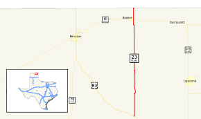
State Highway 23 or SH 23 is a state highway in the U.S. state of Texas maintained by the Texas Department of Transportation (TxDOT). The highway, located in eastern Lipscomb County in the Texas Panhandle, begins at US 83 northwest of Canadian and extends northward through the town of Booker to the Oklahoma state line. The highway's route designation is numerically continuous with subsequent routes in Oklahoma and Kansas and, together with Oklahoma State Highway 23 and Kansas Highway 23, forms part of a single route from US 83 in Texas to US-83 near Selden, Kansas.
The route number was one of the original highways proposed by the state highway department in 1917, and was used over various shifting alignments in central and north central Texas in the 1920s and 1930s. The current highway was originally built as part of Texas' system of Farm to Market Roads in 1949. The state began signing the route as SH 23 in 1959, although the highway officially retained its Farm to Market designation until 1990. SH 23 intersects one other state highway, SH 15, at Booker.
History
Former routes

SH 23 was one of the original 26 state highways proposed in 1917, with a route from Brady to Olney.[2] The route was relocated westward from Junction to Seymour between 1922[3] and 1926.[4] By 1928, the route was extended northward to Vernon.[5] The route was shortened with its southern terminus moved northward to Ballinger by 1931. The route followed US 67 between Ballinger and Coleman, and US 283 from Rising Star to its new northern terminus where US 283 crossed the Red River toward Altus, Oklahoma.[6] By 1935, the route was redirected further south along US 283 to Brownwood and then back to Brady, replacing Texas State Highway 129 from Rising Star to Brownwood.[7] By 1939, the route had been decommissioned,[1] being absorbed by the current US 377, US 183, SH 6, and US 283.

SH 23A was an alternate route of SH 23 between Albany and Cross Plains created between 1919[8] and 1922.[3] The alternate route was the eastern path through Cisco while the main route was the western path through Baird. By 1926, the eastern route had been reassigned as the main route of SH 23 while the western route became the alternate.[4] The alternate route was removed by 1928.[5]
Current route

The current route was originally designated Farm to Market Road 1265 in 1949. That road began as a 5.7-mile (9.2 km) route extending southward from the state line through Booker.[9] That route, along with what was then SH 117 passing through Booker connected two discontinuous portions of OK 15.[10] FM 377 was extended to FM 1265 connecting the road to Perryton in 1954,[11] while FM 1265 was extended an additional 12.0 miles (19.3 km) southward.[9] The connecting route SH 117 at Booker was renamed SH 15 in 1955 matching the numbering of its adjoining Oklahoma route.[12][13] FM 1265 was completed in 1956 when it was extended the remaining distance to US 83.[9]
In 1959, the portion of OK 15 between Texas and Kansas was renamed OK 23 conforming with the connecting Kansas highway.[14] That same year, TxDOT began signing FM 1265 as SH 23, although the road officially retained the FM 1265 designation.[1] RM 3260 was branched off in 1972 and completed in 1978 connecting the highway to Lipscomb.[15] In 1990, the highway was officially designated SH 23,[1] and FM 1265 was decommissioned.[9]
Route description
SH 23 begins at its southern terminus at US 83 in southwestern Lipscomb County northwest of Canadian. The 28.7-mile (46.2 km)[1] highway intersects RM 3260 branching off to the east toward Lipscomb, and then in the northeastern portion of the county FM 377 branches off to the west toward Perryton. In Booker, the only town along the highway, SH 23 intersects SH 15. The highway then proceeds to the north crossing the Oklahoma state line into Beaver County, Oklahoma south of Elmwood, Oklahoma. The highway becomes OK 23 at the state line.[16]
The highway encounters mostly modest hills for most of its route allowing the highway to generally follow long, straight stretches before emerging onto a flat plain south of Booker to the state line.[17]
Major intersections
The entire route is in Lipscomb County.
| Location | mi[18] | km | Destinations | Notes | |
|---|---|---|---|---|---|
| | 0 | 0.0 | Southern terminus | ||
| | 8.0 | 12.9 | |||
| | 21.1 | 34.0 | |||
| Booker | 25.6 | 41.2 | |||
| | 28.7 | 46.2 | Northern terminus; roadway continues into Beaver County, Oklahoma as OK 23 | ||
| 1.000 mi = 1.609 km; 1.000 km = 0.621 mi | |||||
References
- 1 2 3 4 5 6 Transportation Planning and Programming Division (n.d.). "State Highway No. 23". Highway Designation Files. Texas Department of Transportation. Retrieved 2010-11-28.
- ↑ Map Showing Proposed System of State Highways (Map) (June 1917 ed.). ¾"=25 mi. Cartography by John D. Miller. Texas State Highway Department, Office of State Highway Engineer. July 1917. Retrieved 2010-11-28.
- 1 2 Highway Map of the State of Texas (Map) (Dec. 1, 1922 ed.). 1"=20 mi. Texas State Highway Department. Retrieved 2010-11-28.
- 1 2 Official Highway Map of Texas (Map) (1926 ed.). 1"=30 mi. Texas State Highway Commission. Retrieved 2010-11-28.
- 1 2 Official Highway Map of Texas (Map) (1928 ed.). 1 ⅛"=20 mi. Texas State Highway Commission. Revised to 3-1-1929. Retrieved 2010-11-28. Check date values in:
|date=(help) - ↑ Official Map of the Highway System of Texas (Map) (June 15, 1933 ed.). ⅞"=30 mi. Cartography by R. M. Stene. Texas State Highway Commission. § E16-K17. Retrieved 2010-11-28.
- ↑ Official Map of the Highway System of Texas (Map). 1"=29 mi. Cartography by R. M. Stene. Texas State Highway Commission. Retrieved 2015-06-09.
- ↑ Highway Map, State of Texas (Map) (Oct. 1, 1919 ed.). 1"=25 mi. Texas State Highway Department. Retrieved 2010-11-28.
- 1 2 3 4 Transportation Planning and Programming Division (n.d.). "Farm to Market Road No. 1265". Highway Designation Files. Texas Department of Transportation. Retrieved 2010-11-28.
- ↑ Map of Oklahoma's State Highway System (PDF) (Map) (1950 ed.). Oklahoma Department of Highways. Retrieved 2010-11-28.
- ↑ Transportation Planning and Programming Division (n.d.). "Farm to Market Road No. 377". Highway Designation Files. Texas Department of Transportation. Retrieved 2010-11-28.
- ↑ Transportation Planning and Programming Division (n.d.). "State Highway No. 117". Highway Designation Files. Texas Department of Transportation. Retrieved 2010-11-28.
- ↑ Transportation Planning and Programming Division (n.d.). "State Highway No. 15". Highway Designation Files. Texas Department of Transportation. Retrieved 2010-11-28.
- ↑ 1959 Oklahoma Road Map (PDF) (Map) (1959 ed.). Oklahoma Department of Highways. Retrieved 2010-11-28.
- ↑ Transportation Planning and Programming Division (n.d.). "Ranch to Market Road No. 3260". Highway Designation Files. Texas Department of Transportation. Retrieved 2010-11-28.
- ↑ County Grid Map (PDF) (Map) (2010 ed.). 1:120,000. Texas Department of Transportation. p. 261, 262, 263. Retrieved 2010-11-28.
- ↑ Perryton, Texas-Oklahoma (PDF) (Map) (1986 ed.). 1:100,000. 30x60 minute series (topographic). United States Geological Survey. Retrieved 2010-11-28.
- ↑ Google (2010-11-28). "Route of SH 23" (Map). Google Maps. Google. Retrieved 2010-11-28.