Texas State Highway 258
| ||||
|---|---|---|---|---|
 | ||||
| Route information | ||||
| Maintained by TxDOT | ||||
| Length: | 11.165 mi[1] (17.968 km) | |||
| Existed: | by 1938 – present | |||
| Major junctions | ||||
| West end: |
| |||
| East end: |
| |||
| Location | ||||
| Counties: | Wichita | |||
| Highway system | ||||
| ||||

State Highway 258 (SH 258) is a short state highway in northern Texas.[1]
Route description
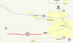
SH 258 begins at SH 25 in the rural community of Kadane Corner.[2] The highway runs eastward, just north of the Archer County line. The route ends at a junction with US 82 / US 277 southwest of Wichita Falls.[1]
History
SH 258 route was designated by 1938 along its current route.[1]
Major intersections
The entire route is in Wichita County.
| Location | mi[3] | km | Destinations | Notes | |
|---|---|---|---|---|---|
| Kadane Corner | 0.0 | 0.0 | Western terminus | ||
| Kamay | 1.7 | 2.7 | |||
| | 4.4 | 7.1 | |||
| | 7.7 | 12.4 | |||
| | 11.2 | 18.0 | Eastern terminus | ||
| 1.000 mi = 1.609 km; 1.000 km = 0.621 mi | |||||
References
- 1 2 3 4 Transportation Planning and Programming Division (n.d.). "State Highway No. 258". Highway Designation Files. Texas Department of Transportation. Retrieved 2008-04-04.
- ↑ Transportation Planning and Programming Division (2012). Texas County Map Book (PDF) (Map) (2012 ed.). 1:120,000. Texas Department of Transportation. p. 358. OCLC 867856197. Retrieved 2011-09-29.
- ↑ Google (2011-09-29). "Overview map of Texas State Highway 258 Distances Between Interchanges" (Map). Google Maps. Google. Retrieved 2011-09-29.
This article is issued from Wikipedia - version of the 11/12/2016. The text is available under the Creative Commons Attribution/Share Alike but additional terms may apply for the media files.