Texas State Highway 302
| ||||
|---|---|---|---|---|
 | ||||
| Route information | ||||
| Maintained by TxDOT | ||||
| Length: | 83.17 mi[1] (133.85 km) | |||
| Existed: | 1938 – present | |||
| Major junctions | ||||
| West end: |
| |||
|
| ||||
| East end: |
| |||
| Location | ||||
| Counties: | Reeves, Loving, Winkler, Ector | |||
| Highway system | ||||
| ||||

State Highway 302 or SH 302 is a Texas state highway maintained by the Texas Department of Transportation (TxDOT). The 83.2-mile (133.9 km) route runs from U.S. Route 285 northwest of Pecos to Interstate 20 near Odessa. The route passes through Reeves, Loving, Winkler, and Ector counties. SH 302 has intersections with SH 115 and SH 18 in the Kermit area, and SH 158 east of Notrees. The route intersects Loop 338 and Spur 450 in West Odessa and then follows Loop 338 along the west side of Odessa until SH 302 terminates at I-20. SH 302 also intersects several Farm to Market Roads and an Interstate business route.
SH 302 was originally designated in 1938 as a route between Kermit and Odessa, but has since incorporated the former SH 276 and a defunct Farm to Market Road to achieve its present length. Loving County, where the route passes through Mentone, is the nation's least populous county in stark contrast to the urbanized eastern end of the route in the Odessa area.
History

SH 302 was originally created between Kermit and Odessa in 1938, but with the route's designation being contingent upon completion of work then being done in Winkler County. Soon after, the state assumed maintenance of the Ector County portion, and the following year in 1940 the state assumed maintenance of the Winkler County part of the route.[1] Also in 938, SH 276 was designated over the current western terminus at US 285 to Mentone,[2] although a portion of that route existed as early as 1936 as an earth road from US 285 to the former town of Arno.[3]

In 1946, SH 276 was designated over a second, discontinuous portion of the present route between SH 115 west of Kermit to SH 82 in Kermit.[2] Later that year, that designation was dropped and that segment was added as an extension of SH 302 westward to SH 115.[1][2] In 1949, Farm to Market Road 1211 was designated over a 2.0-mile (3.2 km) section of the present route from Mentone to the northeast. In 1952, FM 1211 was extended incrementally to the Winkler County line and then to SH 115.[4] The following year the designation of SH 276 was dropped and that road between US 285 and Mentone was assigned as a discontinuous segment of SH 302.[1][2] In 1958 SH 82, the intersecting route Kermit, was renamed SH 18.[5][6]
In 1967, SH 302 was rerouted over Loop 338 in Ector County to I-20.[1] Its former route between Loop 338 and US 385 in Odessa was then designated as Spur 450.[1][7] The discontinuous nature of SH 302 remained until 1990 when FM 1211 between Mentone and SH 115 near Kermit was canceled and combined with SH 302 unifying the current route.[1][4]
Route description
SH 302 begins at US 285 between Pecos and Orla in Reeves County as a two-lane road. The route proceeds to the northeast crossing the Pecos River before passing through Mentone in Loving County. The route continues eastward crossing into Winkler County and intersecting SH 115 just outside Kermit. In Kermit, the route is known as Jim Sharp Blvd. and widens to four lanes with a left turn lane in the middle. After crossing SH 18, the route continues eastward losing the left turn lane as it leaves town. The route continues as a four-lane, undivided highway into Ector County where the route is known as Kermit Hwy. Just east of Notrees, the route becomes a divided highway and passes along the northern edge of West Odessa before joining along Loop 338, Odessa's beltway. The passage of SH 302 along Loop 338 begins as a freeway, but later has limited crossings at grade. SH 302 terminates at the intersection of Loop 338 and I-20.[8]
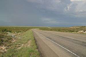
The route passes through largely level terrain requiring only gentle grades. The route traverses many oil fields along its length, and encounters fields of sand dunes east of Kermit.[9][10] The western portion of the highway west of Kermit is especially isolated as the route passes through Loving County, the only county in the nation with fewer than 100 residents.[11]
Major intersections
| County | Location | mi[8] | km | Destinations | Notes |
|---|---|---|---|---|---|
| Reeves | | 0 | 0.0 | Western terminus | |
| Loving | | 3.6 | 5.8 | ||
| Mentone | 5.4 | 8.7 | |||
| 5.4 | 8.7 | ||||
| Winkler | | 30.3 | 48.8 | ||
| | 33.5 | 53.9 | |||
| | 35.4 | 57.0 | West end of SH 115 overlap | ||
| | 35.5 | 57.1 | East end of SH 115 overlap | ||
| Kermit | 37.5 | 60.4 | |||
| Ector | | 59.0 | 95.0 | ||
| | 63.0 | 101.4 | |||
| West Odessa | 68.5 | 110.2 | |||
| 76.2 | 122.6 | ||||
| 78.4 | 126.2 | West end of Loop 338 overlap | |||
| Odessa | 79.5 | 127.9 | |||
| 80.5 | 129.6 | ||||
| | 82.2 | 132.3 | |||
| | 83.2 | 133.9 | East end of Loop 338 overlap; Eastern terminus | ||
1.000 mi = 1.609 km; 1.000 km = 0.621 mi
| |||||
See also
 U.S. Roads portal
 Texas portal
References
- 1 2 3 4 5 6 7 Transportation Planning and Programming Division (n.d.). "State Highway No. 302". Highway Designation Files. Texas Department of Transportation. Retrieved 2010-07-30.
- 1 2 3 4 Transportation Planning and Programming Division (n.d.). "State Highway No. 276". Highway Designation Files. Texas Department of Transportation. Retrieved July 30, 2010.
- ↑ Official Map of the Highway System of Texas (Map) (Centennial ed.). 1"=29 mi. Cartography by R. M. Stene. Texas State Highway Commission. Corrected to March 1, 1936. Retrieved July 30, 2010. Check date values in:
|date=(help) - 1 2 Transportation Planning and Programming Division (n.d.). "Farm to Market Road No. 1211". Highway Designation Files. Texas Department of Transportation. Retrieved July 30, 2010.
- ↑ Transportation Planning and Programming Division (n.d.). "State Highway No. 82". Highway Designation Files. Texas Department of Transportation. Retrieved July 30, 2010.
- ↑ Transportation Planning and Programming Division (n.d.). "State Highway No. 18". Highway Designation Files. Texas Department of Transportation. Retrieved July 30, 2010.
- ↑ Transportation Planning and Programming Division (n.d.). "State Highway Spur No. 450". Highway Designation Files. Texas Department of Transportation. Retrieved July 30, 2010.
- 1 2 Google (July 29, 2010). "Route of SH 302" (Map). Google Maps. Google. Retrieved July 29, 2010.
- ↑ Kermit, Texas (Map). 1:100,000. 30x60 minute series (topographic). United States Geological Survey. 1986. Retrieved July 31, 2010.
- ↑ Odessa, Texas (Map). 1:100,000. 30x60 minute series (topographic). United States Geological Survey. 1986. Retrieved July 31, 2010.
- ↑ "Table 2: Counties Ranked by Population: 2000" (PDF), Ranking Tables for Counties: Population in 2000 and Population Change from 1990 to 2000 (PHC-T-4), United States Census Bureau, p. 57, April 2, 2001 External link in
|work=(help)
External links
![]() Geographic data related to Texas State Highway 302 at OpenStreetMap
Geographic data related to Texas State Highway 302 at OpenStreetMap