Texas State Highway 351
| ||||
|---|---|---|---|---|
 | ||||
| Route information | ||||
| Maintained by TxDOT | ||||
| Length: | 25.122 mi[1] (40.430 km) | |||
| Existed: | 1943 – present | |||
| Major junctions | ||||
| West end: |
| |||
|
| ||||
| East end: |
| |||
| Highway system | ||||
| ||||

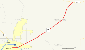
State Highway 351 (SH 351) is a 25.122-mile-long (40.430 km) Texas state highway that travels from Abilene northeast to an intersection with U.S. Route 180 (US 180) west of Albany. The highway was designated in 1943 as a replacement for US 80 Alternate.
Route description
SH 351 begins at an intersection with US 83 Business (Treadaway Boulevard) in Abilene. The highway heads east through Abilene along Ambler Avenue. It curves to the northeast prior to a diamond interchange with Interstate 20 (I-20). The highway heads northeast as it leaves the Abilene city limits on its way to intersections with FM 1082, FM 604, and FM 3522. It continues to the northeast to its eastern terminus at a concurrency of US 180 and SH 6.[2]
History
Junction list
| County | Location | mi | km | Destinations | Notes | |||
|---|---|---|---|---|---|---|---|---|
| Taylor | Abilene | Western terminus | ||||||
| I-20 exit 288 | ||||||||
| | ||||||||
| Callahan |
No major junctions | |||||||
| Jones |
No major junctions | |||||||
| Shackelford | | |||||||
| | Eastern terminus | |||||||
| 1.000 mi = 1.609 km; 1.000 km = 0.621 mi | ||||||||
See also
-
 U.S. Roads portal
 -
 Texas portal
References
- ↑ Transportation Planning and Programming Division (n.d.). "State Highway No. 351". Highway Designation Files. Texas Department of Transportation. Retrieved 2008-03-13.
- ↑ Google (2008-03-13). "overview map of SH 351" (Map). Google Maps. Google. Retrieved 2008-03-13.
This article is issued from Wikipedia - version of the 11/22/2016. The text is available under the Creative Commons Attribution/Share Alike but additional terms may apply for the media files.