Thattekere
| Thattekere ತಟ್ಟೆಕೆರೆ | |
|---|---|
| village | |
 | |
| Coordinates: 12°40′20″N 77°34′24″E / 12.67209°N 77.57345°ECoordinates: 12°40′20″N 77°34′24″E / 12.67209°N 77.57345°E | |
| Country |
|
| State | Karnataka |
| Taluks | Kanakapura |
| Languages | |
| • Official | Kannada |
| Time zone | IST (UTC+5:30) |
| Nearest city | Bangalore |
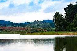
Thattekere is a village in Kanakapura taluk in Ramanagara district, 40km away from Bangalore. It has a population of 1293 in 2011.[1] The village derives its name from a lake there which is a picnic spot, "thatte" means plate and "kere" means lake in native Kannada language.
A Mahadeshwara temple is there in the village on west side of the Thattekere lake, situated in elephant corridor of Bannerghatta National Park and it is a birdwatching place.[2] Another tourist attraction Muthyalamaduvu is nearby.
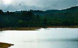
Forest in the background
References
This article is issued from Wikipedia - version of the 10/31/2016. The text is available under the Creative Commons Attribution/Share Alike but additional terms may apply for the media files.