Tiradentes, Minas Gerais
| Tiradentes | ||
|---|---|---|
| Municipality | ||
|
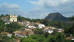
Downtown Tiradentes | ||
| ||
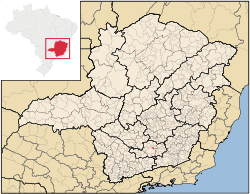 Location in the State of Minas Gerais | ||
| Coordinates: 21°06′31″S 44°10′28″W / 21.10861°S 44.17444°WCoordinates: 21°06′31″S 44°10′28″W / 21.10861°S 44.17444°W | ||
| Country |
| |
| Region | Southeast | |
| State |
| |
| Time zone | BST (UTC-3) | |
| • Summer (DST) | BDT (UTC-2) | |
| Postal Code | 36325-000 | |
Tiradentes is a municipality in the Brazilian state of Minas Gerais. It is located at 21°06′37″S 44°12′41″W / 21.11028°S 44.21139°W, has an area of 83.5 km², and a maximum height of 927 m. Tiradentes had an estimated population of 6,364, as of 2004. The original village was established in 1702 and became a city on 19 January 1718. It was named after "Tiradentes", a national hero, who was born there. The former name of the city was São José del Rey and it was changed as soon as Brazil adopted the Republic instead of the Monarchy.
It has been acclaimed as an unspoiled example of colonial architecture.
See also
- A section of the Estrada de Ferro Oeste de Minas narrow gauge railway from São João del Rei to Tiradentes has been preserved as a tourist line.
External links
| Wikimedia Commons has media related to Tiradentes (Minas Gerais). |
| Wikivoyage has a travel guide for Tiradentes. |
This article is issued from Wikipedia - version of the 10/10/2016. The text is available under the Creative Commons Attribution/Share Alike but additional terms may apply for the media files.