Topoľovka
| Topoľovka | |
| Village | |
.jpg) Main street in Topoľovka, the centre of village. Buildings on the left are the commune council building with civil registry and rural market | |
| Country | Slovakia |
|---|---|
| Region | Prešov Region |
| District | Humenné District |
| Elevation | 157 m (515 ft) |
| Coordinates | 48°55′10″N 21°48′30″E / 48.91944°N 21.80833°ECoordinates: 48°55′10″N 21°48′30″E / 48.91944°N 21.80833°E |
| Area | 7.787 km2 (3 sq mi) |
| Population | 824 (31 December 2005) |
| Density | 106/km2 (275/sq mi) |
| First mentioned | 1479 |
| Timezone | CET (UTC+1) |
| - summer (DST) | CEST (UTC+2) |
| Postal code | 066 45 |
| Phone prefix | 421-57 |
| Car plate | HE |
  Location of Topoľovka in Slovakia | |
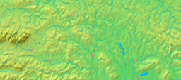  Location of Topoľovka in the Prešov Region | |
| Wikimedia Commons: Topoľovka | |
| Statistics: MOŠ/MIS | |
| Website: http://www.topolovka.sk | |
Topoľovka is a village and municipality in Humenné District in the Prešov Region of north-east Slovakia.
History
In historical records the village was first mentioned in 1479.
Geography
The municipality lies at an altitude of 157 metres (515 feet) and covers an area of 7.777 square kilometres (3.003 square miles). It has a population of about 825 people.
International relations
Twin towns — Sister cities
Topoľovka is twinned with:
External links
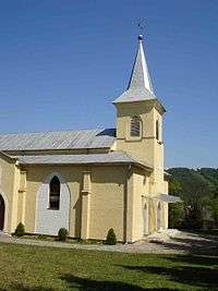
A Roman Catholic church in the village
This article is issued from Wikipedia - version of the 3/5/2016. The text is available under the Creative Commons Attribution/Share Alike but additional terms may apply for the media files.