Toronto Harbour
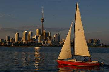
Toronto Harbour or Toronto Bay is a bay on the north shore of Lake Ontario, in Toronto, Ontario, Canada. It is a natural harbour, protected from Lake Ontario waves by the Toronto Islands. Today, the harbour is used primarily for recreational boating, including personal vessels and pleasure boats providing scenic or party cruises. Ferries travel from docks on the mainland to the Islands, and cargo ships deliver aggregates and raw sugar to industries located in the harbour. Historically, the harbour has been used for military vessels, passenger traffic and cargo traffic. Waterfront uses include residential, recreational, cultural, commercial and industrial sites.
Description
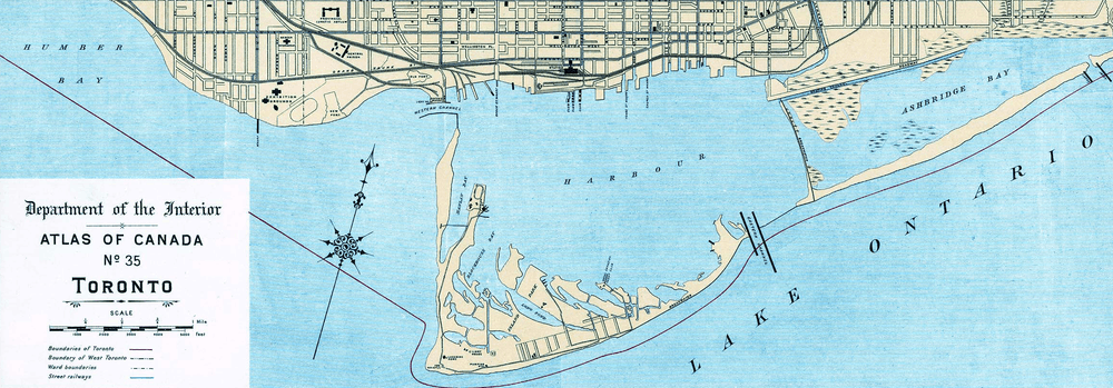
There are two harbours: the original natural harbour, today named the "Inner Harbour", and the "Outer Harbour". Access into the Inner Harbour is made via either the Western Gap or Eastern Gap. The Don River drains into the Inner Harbour from the north-east, through the Keating Channel.
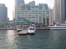
The Inner Harbour is used by pleasure boats and commercial vessels. The Ports Toronto agency maintains the harbour and operates port facilities and a passenger ship dock on the eastern shore. The north shore has a mixed range of uses including Harbourfront, a conversion from industrial land to recreational and cultural uses. Harbourfront has parks, hotels, an amphitheatre, and many other facilities. The north shore retains one port-related industrial use, the Redpath Sugar Refinery, while most of the lands have been converted to other uses. The Jack Layton Ferry Terminal is located at the foot of Bay Street and pleasure and party cruise boats dock along the shore to the west of York Street. The Toronto Islands are mostly parkland, and are the site of several boat clubs, an amusement park, an airport, and a small residential area.
The Western Gap is a 120 metres (390 ft) wide channel allowing western access to the Inner Harbour. The gap is deep enough (over 31 metres) to allow large ships (like lake freighters) to enter and exit into the Inner Harbour.[1] The Billy Bishop Toronto City Airport is located on the south side of the channel and is accessed by ferry and tunnel. Before the island airport was built, the waterway was wide with a shallow sandy shoal surrounding what became Hanlan's Point. The channel was dredged and the sands deposited to form the airport lands.
The Eastern Gap is an approximately 200 metres (660 ft) wide passage between Ward's Island and the western edge of the Port Lands and used by most freighters to enter into the inner harbour and port facilities. The gap was first formed from 1852 to 1858 when storms caused a break in the sandy spit that connected the area with mainland. Prior to the 1800s, small boat users had to use a portage on the western end of the sandy spit peninsula (thus requiring them to travel a short distance on land) from Lake Ontario to the inner harbour. After 1858, the Harbour Trust made the temporary channel into a permanent waterway.
Toronto also has a second harbour, called the Outer Harbour (Toronto Harbour is sometimes called the Inner Harbour). It was developed in the 1950s and 1960s by the Toronto Harbour Commission through the construction of a new breakwater called the Outer Harbour East Headland. At that time, it was expected that there would be a great upswing in the number of ships calling at Toronto once the Saint Lawrence Seaway opened. However, the need for an extra harbour never materialized, and private boats are the only traffic usually found there now. Ports Toronto operates a marina in the Outer Harbour and the municipal Cherry Beach park is also located in the Outer Harbour.
Port
Today, port facilities are limited to the eastern shore of the harbour, with the exception of the Redpath Sugar Refinery at the foot of Jarvis Street. The tonnage of cargo passing through the port is made up mostly of sugar to Redpath and aggregate materials (cement, stone), salt delivered to facilities on the eastern shore of the harbour.
- In 2007, the port handled 1.6 million tonnes of traffic, a 0.3% share of national port traffic, 16th out of 19 Canada Port Authority ports by traffic.[2]
- In 2006, Transport Canada ranked Toronto 39th out of 313 ports in all of Canada in total tonnage shipped.[3]
- Statistics Canada ranks the port 15th in shipping activity in Ontario.[4]
Geology
The makeup of the soil between the mainland and the island varies:
- Stone near the Western Gap
- Mud near the north shore, mouth of the Don River
- Sand near the airport and western parts of the island's north shore
- Clay near the centre of the harbour
Gaasyendietha
Gaasyendietha is Toronto's legendary Loch Ness Monster and it is sometimes spotted in Lake Ontario and even within the Toronto Harbour. The story of Gaasyendietha is a Native Canadian myth from the Seneca tribe.
History
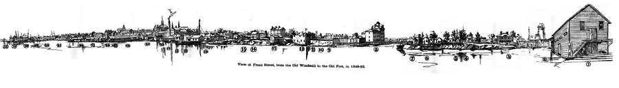
The original shoreline of the northern shore were low sandy bluffs, just south of today's Front Street. The mouth of the harbour pointed west. Fort York, on the north shore of the bay, near the mouth of Garrison Creek, guarded the harbour's mouth. It was briefly captured by American forces during the War of 1812.
The islands used to be a low sandy peninsula forming the southern limit of the bay. The Scarborough Bluffs are much larger bluffs that lie approximately ten kilometres east of the harbour. Strong lake currents over time washed the sand eroded from the bluffs westwards to form the peninsula surrounding the bay.
The peninsula became the Toronto Islands through the result of two storms and man-made activity. In 1852, a storm created a channel through the eastern edge of the peninsula that formed the south edge of the bay. The storm washed through excavations made for sand for local construction. In 1858, another storm widened the channel and made it permanent.[5]
The eastern shore of the bay, approximately six kilometres east, was a marsh around the mouth of the Don River. In addition to the Don River a number of smaller creeks flowed into the bay. The original site of the town of York had half a dozen short creeks that flowed through it. As the town developed they all became polluted, and were buried. As the city grew the larger creeks, including Russell Creek, Taddle Creek and Garrison Creek, were also filled in.
Development
.jpg)
The town of York was established in 1793 in a ten-block rectangle bounded by the present Front Street, Berkeley, Duke(now Adelaide) and George Street alongside Taddle Creek. A government wharf was built to handle the transfer of ships' cargoes. A garrison at the entrance to the harbour, at the mouth of Garrison Creek, was established to guard the harbour along with a blockhouse on the island. In 1801, York became an official port-of-entry for immigrants and cargo. In 1808, the Gibraltar Point lighthouse was built on the island to guide ships.[6]
In the early 19th century, cargoes destined for York would be transferred at Montreal to smaller boats such as Durham boats and batteaux to traverse the rapids of the St. Lawrence River. In 1825, the Lachine Canal was built to bypass the Lachine Rapids. Some of the boats used for cargo were now being built at Toronto Bay. Although not fully established by the War of 1812, the British colonial army was determined to set up boat-building for defense at York. An armed schooner was under construction, when the Americans attacked and the British burned the hull rather than surrender it. The invaders looted the town and destroyed military facilities.[7]
By the time of the establishment of the Town of Toronto, three large wharves existed for shipping, King's Wharf at Peter Street, Cooper's Wharf at Church Street and Merchant's Wharf at Caroline Street (today's Sherbourne Street). The new Queen's Wharf, at the foot of Bathurst Street was constructed in two stages, eventually reaching 244 feet (74 m) in length. Commissioned by the Province of Upper Canada, it cost £4,500. The first harbourmaster of Toronto, Hugh Richardson, was named in 1833. Richardson held the position until 1870.[8] While the Queen's Wharf no longer exists, the Queen's Wharf Lighthouse still exists, eventually moved to a location off today's Lake Shore Boulevard in 1929.[9] In 1849, the Harbour Trust was formed to manage the port and the Queen's Wharf.[10]
In 1832, the Gooderham and Worts Distillery went into operation, using a windmill on the waterfront, near the Don River, to provide power. The Distillery had been conceived as a plant to make flour, but the distillery business was much more popular. By 1837, the mill was producing more than 28,000 US gallons (110,000 L) of whiskey annually.[11]
By 1840, the waterfront was completely taken over by government and merchant wharves. The Esplanade, a 100 feet (30 m)-wide road, was proposed, just south of Front Street, with new water lots made from cribbing and filling of the shore to the south. The waterfront was extended to a survey line from the point of the Gooderham windmill west to a point due east of the old Fort Rouille.[11] Ostensibly for carriages and carts, the roadway eventually became primarily the route for rail lines in the central core. In exchange for 40 feet (12 m) of the Esplanade, the railways underwrote the infilling of the harbour. The Esplanade and infill project was complete by 1865.[12] A section of The Esplanade from Yonge Street to Berkeley Street still exists as a roadway. The rail lines moved to a viaduct in the 20th century.
The first rail line to the harbour was the Ontario, Simcoe and Huron Railroad in 1853. The next rail line was the Grand Trunk, which underwrote the Esplanade project in exchange for an easement to enter the City. The Canadian Pacific Railway arrived in 1886, through the purchase of the Credit Valley Railway.[13] Most of the area along the shoreline was connected to the railways. Manufacturers of products such as soap received raw materials via boat, produced the product at their location on the harbour, and distributed it via rail.
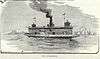
As well as cargo, the harbour also became a major passenger waypoint. By the 1880s, the harbour was handling 1,250,000 passengers annually through passenger steamship docks at the foot of Yonge Street. Passenger boats operated on Lake Ontario and the St. Lawrence River. Excursions to Niagara also departed from the Yonge Street docks.[5]
The western channel's depth was found to be too shallow by 1906 when the steam barge Resolute sank outside the harbour during a storm. The barge was unable to shelter in the harbour. The Queen's Wharf area was rebuilt during the years of 1908 to 1911 by the federal government. A new western channel was dug 1,300 feet (400 m) to the south of the existing one. The existing channel could not be dredged to a lower depth as it was solid rock.[14] The Queen's Wharf site became the eventual site of the Loblaws warehouse at the intersection of Bathurst Street and Fleet Street.
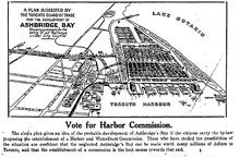
The 1910 Toronto Board of Trade proposal for the Ashbridge's Bay was for an industrial district for industrial offices and sites served by railway lines, public warehouses alongside docking facilities south of Keating Channel to the Eastern Gap and parkland/recreational strip at the south end.[15]
In 1911, the Toronto Harbour Commission was created. The lands of the waterfront that were owned by the City of Toronto were transferred to the Commission to administer. In 1912, the commission delivered its first plan for the harbour and the waterfront from the Humber River in the west, to Woodbine Avenue to the east. The Commission dredged the harbour to a depth of 24 feet (7.3 m) to match the new Welland Canal.[16]
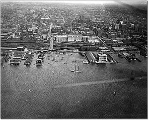
As the city of Toronto grew the northern shore of the bay was further altered by landfill, and has been moved approximately 500 metres south. After the Esplanade landfill, the second landfill project extended the shoreline south of today's Queens' Quay to the west of Yonge Street. The final infill on the north shore was in the 1950s, from Yonge Street east to the Don River, providing room for the Redpath Sugar Refinery, the Victory Soy Mills and several marine terminals.
In the 1920s, most of the low-lying marsh of Ashbridge's Bay was filled in to create Toronto's inner harbour area (with the small section to the east and the shipping channel the only reminder of the body of water). In the 1930s, the waters of Hanlan's Bay on the western point of the islands were infilled to create the Toronto Island Airport.
By the time that the plans to build the St. Lawrence Seaway were announced, commercial usage of the harbour was already in decline. Previous infill on the eastern side created in the 1920s was used to build modern port facilities. In the 1970s, the northern shore was in decline and there was a new political initiative to rebuild the waterfront without industry in a manner seen in other cities. The Harbourfront project expropriated the lands west of York Street. Several facilities were renovated, such as the Terminal Warehouse, and others were demolished, creating space for recreational and cultural uses. The area around Yonge Street remained in private possession and a hotel and condominiums were built on the shoreline. The area east of Yonge Street remained in light industrial use under public possession. On the north side of the harbour, there are a few buildings left from the industrial period. Some are in use, such as the Redpath Sugar Refinery. Others have been demolished or are slated for demolition, including grain storage elevators at the east and west end of the harbours.
Starting in 1972, the Government of Canada spent $10 million to dredge and widen the Eastern Gap, making it the primary entrance to the harbour for commercial boats. The 10 billion cubic yards of material was used to build the aquatic park on the Outer Harbour headland.[17]
The original area of the harbour in 1834 was estimated to be about 2,150 acres (870 ha). With infilling, the area has declined to an area of 1,210 acres (490 ha) in size.[18]
Rochester ferry service
In June 2004, the company Canadian American Transportation Systems (CATS) began regular passenger/vehicle ferry service between Pier 52 and Rochester, New York using the vessel Spirit of Ontario I. The service used a marketing name called "The Breeze". While Rochester had a custom-built ferry terminal, the Toronto terminal was a temporary facility, near the end of Cherry Street for security and customs screening facilities while a permanent marine passenger terminal was still under consideration for construction. CATS discontinued the service after only 11 weeks; among the problems cited was the absence of a permanent marine passenger terminal in Toronto and little Canadian interest in the service. The vessel was sold in a bankruptcy sale in February 2005 to Rochester Ferry Company LLC, a subsidiary of the City of Rochester. In April 2005, Rochester Ferry Company LLC announced that the Rochester-Toronto ferry service using Spirit of Ontario I would return, operated by Bay Ferries Great Lakes Limited and using the marketing name The Cat. The Toronto Port Authority officially opened the International Marine Passenger Terminal on June 27, 2005, three days before ferry service resumed.[19] Even with impressive passenger numbers by the winter of 2006 the ferry service lost funding from the City of Rochester and announced that it would no longer be in business. The terminal building was later used for filming the CBC crime drama The Border.
Wharves and piers
Wharves existed along Toronto's waterfront in the 19th century, but they have since been replaced by quays. Most of the former wharves disappeared when the waterfront was filled in along with the now "missing" creeks of Toronto.
A list of former wharves along the central waterfront:
- Allan's/Merchant's Wharf - Frederick Street[20]
- Commissariat Wharf - Peter Street[20]
- Conner's Wharf - York Street
- Cooper's/Feighan's/Maitland's Wharf - Church Street[20]
- Dufferin Street Wharf
- Gooderham's Wharf and Elevator - Don River
- Hamilton Wharf - Church Street
- Higginbotham's Wharf - Yonge Street
- Hogarty and Grussett Wharf and Elevator - Simcoe Street
- Manson's Wharf - Market Street
- Millous Wharf - Yonge Street
- King's/Navy Wharf - between John and Peter Streets[20]
- Northern Railway Wharf and Elevator - Portland Street
- Queen's Wharf - Bathurst Street
- Sylvester Brothers and Hickman's Wharf - Church Street
- Taylor's Wharf - George Street
- Tinning's Wharf - York Street
- Toronto and Northern Railway Wharf - Berkeley Street
- Walsh and Love's Wharf - Simcoe Street
A list of current quays/slips along the waterfront:
- Bathurst Quay
- Maple Leaf Quay
- John Quay
- York Quay
- Queen's Quay
- Yonge Quay
- Rees St. Slip
- Simcoe St. Slip
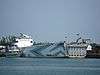
Ships of Toronto Harbour
Vessels found or associated with Toronto Harbour include:
| image | name | first arrival | last departure | notes |
|---|---|---|---|---|
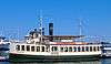 | Oriole | 1987 | ||
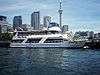
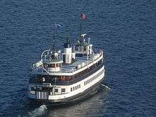
| Jubilee Queen |
| |||
| Aurora Borealis |
| |||
| Showboat Royal Grace |
| |||
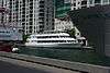 | The Empress of Canada | 1989 | ||
| | MS Jadran | 2015 |
| |
 | Miss Toronto | 1955 |
|
| image | name | first arrival | last departure | notes |
|---|---|---|---|---|
 | Mayflower | 1890 | 1938 | |
 | Primrose | 1890 | 1938 | |
| William Inglis | ||||
 | Sam McBride |
| ||
 | Ongiara |
| ||
 | Thomas Rennie | |||
 | Trillium | 1910 |
| |
 | Windmill Point |
| ||
 | MV Kwasind | 1910 |
| |
 | David Hornell |
| ||
 | Marilyn Bell I |
| ||
 | Maple City | 1965 |
|
| image | name | first arrival | last departure | notes |
|---|---|---|---|---|
 | Charles A. Reed |
| ||
.jpg) | Fred Sandretti | |||
| G. R. Geary | 1912 | 1966 |
| |
 | G.W. Rogers | |||
| J. C. Stewart | 1915 | 1965 |
| |
 | Kenneth A. |
| ||
 | Menier Consol | 1982 |
| |
.jpg) | M. R. Kane |
| ||
 | Ned Hanlan | 1932 | 1967 |
|
| Ned Hanlan II | 1966 |
| ||
| Rat | 1914 | 1926 |
| |
| Rouille | 1929 | 1949 |
| |
.jpg) | Sora |
| ||
 | William Lyon Mackenzie |
| ||
 | William Rest | 1961 |
|
See also
References
- Hounsom, Eric Wilfrid (1970). Toronto in 1810. Toronto, Ontario: Ryerson Press. ISBN 0770003117.
- Wickson, Ted (2002). Reflections of Toronto Harbour. Toronto, Ontario: Toronto Port Authority. ISBN 0973000201.
- Toronto Harbour Commission Public Affairs Department (1985). Toronto Harbour – The Passing Years. Toronto, Ontario: Toronto Harbour Commissioners.
- Notes
- ↑ http://theairlinewebsite.com/index.php/topic/389297-toronto-island-tunnel-wont-stay-dead/
- ↑ Transportation in Canada 2008 (PDF). Transport Canada. p. A106.
- ↑ "2004-2005 Annual Report on Port Divestiture and Operations". Transport Canada. January 2006. Retrieved 2006-08-02.
- ↑ "Shipping in Canada, 2003" (PDF). Statistics Canada. May 2005. Retrieved 2006-08-02.
- 1 2 Wickson 2002, p. 30.
- ↑ Wickson 2002, p. 21.
- ↑ Wickson 2002, p. 23.
- ↑ Wickson 2002, p. 24.
- ↑ Wickson 2002, p. 26.
- ↑ Wickson 2002, p. 27.
- 1 2 Wickson 2002, p. 25.
- ↑ Wickson 2002, pp. 27–28.
- ↑ Wickson 2002, pp. 28–29.
- ↑ Wickson 2002, p. 35.
- ↑ http://publish.yorku.ca/~mmoir/Shipbuilding%20and%20the%20Waterfront%20Plan%20of%201912.pdf
- ↑ Wickson 2002, p. 36.
- ↑ Baker, Alden (May 18, 1972). "Ottawa to dredge wider Eastern Gap". Toronto Globe and Mail. p. 5.
- ↑ Baker, Alden (August 18, 1970). "Endless problems in production of a waterfront plan for Toronto". Toronto Globe and Mail. p. 4.
- ↑ democratandchronicle.com | Democrat and Chronicle
- 1 2 3 4 Hounsom 1970, p. 11.
- 1 2 3 Amy Pataki (2012-08-03). "What's the food like aboard three Toronto harbour cruise ships?". Toronto Star. Archived from the original on 2013-06-25. Retrieved 2014-10-04.
I’m aboard the Jubilee Queen, a faux showboat with a full complement of passengers drawn from the GTA and beyond.
- ↑ www.empressofcanada.com
- ↑ www.accessenglish.com
- ↑ www.chartermisstoronto.com
| Major ports | |
|---|---|
| Prominent ports | |
| Other ports | |
| Features | |||||||
|---|---|---|---|---|---|---|---|
| History |
| ||||||
| Geography | |||||||
| Economy | |||||||
| Politics |
| ||||||
| Public services | |||||||
| Education | |||||||
| Culture |
| ||||||
| Transportation |
| ||||||
| |||||||
Coordinates: 43°38′00″N 79°22′21″W / 43.633224°N 79.37244°W
 |
Harbourfront, Toronto | | ||
| Half Moon Bay Western Channel Humber Bay |
|
Ashbridge's Bay and Coatsworth Cut Toronto Outer Harbour | ||
| ||||
| | ||||
| Lake Ontario |
Great Lakes of North America | ||
|---|---|---|
| Main lakes | 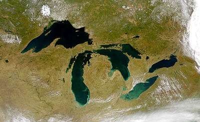 | |
| Secondary lakes | ||
| Bays and Waterways |
| |
| Islands | ||
| Historic geology | ||
| Government | ||
| Related topics |
| |