Totternhoe Knolls
| Site of Special Scientific Interest | |
 | |
| Area of Search | Bedfordshire |
|---|---|
| Grid reference | SP979220 |
| Interest | Biological |
| Area | 13.1 hectares |
| Notification | 1985 |
| Location map | Magic Map |
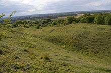
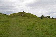
Totternhoe Knolls is a 13.1 hectare Site of Special Scientific Interest (SSSI) in Totternhoe in Bedfordshire.[1][2] It is also a Local Nature Reserve,[3][4] and part of the Chilterns Area of Outstanding Natural Beauty.[5] The site is owned by Central Bedfordshire Council and leased to the National Trust. Most of the site is maintained jointly by the National Trust and the Wildlife Trust for Bedfordshire, Cambridgeshire and Northamptonshire (WTBCN), and is part of the WTBCN Totternhoe nature reserve, which also includes Totternhoe Chalk Quarry and Totternhoe Stone Pit. The SSSI also includes Totternhoe Castle, the earthworks of a Norman motte-and-bailey castle which is a Scheduled Monument.[6][7]
Part of the site was formerly quarry workings for Totternhoe stone, a strong chalk that was used in Westminster Abbey. It is now grassland with a rich variety of plant species, including some that are now rare. There are a number of orchids and a wide variety of invertebrates, including butterflies such as the common blue, chalkhill blue, and the scarce small blue and Duke of Burgundy.[1][6][3]
Totternhoe Castle was probably built in the late eleventh century. Only the earthworks survive, with a mound five metres tall and 40 metres wide. It is unusual in having three baileys.[7]
There is access from the National Trust car park off Castle Hill Road.
| Wikimedia Commons has media related to Totternhoe Knolls. |
References
- 1 2 "Totternhoe Knolls citation" (PDF). Sites of Special Scientific Interest. Natural England. Retrieved 10 September 2015.
- ↑ "Map of Totternhoe Knolls". Sites of Special Scientific Interest. Natural England. Retrieved 10 September 2015.
- 1 2 "Totternhoe Knolls". Local Nature Reserves. Natural England. Retrieved 10 September 2015.
- ↑ "Map of Totternhoe Knolls". Local Nature Reserves. Natural England. Retrieved 10 September 2015.
- ↑ Langslow, Derek. The Chilterns. English Nature. p. 39.
- 1 2 "Totternhoe". Wildlife Trust for Bedfordshire, Cambridgeshire and Northamptonshire. Retrieved 10 September 2015.
- 1 2 "Totternhoe Castle: a motte and bailey castle, medieval quarries and cultivation terraces". Historic England. Retrieved 10 September 2015.
Coordinates: 51°53′07″N 0°34′08″W / 51.8852°N 0.5688°W
External links
- BBC Beds, Herts and Bucks, Totternhoe Knolls.