Cedarburg (town), Wisconsin
| Town of Cedarburg, Wisconsin | |
|---|---|
| Town | |
 | |
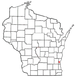 Location of Cedarburg (town), Wisconsin | |
| Coordinates: 43°19′8″N 88°0′15″W / 43.31889°N 88.00417°WCoordinates: 43°19′8″N 88°0′15″W / 43.31889°N 88.00417°W | |
| Country | United States |
| State | Wisconsin |
| County | Ozaukee |
| Area | |
| • Total | 25.8 sq mi (66.9 km2) |
| • Land | 25.6 sq mi (66.3 km2) |
| • Water | 0.2 sq mi (0.6 km2) |
| Elevation[1] | 886 ft (270 m) |
| Population (2000) | |
| • Total | 5,744 |
| • Density | 224.4/sq mi (86.7/km2) |
| Time zone | Central (CST) (UTC-6) |
| • Summer (DST) | CDT (UTC-5) |
| Area code(s) | 262 |
| FIPS code | 55-13400[2] |
| GNIS feature ID | 1582937[1] |
| Website |
town |
Cedarburg is a town in Ozaukee County, Wisconsin, United States. The population was 5,744 at the 2000 census. The City of Cedarburg is located partially within the town. The unincorporated communities of Decker Corner, Hamilton, and Horns Corners are also located in the town.
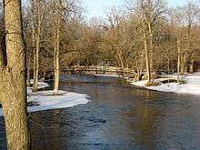
Last Covered Bridge in Wisconsin
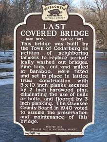
The state of Wisconsin once had over 40 covered bridges throughout the countryside. Today, the last remaining covered bridge resides in the Town of Cedarburg. Location is just 3 miles north of the City of Cedarburg near the Hwy 60 and County Highway NN junction on Covered Bridge Road.
"This bridge was built by the Town of Cedarburg on petition of neighboring farmers to replace periodically washed out bridges. Pine logs, cut and milled at Baraboo, were fitted and set in place in lattice truss construction with 3x10 inch planks secured by 2-inch (51 mm) hardwood pins, eliminating the use of nails or bolts, and floored by 3-inch (76 mm) plating. The Ozaukee County Board in 1940 voted to assume the preservation and maintenance of this bridge."
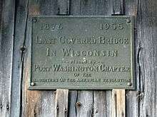
On October 1, 1955, the Port Washington Chapter of the Daughters of the American Revolution added a plaque to the bridge that reads "1876-1955 Last Covered Bridge in Wisconsin"


Geography
According to the United States Census Bureau, the town has a total area of 25.8 square miles (66.9 km²), of which, 25.6 square miles (66.3 km²) of it is land and 0.2 square miles (0.6 km²) of it (0.93%) is water.
Demographics
As of the census[2] of 2000, there were 5,744 people, 1,896 households, and 1,662 families residing in the town. The population density was 224.4 people per square mile (86.7/km²). There were 1,931 housing units at an average density of 75.5 per square mile (29.1/km²). The racial makeup of the town was 98.85% White, 0.16% Black or African American, 0.17% Native American, 0.37% Asian, 0.10% from other races, and 0.35% from two or more races. 0.66% of the population were Hispanic or Latino of any race.
There were 1,896 households out of which 41.8% had children under the age of 18 living with them, 82.5% were married couples living together, 3.0% had a female householder with no husband present, and 12.3% were non-families. 10.0% of all households were made up of individuals and 4.0% had someone living alone who was 65 years of age or older. The average household size was 2.93 and the average family size was 3.15.
In the town the population was spread out with 28.1% under the age of 18, 4.7% from 18 to 24, 25.3% from 25 to 44, 29.9% from 45 to 64, and 12.1% who were 65 years of age or older. The median age was 41 years. For every 100 females there were 99.3 males. For every 100 females age 18 and over, there were 95.7 males.
The median income for a household in the town was $75,909, and the median income for a family was $81,416. Males had a median income of $56,113 versus $33,480 for females. The per capita income for the town was $30,998. About 1.4% of families and 2.3% of the population were below the poverty line, including 3.8% of those under age 18 and 0.8% of those age 65 or over.
Notable people
- William Henry Fitzgerald, Wisconsin State Assemblyman, was born in the town prior to Wisconsin's statehood.[3]
- Eugene J. Poole, Wisconsin State Assemblyman, was born in the town.[4]
References
- 1 2 "US Board on Geographic Names". United States Geological Survey. 2007-10-25. Retrieved 2008-01-31.
- 1 2 "American FactFinder". United States Census Bureau. Archived from the original on 2013-09-11. Retrieved 2008-01-31.
- ↑ THE BLUE BOOK OF THE STATE OF WISCONSIN (18th ed.). Madison, Wis.: David Atwood. 1879. p. 501.
- ↑ 'Wisconsin Blue Book 1917,' Biography of Eugene J. Poole, pg. 546
External links
Municipalities and communities of Ozaukee County, Wisconsin, United States | ||
|---|---|---|
| Cities | 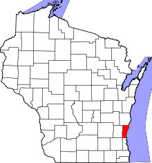 | |
| Villages | ||
| Towns | ||
| CDP | ||
| Unincorporated communities | ||
| Footnotes | ‡This populated place also has portions in an adjacent county or counties | |