Trans-Amazonian Highway
| |
|---|---|
|
Map of BR-230 (paved portion shown in red)[1] | |
|
Trans-Amazonian highway within the city of Pombal, Paraíba. | |
| Highway system | |
|
Highways in Brazil |

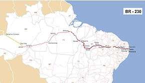

The Trans-Amazonian Highway (official designation BR-230, official name Rodovia Transamazônica), was introduced on September 27, 1972. It is 4,000 km long, making it the third longest highway in Brazil. It runs through the Brazilian states of Paraíba, Ceará, Piaui, Maranhão, Tocantins, Pará and Amazonas, from the proximities of Saboeiro up until the town of Lábrea.
History
The highway was intended to integrate these regions with the rest of the country, and with Colombia, Peru and Ecuador. Another main goal of the project was to alleviate the effects of the drought affecting the Northeast region of the country by providing a route to largely empty land in the middle of the rainforest, which could be settled.[2] It was originally planned to be a fully paved highway 5200 kilometers long. However, these plans were modified following its inauguration.[3]
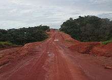
In particular, because of high construction costs and Brazil financial crisis in the late 1970s, only a part of the highway was paved, from its beginning to 200 km ahead of Marabá. The lack of a fully sealed road caused many problems. Travel on the non-paved stretches of the highway is extremely difficult during the region's rainy season between October and March.[4] In the wet season cars often get stuck in the poorly constructed road and in the dry season there are often pot holes in the dry mud roads that damage vehicles.
Construction of the highway was very challenging because of the remoteness of the site. Workers building the road were frequently isolated and without communication. Occasional visits to nearby cities provided the only outside contact. However, severe techniques and procedures that evolved during the construction of Belém-Brasília Highway (BR-153) were then used. According to DNIT, roughly 800 km of the highway is due to be paved in the next 4 years, improving transport links in the central region of Pará state. The Brazilian Government are now planning to pave with tarmac the whole highway. As of December 2009, paving was underway between the town of Ruropolis and Itaituba and north to Santarém. This will connect soy plantations with overland trucking routes to the south of Brazil. The road has been left untouched however at points further west of Itaituba, at times narrowing to roughly 2 meters wide.
Access to the construction sites was mostly accomplished by small airplanes using temporary airstrips and boats. Today construction vehicles can be seen traversing the road east and west bringing dirt and gravel to prepare for paving operations.[5]
Deforestation and conservation
It has indirectly caused a great deal of deforestation in Brazil[6] - where there are roads it is easier to transport timber. Satellite images demonstrate how roads increase deforestation. Access roads branch perpendicularly off BR-230 allowing deeper penetration into the surrounding jungle areas. Originally these roads were to open up land for agriculture by settlers, the government motto "land without men for men without land"[7] was coined to describe the development of the Amazon. However, loggers have used these roadways to further deforest the surrounding jungle.
Various conservation units have been created along the route of the highway in an effort to halt deforestation or manage forestry in a sustainable manner. In the western section from Lábrea to Humaitá the fully protected Mapinguari National Park is south of the highway and the sustainable use Balata-Tufari National Forest is to the north.[8] East of Humaitá the Humaitá National Forest lies to the south of the highway, then the Campos Amazônicos National Park and Juruena National Park. [9]
See also
References
- ↑ "Nova pagina 1". .transportes.gov.br. Retrieved 2014-02-05.
- ↑ Nigel J.H. Smith. "Brazil's Transamazon Highway Settlement Scheme" (PDF). College of Liberal Arts and Sciences, The University of Florida. Retrieved 2014-02-05.
- ↑ Canada. "From Nothing to Nowhere — The Transamazonian Highway". New Internationalist. Retrieved 2014-02-05.
- ↑ "Amazon Brazil Tours". Brazil-travel-guide.com. Retrieved 2014-02-05.
- ↑ "Pacas That Go Bump in the Night". Amazonpilgrim.com. 2009-10-10. Retrieved 2014-02-05.
- ↑ Skole, D.L., W.H. Chomentowski, W.A. Salas, and A.D. Nobre (1994). "Physical and Human Dimensions of Deforestation in Amazonia". BioScience. 44 (5): 314–322. doi:10.2307/1312381.
- ↑ Archived June 25, 2012, at the Wayback Machine.
- ↑ Flona de Balata-Tufari Mapa Interativo (in Portuguese), ICMBio, retrieved 2016-06-03
- ↑ Flona de Humaitá - Mapa Interativo (in Portuguese), retrieved 2016-06-03