Treasure Island, San Francisco
| Treasure Island Magic Isle[1] | |
|---|---|
| Landform and neighborhood | |
|
Treasure Island is "5,520 feet long by 3,410 feet wide"[1] and has the Treasure Island Marina on the south near Yerba Buena Island (bottom) | |
.svg.png) Treasure Island is the northernmost area of San Francisco's District 6 | |
 Treasure Island Location within San Francisco | |
| Coordinates: 37°49′30″N 122°22′16″W / 37.825°N 122.371°WCoordinates: 37°49′30″N 122°22′16″W / 37.825°N 122.371°W | |
| Country |
|
| State |
|
| City-county | San Francisco |
| Constructed | 1936–37 |
| Named for | Treasure Island (novel) |
| Government | |
| • Supervisor | Jane Kim (Dist. 6) |
| • Assemblymember | David Chiu (D)[2] |
| • State senator | Scott Wiener (D)[2] |
| • U. S. rep. | Nancy Pelosi (D)[3] |
| Area[4] | |
| • Total | 0.9 sq mi (2 km2) |
| • Land | 0.9 sq mi (2 km2) |
| • Water | 0 sq mi (0 km2) 0% |
| Population (2011 estimate)[4] | |
| • Total | 2,300 |
| • Density | 2,600/sq mi (990/km2) |
| Time zone | Pacific (UTC-8) |
| • Summer (DST) | PDT (UTC-7) |
| ZIP code | 94130 |
| Area codes | 415/628 |
| GNIS feature IDs[5] |
236528 (island) 2624152 (Building 157) 2506912 (Job Corps Ctr) |
| Wikimedia Commons | Treasure Island, California |
| Website | Treasure Island Development Authority |
| Reference no. | 987[6] |

Treasure Island is an artificial island in San Francisco Bay and a neighborhood of the City of San Francisco. Built 1936–37 for the 1939 Golden Gate International Exposition, the island's World’s Fair site is a California Historical Landmark.[6] Buildings there have been listed on the National Register of Historic Places, and the historical Naval Station Treasure Island and auxiliary air facility (for airships, blimps, dirigibles, planes and seaplanes) are designated in the Geographic Names Information System.[5]
Geography
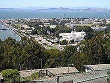
The San Francisco neighborhood that includes Treasure Island extends far into San Francisco Bay and includes a tip of Alameda Island.[7] Yerba Buena and Treasure islands together have a land area of 576.7 acres (233.4 ha) with a 2010 total population of 2,500.[8] Treasure Island and its 900 ft (270 m) causeway[9] total 535 acres (217 ha) connected by roadway to Yerba Buena Island which has the Transbay Terminal ramps to the middle of Interstate 80's San Francisco–Oakland Bay Bridge.
The island has a marina and a bikeway connecting to the newly completed Eastern span replacement of the San Francisco–Oakland Bay Bridge. Raised walkways circumscribe nearly the entire island along five streets (Avenue of the Palms, Perimeter Road, Avenue N, Pan American World Airways Esplanade and Clipper Cove Way, formerly known as 1st Street).
History
Prior to the island's construction by the United States government, "Yerba Buena Shoals" of rock[1] north of the transbay island had less than 27 ft (8.2 m) clearance and were a shipping hazard.[9] The 400-acre (1.6 km2) island was constructed by emplacing 287,000 short tons (260,000 t) of quarried rock in the shoals for the island/causeway perimeter rock walls (a freshwater reservoir was quarried in the rock of Yerba Buena Island).[9] Approximately 23 feet (7.0 m) of dredged bay sand filled the interior, was mitigated from salt, and then 50,000 cubic yards (38,000 m3) topsoil[9] was used for planting 4,000 trees, 70,000 shrubs, and 700,000 flowering plants.[1] Facility construction had begun by March 4, 1937 when two hangars were being built.
| Images | |
|---|---|
|
| |
| Video | |
|
|
On Monday, February 18, 1939, the 'Magic Isle'" opened[1] with a "walled city" of several fair ground courts: a central Court of Honor, a Court of the East, a Port of Trade Winds on the south and on the north: a Court of Pacifica, a 12,000-car parking lot, and the adjacent Midway (fair) of 40 acres (16 ha) with thrill rides and shows.[9] The island had a lagoon ("Lake of All Nations"), and structures included the "400-foot Tower of the Sun" (with reflecting pools), the International Building, the $1.5M Federal Building, the Hall of Western States, the $800K administration building, various exhibit halls for industries (e.g., "Machinery, Science, and Vacationland"), and two 335-by-78-foot (102 m × 24 m) hangars planned for post-exposition use by Pan Am flying boats (e.g., the China Clipper through 1944[6]) using the Port of Trade Winds Harbor later referred to as Clipper Cove between the two islands. In addition to Building 2 (Hangar 2) and Building 3 (Hangar 3), remaining exposition buildings include Building 1 (Streamline Moderne architecture) intended after the expo as the Pan American World Airways terminal. The expo's Magic Carpet Great Lawn also remains.)[10]
A couplet from the song "Lydia the Tattooed Lady", in the Marx Brothers' 1939 film, At The Circus, reads "Here is Grover Whalen unveilin' the Trylon/Over on the West Coast we have Treasure Island", citing, in the Trylon and Treasure Island, two prominent features of international civic events happening that year (as the 1939 New York World's Fair vied for tourist patrons with the Golden Gate International Expo).
Military base
Naval Station Treasure Island began under a 1941[11] war lease as a United States Navy "reception center"[12] and in 1942, the Navy offered to exchange its Mills Field on the San Francisco Peninsula for the island. The U.S. Navy seized Treasure Island on April 17, 1942[11] and instead of an island airport, the city built an airport at Mills Field that became the San Francisco International Airport (the naval station closed in 1997).
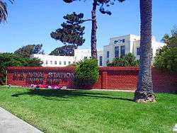
The station had a Naval Auxiliary Air Facility[5] to support helicopters, fixed wing planes, seaplanes, blimps, dirigibles and airships. And a U.S.Navy/USMC electronics school. In the '70s, '80s, and '90s the U.S.Navy Conducted Naval Technical Training NTTC . Training Hull Maintenance Technicians. The U.S.Navy Rate consisted of the old Steel Worker Rate and Damage Control Technicians. The U.S.Navy Technical Training also included NBC Warfare Decon. The New U.S.Navy Rate was classified as HT Hull Maintenance Technicians. Multiple Maintenance Skills were included into The Naval Technical Training Command NTTC.[13] During World War II over 12,000 men a day were processed here for Pacific area assignments, and thousands more were processed for separation in the aftermath of the war.[14] In recognition of his naval base leadership and development efforts since the inception of US Naval Station Treasure Island, Rear Admiral Hugo Wilson Osterhaus Square was established in front of Building 1 Administration Building, Treasure Island. Medal of Honor and Navy Cross recipient USMC Gunnery Sgt John Basilone movie theatre Building 401 @ 680 Avenue I was established in recognition as being one of the earliest World War II heroes. The station was identified by the 1991 Base Realignment and Closure Commission, and remaining military structures include Bldg. 600 @ 750 Avenue M (former Naval Firefighting School, now SFFD's Treasure Island Training Facility & Temporary SFFD Fire Station 48), Bldg. 157 (Navy Fire station 2 built circa 1942 wood frame building which lacks modern earthquake Seismic retrofit) @ 849 Avenue D (SFFD Station 48 closed March 7, 2014 due to health hazards & excessive deferred maintenance), and the 20,000 sq ft (1,900 m2) Bldg. 180 by US Naval Station Way & California Ave (now a winery).[15]
SAC radar station
The Treasure Island Radar Bomb Scoring Site (call sign San Francisco Bomb Plot)[16] was a Strategic Air Command (SAC) automatic tracking radar facility established on the island. Major Posey was the c. 1948 commander[17] of Detachment B (Capt Carlson on August 1, 1949)[18] which evaluated simulated bombing missions on targets in the San Francisco metropolitan area for maintaining Cold War bomber crews' proficiency. A nearby "Stockton Bomb Plot (Det I)" moved to Charlotte in 1950, and the Treasure Island unit was redesignated Detachment 13 in 1951, the year 3 other SAC detachments used a nearby staging/preparation area for deploying via the bay for Korean War ground-directed bombing (cf. the Sacramento Bomb Plot at a McClellan AFB Annex in 1951.)[17] On October 16, 1951, Treasure Island's Det 13 was assigned under March AFB's 3933rd Radar Bomb Scoring Squadron before moving from the island by August 10, 1954 when the 11th RBS Squadron was activated.
Film stages and settings
From the late 1980s, Treasure Island's old aircraft Hangar 2 (Building 2) and Hangar 3 (Building 3) served as sound stages for film-making and TV, e.g., The Matrix ("bullet time" visual effect), Rent, and The Pursuit of Happyness. Treasure Island was a film setting of the 1939 Charlie Chan at Treasure Island, 1988 Indiana Jones and the Last Crusade (Berlin airport scene), 1995 Copycat (private compound), 1997 Flubber, 1998 What Dreams May Come, 1998 Patch Adams, 1998 The Parent Trap and 1999 Bicentennial Man. An establishing shot of the 1954 The Caine Mutiny shows the main gate and Administration Bldg 1 to indicate the location of the fictitious court martial. For three years Treasure Island served as the site of the Battlebots TV show. The offices and penthouse apartment sets in Nash Bridges were located on the island during the show's production (1996–2001).[21] The island was featured as the base of operations for the prototypers in the 2008 Discovery Channel series Prototype This!. Building 180 (warehouse) and Building 111 (former firehouse) on Treasure Island served as film settings for an NBC series titled Trauma.
Remediation and redevelopment
Cleanup crews spent several weeks cleaning the island's coast from the 2007 Cosco Busan oil spill just a few hundred yards from Treasure Island, and the Navy sold the island to the city for $108 million as part of a redevelopment project. The Federal government still maintains an active presence on 40 acres (16 ha) occupied by the United States Department of Labor Job Corps (not part of the redevelopment). The Job Corps moved in and took over 40 acres (16 ha) and 13 building facilities just after the US Navy vacated the island. The Administration Building (Bldg. 1) and Hall of Transportation (Bldg. 2) were listed in the National Register of Historic Places in 2008. On June 8, 2011, the San Francisco Board of Supervisors approved new neighborhood development for 19,000 people over the next 20–30 years by Wilson Meany Sullivan, Lennar Urban, and Kenwood Investments.[22] The 2012-2014 US$1.5 billion Treasure Island Development project for up to 8,000 new residences, 140,000 sq ft (13,000 m2) of new commercial and retail space, 100,000 sq ft (9,300 m2) of new office space, 3 hotels, new Fire station and 300 acres (120 ha) of parks.[23] The island's gas station pumps and canopy were also removed (the island has a high risk of soil liquefaction and tsunami damage in an earthquake). All island natural gas, electricity, sewer and water utilities are serviced by the San Francisco Public Utilities Commission.
By December 17, 2010, "Navy contractors had dug up and hauled off 16,000 cubic yards [12,000 m3] of contaminated dirt, some with radiation levels 400 times the Environmental Protection Agency’s human exposure limits for topsoil."[24] The contaminated dirt is to be replaced by dirt removed during construction of the fourth Caldecott Tunnel bore. In April 2013, caesium-137 levels three times higher than previously recorded were found (the island hosted "radioactive ships from Bikini Atoll atomic tests and [was] a major education center training personnel for nuclear war"[25]—the USS Pandemonium (PCDC-1)[26] mockup had begun nuclear training in 1957.[27][28]
Water supply
The main waterlines under the causeway are backed up by yellow above-ground emergency manifolds to which blue six-inch (150 mm) diameter hose can be connected from a large hose spool affixed to a San Francisco Public Utilities Commission / SF Water Dept' mobile truck dispatched from the SFWD Newcomb Avenue Yard after an earthquake provided the Bay Bridge from SF to Treasure Island is still operational.
Gallery
|


See also
- Naval Station Treasure Island
- Treasure Island Development
 San Francisco Bay Area portal
References
- 1 2 3 4 5 6 McGloin, John Bernard. "Symphonies in Steel: Bay Bridge and the Golden Gate". The Virtual Museum of the City of San Francisco (SFmuseum.net). Retrieved October 22, 2013.
The Secretary of War approved the request that its execution be undertaken by the Army Corps of Engineers. While a group of such specialists applied their talents to the reclamation of the 'Yerba Buena Shoals', the day-by-day details were efficiently cared for by Colonel Fred Butler, U.S.A., who had years of army engineering experience behind him at this time. The fill to form Treasure Island was obtained by dredging operations; the island covered an area of 400 acres [160 ha], 5,520 feet [1,680 m] long by 3,410 feet [1,040 m] wide.
- 1 2 "Statewide Database". UC Regents. Retrieved November 5, 2014.
- ↑ "California's 12th Congressional District - Representatives & District Map". Civic Impulse, LLC.
- 1 2 "94130 Zip Code (San Francisco, California) Profile: homes, apartments, schools, population, income, averages, housing, demographics, location, statistics, sex offenders, residents and real estate info". City-data.com. Retrieved November 7, 2012.
- 1 2 3
- "Treasure Island (236528)". Geographic Names Information System. United States Geological Survey. Retrieved October 25, 2013. "374929N 1222216W...374937N 1222241W"
- "San Francisco Fire Department Station 48 Treasure Island (2624152)". Geographic Names Information System. United States Geological Survey. Retrieved October 25, 2013. "Building 157...374931N 1222226W"
- "Treasure Island Job Corps Center (2506912)". Geographic Names Information System. United States Geological Survey. Retrieved October 25, 2013.
- "Naval Station Treasure Island (historical)". Geographic Names Information System. United States Geological Survey. Retrieved October 25, 2013.
- "Treasure Island Naval Auxiliary Air Facility (historical) (1988803)". Geographic Names Information System. United States Geological Survey. Retrieved October 25, 2013.
- 1 2 3 Office of Historic Preservation. "San Francisco". California Historical Landmarks. California Department of Parks and Recreation. Retrieved October 26, 2013.
- ↑ "San Francisco Census Tract Outline Map" (PDF) (Map). Census 2000 (PDF). United States Census Bureau. Retrieved December 16, 2013.
- ↑ United States Census, 2010
- 1 2 3 4 5 Workers of the Federal Writers’ Project (1938). "Trail Ends for '39ers". Almanac for Thirty-Niners. San Francisco Works Progress Administration – via SFmuseum.net.
- ↑ "San Francisco Attractions". SF-Attractions.
- 1 2 "Treasure Isle Goes to Navy: City Upset Over Offer, May Dispute Price". The San Francisco News. April 17, 1942. Retrieved October 26, 2013 – via SFmuseum.net.
- ↑ "Treasure Island Accord". The Virtual Museum of the City of San Francisco.
- ↑ "DEV Charlie Marine Air Support Radar Team". The Korean War Project.
- ↑ Lemon, Sue. "Treasure Island, Naval Station, 1937 - ." United States Navy and Marine Corps Bases, Domestic. Paolo E. Coletta, Editor. Westport, CT: Greenwood, 1985.
- ↑ "The Winery SF". Retrieved December 2, 2010.
- ↑ Tim in San Mateo (October 2, 2002). "San Francisco Bomb Plot". Yahoo! Groups. Self-published via Yahoo!. Retrieved October 25, 2013.
- 1 2 "3903rd Radar Bomb Scoring Group" (Web Bulletin Board). KoreanWar.org. Retrieved March 14, 2013.
Detachment 13 Radar Bomb Scoring Group, Threaure Island, San Francisco ... 2nd Lt. Robert F.(?) Schaller who was in our outfit from about '52 th '53 ... 3903 RBS, Treas Island, SF 1948-52...Chief Phillip Martin was assigned to this unit from 1948-1952. The unit was commanded by a Major Posey.
- ↑ Martin, Jack S. (September 23, 1949). Report of Investigation: Project Grudge (Special Inquiry). Fairfield-Suisun Air Force Base: USAF Office of Special Investigations. Retrieved October 26, 2013.
On 14 September 1949, Captain Howard A. Carlson,12456-A/ Detachment Commander, Detachment B, 3903 Radar Bomb Scoring Squadron, Treasure Island, San Francisco, California,was interviewed and stated that on 1 August 1949, two (2) radar testing devices were released; one (1) at approximately 1000 hours, PST, and another at 1400 hours, PST.
- 1 2 "Home". Treasure Island Museum Association. Retrieved July 20, 2008.
- ↑ "The Museum and Its Collection". Treasure Island Museum Association. Retrieved December 16, 2013.
- ↑ SF filming locations for Nash Bridges
- ↑ Kane, Will (June 8, 2011). "S.F. approves Treasure Island plan". The San Francisco Chronicle. Retrieved December 7, 2012.
- ↑ "Treasure Island: Development Project". Treasure Island Development Authority. Retrieved October 11, 2012.
- ↑ Sapunor, Peter (December 17, 2010). "title tbd" (email).
- ↑ Smith, Matt; Mierskowski, Katherine (April 12, 2013). "Soil tests find cesium, linked to cancer risk, up to 3 times higher than previously acknowledged". The Bay Citizen. Retrieved October 26, 2013.
Until the early 1990s, the Navy operated atomic warfare training academies on Treasure Island, using instruction materials and devices that included radioactive plutonium, cesium, tritium, cadmium, strontium, krypton and cobalt. These supplies were stored at various locations around the former base, including supply depots, classrooms and vaults, and in and around a mocked-up atomic warfare training ship—the USS Pandemonium.
- ↑ The Sandusky Register on. Newspapers.com (1957-03-21). Retrieved on 2014-05-10.
- ↑ "Toxic Acres" - Am I Living in Presence of Harmful Nuclear Radiation?. 3dbuzz.com (2006-05-02). Retrieved on 2014-05-10.
- ↑ Ashley Bates, "Radioactive Isle." East Bay Express, September 9, 2012
External links
- Treasure Island Music Festival
 Media related to Treasure Island, San Francisco at Wikimedia Commons

| Downtown | .svg.png) | |
|---|---|---|
| North of Downtown | ||
| Outside Lands | ||
| Western Addition | ||
| Southern | ||
| ||