Sunset District, San Francisco
| Sunset District | |
|---|---|
| Neighborhood | |
|
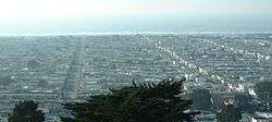
The Outer Sunset from Grand View Park. | |
| Nickname(s): The Sunset, SUNSET 415, Outbound, The Avenues, The Set, Outside Lands | |
 Sunset District Location within San Francisco | |
| Coordinates: 37°45′N 122°29′W / 37.75°N 122.49°W | |
| Country |
|
| State |
|
| City-county | San Francisco |
| Government | |
| • Supervisor | Katy Tang |
| • Assemblymember | Phil Ting (D)[1] |
| • State senator | Scott Wiener (D)[1] |
| • U. S. rep. | Nancy Pelosi (D)[2] |
| Area | |
| • Total | 5.709 sq mi (14.79 km2) |
| • Land | 5.709 sq mi (14.79 km2) |
| Population | |
| • Total | 85,252 |
| • Density | 14,934/sq mi (5,766/km2) |
| Time zone | PST (UTC-8) |
| • Summer (DST) | PDT (UTC-7) |
| ZIP codes | 94116, 94122, 94132 |
| Area codes | 415/628 |
The Sunset District is a neighborhood located in the west-central area of San Francisco, California, United States.
Location
The Sunset District is the largest district within the city of San Francisco, and with a population of over 85,000 it is also the most populous. Golden Gate Park forms the neighborhood's northern border, and the Pacific Ocean (or, more specifically, the long, flat strand of beach known as Ocean Beach) forms its western border. The Sunset District's southern and eastern borders are not as clearly defined, but there is a general consensus that the neighborhood extends no farther south than Sigmund Stern Grove and Sloat Boulevard and no farther east than Stanyan Street (just east of the Parnassus campus of the University of California, San Francisco) and Laguna Honda Hospital. Prior to the residential and commercial development of the Sunset District, much of the area was covered by sand dunes and was originally referred to by 19th century San Franciscans as "the Outside Lands."[3]
The Sunset District and the neighboring Richmond District (on the north side of Golden Gate Park) are often collectively known as The Avenues, because the majority of both neighborhoods are spanned by numbered north-south avenues. When the city was originally laid out, the avenues were numbered from 1st to 49th, and the east-west streets were lettered A to X. In 1909, to reduce confusion for mail carriers, the east-west streets and 1st Avenue and 49th Avenue were renamed. The east-west streets were named in ascending alphabetical order in a southward direction after prominent 19th-century American politicians, military leaders, or explorers; 19th-century Mexican landowners; and Spanish conquistadors. 1st Avenue was renamed Arguello Boulevard, and 49th Avenue was renamed La Playa Street (Spanish for "the beach").[4]
Today, the first numbered avenue is 2nd Avenue, starting one block west of Arguello Boulevard, and the last is 48th Avenue near Ocean Beach. The avenue numbers increase incrementally, with one exception: what would be 13th Avenue is known as Funston Avenue, named after Frederick Funston, a U.S. Army general famous for his exploits during the Spanish–American War and Philippine–American War, and for directing the U.S. Army response to the 1906 earthquake.
The east-west streets in the Sunset appear for the most part in alphabetical order. These streets are: Lincoln Way (bordering the south side of Golden Gate Park), Hugo (from Arguello to 7th Avenue only), Irving, Judah, Kirkham, Lawton, Moraga, Noriega, Ortega, Pacheco, Quintara, Rivera, Santiago, Taraval, Ulloa, Vicente, Wawona, Yorba, and Sloat Boulevard. "X" was originally proposed to be Xavier, but was changed to Yorba due to a pronunciation controversy.[4]
History

The origin of the "Sunset" name is not entirely clear. One claim indicates that Aurelius Buckingham, a developer who owned property in the area, coined the term in 1886. Another claim comes from the California Midwinter Exposition, held in Golden Gate Park in 1894 and also known as "The Sunset City." [3]
Before construction of the Twin Peaks Tunnel in 1917, the Sunset was a vast, sparsely inhabited area of large sand dunes and coastal scrub land known as the "Outside Lands." Development was initiated in the 1870s and 1880s with construction of Golden Gate Park, but it did not reach a full scale until after the 1906 San Francisco earthquake, when small lots of tract homes and row homes now characteristic of the neighborhood were built into the sand dunes.[5] These tract homes would displace a smaller original settlement built into the dunes called Carville, which was so named for squatters that lived in abandoned streetcars that were dumped in the sand dunes.[6] Development increased by the 1930s, as the Sunset was built and developed into a streetcar suburb. The post–World War II baby boom in the 1950s saw the last of the sand dunes leveled down and replaced with more single- and multifamily homes. In these developments, built mostly by Henry Doelger, entire blocks consist mainly of houses of the same general character, differentiated by variations in their stucco facades and mirrored floorplans, with most built upon 25-foot-wide (7.6 m) lots with no free space between houses. Later, Oliver Rousseau built more individualistic homes in the district.[7]
Segments
For most of its history, the Sunset existed as a large individual area. In recent years, the neighborhood has been popularly divided into four parts with sometimes vague borders.
Inner Sunset

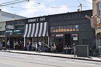
The Inner Sunset is bordered by Lincoln Way to the north, Arguello Boulevard to the east, Quintara Street to the south, and 19th Avenue to the west. This far-east section of the Sunset is located just west of Mount Sutro. The main commercial area is along Irving Street from 5th Avenue to 10th Avenue, which is dotted with a variety of restaurants and shops. The Inner Sunset is the least foggy part of the predominantly foggy neighborhood.
The Inner Sunset is a unique part of San Francisco that hosts a variety of local businesses, including restaurants, bars, book stores, bakeries, coffee shops, ice cream parlors, clothes and shoe stores, a tattoo parlor, and a wine bar. All these establishments are clustered around the intersection of 9th. Avenue and Irving Street. There is a great deal of gastronomic diversity in the restaurants located in the Inner Sunset: Pizza, Mexican, Thai, Chinese, Vietnamese, California Cuisine, Mediterranean, Indian, Japanese, Vegetarian.
Central Sunset
The Central Sunset is bounded by Lincoln Way to the north, 19th Avenue to the east, Quintara Street to the south, and Sunset Boulevard to the west. This area is mostly residential with a commercial strip along Irving Street from 19th Avenue to 24th Avenue and on Noriega Street from 19th Avenue to 27th Avenue and 30th Avenue to 33rd Avenue. Features of the area include the massive Sunset Reservoir (which takes up eight square blocks between Ortega and Quintara streets and 24th and 28th avenues), which has a small park surrounding its outer rim; Golden Gate Park; the Sunset Recreation Center; and Abraham Lincoln High School.
Outer Sunset
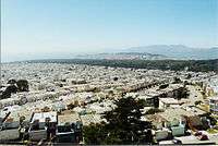
The Outer Sunset is bordered by Lincoln Way to the north, Sunset Boulevard (between 36th and 37th avenues) to the east, Sloat Boulevard to the south, and Ocean Beach to the west. The primary commercial avenues are Judah, Noriega, and Taraval. The Outer Sunset is the foggiest section in San Francisco due to its close proximity to Ocean Beach. The area's main attractions include the San Francisco Zoo, Golden Gate Park, Ocean Beach, and Lake Merced.
Attractions and characteristics

The western part of the Sunset borders the cold northern Californian Pacific Ocean coastline, so it tends to get much of the fog San Francisco is famous for. The Sunset can be foggy and chilly for many consecutive days during summer. The Sunset's finest weather is usually from mid-September through October, when regional air patterns transition from onshore to offshore weather and the area is free of fog. Sand carried by Pacific Ocean winds can be found on roadways and driveways within the first five to ten blocks east of Ocean Beach.
The Sunset District contains several large park and recreation areas. The San Francisco Zoo is located in the southwestern corner of the neighborhood by Lake Merced, the largest lake within San Francisco. Also within the Lake Merced area are several golf courses: the private Olympic Club and San Francisco Golf Club, and the public TPC Harding Park. Across from Lake Merced is Fort Funston, an old coastal battery, now part of the Golden Gate National Recreation Area. Fort Funston notably has some of the last remnants of the sand dune ecosystem that once covered the entire Sunset District.
Stern Grove, a heavily wooded park and amphitheater located on Sloat Boulevard between 19th and 34th avenues, is known for its annual summer festival.
Three parks lie on the far east border of the district: the northernmost is Grand View Park (also referred to as Turtle Hill) a small, elevated park[8] surrounded by 14th and 15th Avenues, as well as Noriega Street; moving south, next is Golden Gate Heights Park, just east of 14th Avenue north of Quintara; and Hawk Hill Park, also east of 14th Avenue at Santiago. These natural areas belong to a remnant ridge-top system and include some of the last-remaining sand-dune communities in the city.[9]
Demographics
About half of the Sunset's residents are Asian American, mostly of Chinese birth and descent,[10] a result of a demographic shift that began in the late 1960s and accelerated from the 1980s as Asian immigration to San Francisco increased dramatically. Much of the original, largely Irish American population of the Sunset moved to other neighborhoods and outlying suburban areas, although there is still a significant Irish American and Irish minority in the neighborhood. Informal Chinatowns have emerged on Irving Street between 19th Avenue and 24th Avenue as well as on the commercial sections of Taraval Street and Noriega Street west of 19th Avenue.
Education
The San Francisco Unified School District operates public K–12 schools.
Educational institutions include the Parnassus campus and medical center of the University of California, San Francisco, located in Inner Sunset; the main campus of San Francisco State University, located in the southwestern corner of the neighborhood across from Lake Merced; Abraham Lincoln High School, located in the center of the Sunset District; St. Ignatius College Preparatory (a private, coeducational school operating in San Francisco since 1855) located since 1969 adjacent to Sunset Boulevard; and Lowell High School, the oldest public high school west of the Mississippi and one of the top performing ones in the United States.[11]
Beach culture
The strip near the Pacific Ocean has a notable population of surfers who take advantage of the sometimes excellent surf conditions of Ocean Beach. Because of the cold Pacific current that brings ocean water down from Alaska, it is usually necessary to wear a wetsuit when surfing at Ocean Beach. Several surf shops can be found near the beach in the Outer Sunset.
Several playgrounds are located in the Sunset, including Sunset Playground and Recreation Center, Blue Boat Playground, West Sunset, McCoppin Square, and South Sunset.
Current issues
The current efforts to develop a comprehensive plan for this section of San Francisco is the Ocean Beach Master Plan (OBMP). The OBMP is an interagency effort to develop a long-term vision for Ocean Beach that will address numerous issues.
References
- 1 2 "Statewide Database". UC Regents. Retrieved December 29, 2014.
- ↑ "California's 12th Congressional District - Representatives & District Map". Civic Impulse, LLC.
- 1 2 Ungaretti, Lorri (2004). "The Changing Physical Landscape of the Sunset District: The Late 1800s through the Mid-1900s". Encyclopedia of San Francisco. San Francisco Museum & Historical Society. Retrieved 2008-06-21.
- 1 2 Freeman, John (2003). "Street Naming Controversy - 1909". Encyclopedia of San Francisco. San Francisco Museum & Historical Society. Retrieved 2008-06-21.
- ↑ "Sunset District". Western Neighborhoods Project. Retrieved 2013-02-21.
- ↑ LaBounty, Woody (July 2005). "Parkside District". Western Neighborhoods Project. Retrieved 2013-02-26.
- ↑ Weinstein, Dave (2004-08-07). "Brightening the Sunset/Oliver Rousseau, a Depression-era builder, infused the city with rows of romantic homes". San Francisco Chronicle. Retrieved 2013-02-21.
- ↑ Todd, Gail (2008-02-14). "Grandview Park and the Mosaic Stairway". SFGate.com. Hearst Communications Inc. Retrieved 2008-04-28.
- ↑ "Significant Natural Resource Areas Management Plan". San Francisco Recreation and Park Department. February 2006. Retrieved 2013-02-21.
- ↑ Worth, Katie (2011-03-20). "San Francisco neighborhoods have changed faces over two decades". San Francisco Examiner. Retrieved 2013-02-21.
- ↑ "The Top of the Class". The Daily Beast. 2008-05-16. Archived from the original on March 14, 2008. Retrieved 2013-02-21.
Further reading
- Ungaretti, Lorri (2003). San Francisco's Sunset District. Arcadia Publishing. ISBN 0-7385-2862-5.
External links
| Wikimedia Commons has media related to Sunset District, San Francisco. |
| Wikivoyage has a travel guide for Sunset District. |
- Street Naming Controversy How the east-west streets in the Sunset were renamed in 1909
- Photographs of the Sunset District, 1886-1972, at San Francisco Public Library
- Western Neighborhoods Project
- Sunset Neighborhood Beacon Center, youth and family community center
- Sunset District Events Calendar, local events calendar
Coordinates: 37°45′N 122°29′W / 37.75°N 122.49°W
 |
Golden Gate Park | Cole Valley, San Francisco |
| ||||
| |
|||||||
| Pacific Ocean | |
Twin Peaks (San Francisco, California) | |||||
| |
|||||||
| Parkside, San Francisco | Forest Hill, San Francisco |
| Downtown | .svg.png) | |
|---|---|---|
| North of Downtown | ||
| Outside Lands | ||
| Western Addition | ||
| Southern | ||
| ||