Triple Frontier

The Triple Frontier (Spanish: La Triple Frontera, Portuguese: Tríplice Fronteira) is a tri-border area along the junction of Paraguay, Argentina, and Brazil, where the Iguazú and Paraná rivers converge. Near the confluence are the cities of Ciudad del Este (Paraguay); Puerto Iguazú (Argentina) and Foz do Iguaçu (Brazil). This area is near Iguazú Falls and the Itaipú hydroelectric plant.
Population
The population in the Triple Frontier is concentrated in three border cities. Of these, the largest is Ciudad del Este in Paraguay, which in 2010 had a population of 390,000, while the smallest with a population of 82,000 is Puerto Iguazú, Argentina. The tourist-centric Brazilian city Foz do Iguaçu has a population of 300,000. The Arab and other Asian immigrant communities, which make up an important part of the urban population in the Tri-Border Area, are estimated to number approximately 50,000.[1]
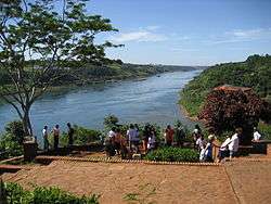
Tourism
The Triple Frontier is an important tourist area, within the touristic subregion of the Región de las Aguas Grandes. Visitors can see the Tancredo Neves bridge, which connects the Argentine city of Puerto Iguazú and its Brazilian neighbor, Foz do Iguaçu. At the convergence of the borders, each of the three bordering countries has erected an obelisk, painted in the national colors of the country in which it is located. All three countries can be seen from each of the obelisks.
The Guarani Aquifer is arguably the biggest reservoir of fresh, potable water in the world - right under Triple Border soil (Brazil, Argentina and Paraguay). The majority (71%) of its 1.2 million square kilometers lies in Brazil.
Terrorist activities
The United States Government cited "clear examples" of Islamic groups in the tri-border region that "finance terrorist activities". Groups like Egypt's al-Gama'a al-Islamiyya, Islamic Jihad, Hezbollah, and Al Qaeda are believed to draw some of their funding from activities in the Triple Frontier.[2][3]
The particular geography of the border region, rampant political corruption and weak judicial system makes it very difficult to monitor organized crime and the illicit activities connected with it.[4] Furthermore, the Paraguayan side of the triple frontier is a desirable haven for terrorist operations since it has no anti-terrorism laws. Thus, financially contributing to terrorist organizations is not punishable by law and terrorist groups operate freely in the region. According to U.S. officials and law enforcement familiar with the region, "Iranian-backed Hezbollah militia have been fostering a well-financed force of Islamist radicals in the region"[5]
A counter-terrorism expert with the Pentagon’s National Security Study Group described the Tri-border as "the most important base for Hezbollah outside Lebanon itself, home to a community of dangerous fanatics that send their money to financially support Hezbollah.”[5] Out of the 25,000 Lebanese Arabs who live in the region, not all of them support terrorism, but many openly acknowledge they send money to Hezbollah and that Shiite mosques have “an obligation to finance it.”[5]
The Paraguayan authorities say they have evidence that money is being sent to organizations with terrorist connections because of the amount of money leaving Paraguay for the Middle East, said Carlos Altemburger, Chief of the Department for the Prevention and Investigation of Terrorism in Paraguay.[6] In response to the situation, Paraguay approved the entry of 400 US soldiers "for joint military exercises, such as programs on fighting urban terrorists, public security and humanitarian assistance," according to the Washington Post.[7] However, in October 2006 Paraguay decided not to renew a defense-cooperation agreement.[8]
In 2005, the governments of the three nations stated they would set up a joint intelligence center in Foz do Iguaçú specifically to monitor the situation.[9]
In popular culture
- The Triple Frontier (or here referenced as the Tri-Border Area) is featured as the backdrop for the NCIS episode "An Eye for an Eye", as NCIS Special Agents Anthony DiNozzo and Caitlin Todd must travel down to this area of southern Paraguay in order to investigate a professor involved in a case in which a pair of blue eyeballs were mailed to a murder victim.
- The Triple Frontier is also featured as the location for The Unit episode "The Kill Zone", where Unit operators must rescue a member of their counterpart team, (Team Charlie) during a hostage situation.
- In the Vince Flynn novel Extreme Measures, a terrorist group funded by al-Qaeda trains and plans to execute terrorist attacks on America while living in the Triple Frontier.
- In the 2006 film Miami Vice, Sonny Crockett and Rico Tubbs first meet with the drug cartel they are trying to infiltrate in the Tri-Border Area.
- Featured in the Human Target episode "The Return of Baptiste", as the location where a kidnapped reporter is held by a crime lord. The accents and geography shown in the episode are inaccurate for this region.
- Included as a major setting of the location for the Sebastian Rotella novel, "Triple Crossing".[10]
See also
References
- ↑ "Paraguay's Ciudad del Este and the New Centers of Gravity". Foreign Military Studies Office. April 2002. Retrieved April 2006. Check date values in:
|access-date=(help) - ↑ Jeffrey Goldberg, "In the Party of God", Part 2 of 2, The New Yorker, 28 October 2002.
- ↑ Frontier in terror spotlight
- ↑ Cristiana Brafman Kittner, "The Role of Safe Havens in Islamist Terrorism", The Journal of Terrorism and Political Violence, September 2007
- 1 2 3 Hezbollah builds a Western base from inside South America’s Tri-border area, Iran-linked militia targets U.S.
- ↑ Frontier in terror spotlight
- ↑ US Marines put a foot in Paraguay, El Clarín, September 9, 2005 (Spanish)
- ↑ Paraguay Hardens U.S. Military Stance, The Washington Post, October 10, 2006
- ↑ Agency to monitor tri-border area, BBC, August 17, 2005.
- ↑ http://www.amazon.com/Triple-Crossing-Novel-Sebastian-Rotella/dp/0316105309
External links
- CNBC Trish-Regan's Diary From a Dangerous Place
- CNBC In Paraguay Piracy Bleeds US Profits Aids Terrorists
- Pulitzer Center on Crisis Reporting Clouds Over Iguaçu (Video)
Coordinates: 25°35′33″S 054°35′35″W / 25.59250°S 54.59306°W