Tropical Storm Cristobal (2002)
| Tropical storm (SSHWS/NWS) | |
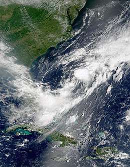 Satellite image of Tropical Storm Cristobal | |
| Formed | August 5, 2002 |
|---|---|
| Dissipated | August 13, 2002 |
| (Extratropical after August 8, 2002) | |
| Highest winds |
1-minute sustained: 50 mph (85 km/h) |
| Lowest pressure | 999 mbar (hPa); 29.5 inHg |
| Fatalities | 3 indirect |
| Damage | Minimal |
| Areas affected | Bermuda, New York |
| Part of the 2002 Atlantic hurricane season | |
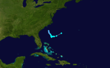
Tropical Storm Cristobal was a relatively weak tropical cyclone that meandered in the western Atlantic Ocean prior to being absorbed into a frontal zone. The third named storm of the 2002 Atlantic hurricane season, Cristobal developed on August 5 near the coast of South Carolina from the same trough that spawned Tropical Storm Bertha. The storm tracked slowly southeastward in the early portion of its duration, and initially remained disorganized. Cristobal attained peak winds of 50 mph (85 km/h), and lost the characteristics of a tropical cyclone on August 8. The remnants brought moderate precipitation to Bermuda, and in combination with a high pressure system the storm caused three drownings on Long Island from rip currents.
Meteorological history
A trough extended from the northern Gulf of Mexico to the western Atlantic Ocean in early August. The trough remained nearly stationary, spawning Tropical Storm Bertha in the Gulf of Mexico and a tropical disturbance off the coast of South Carolina.[1] The weak low pressure area off South Carolina drifted southward, with its associated deep convection increasing in organization on August 4.[2] By 1800 UTC on August 5, the system had acquired sufficient organization to be classified as Tropical Depression Three, while located about 175 miles (280 km/h) east-southeast of Charleston, South Carolina.[1]
Upon becoming a tropical depression, the cyclone maintained outer rainbands and fair outflow. It tracked southeastward around the northeastern periphery of an anticyclone over Florida.[3] By August 6, the convection had diminished as outflow became restricted due to northeasterly wind shear;[4] with a relatively dry environment, most of the convection was confined to the southern semicircle of the depression. Despite the circulation becoming elongated in the southwesterly flow of a southward moving cold front, a Hurricane Hunters flight late on August 6 reported that the depression intensified into Tropical Storm Cristobal about 315 miles (505 km) east of Jacksonville, Florida.[1]
Tropical Storm Cristobal initially continued tracking southeastward, with its circulation reforming closer to the thunderstorms during each increase in convection.[5] On August 7 the storm turned eastward, due to the influence of a large approaching mid to upper-level frontal zone. As the convection organized further, Cristobal intensified somewhat and attained peak winds of 50 mph (85 km/h). On August 8, increased dry air weakened the convection and caused Cristobal to accelerate east-northeastward. The low-level circulation interacted with the approaching frontal zone, and by 0000 UTC on August 9 Tropical Storm Cristobal was absorbed by the cold front about 350 miles (560 km) southeast of Cape Hatteras, North Carolina.[1] The remnants continued northeastward, passing near Newfoundland on August 10 before weakening near Greenland on August 14.[6]
Impact
As a tropical cyclone, Cristobal had minimal effect to any land masses.[1] Its remnants brought unsettled conditions to Bermuda, including a 45 mph (72 km/h) wind gust at the Bermuda International Airport. The combination of moisture from Cristobal and a cold front produced 2.78 inches (71 mm) in a 24‑hour period.[7] The interaction between the remnants of Cristobal and a high pressure system over the Mid-Atlantic States produced rip currents and 4 foot (1.2 m) waves along the south shore of Long Island, New York; three people drowned from the rip currents.[8] Two ships recorded tropical storm force winds in association with the storm; the vessel with the sign WUQL reported sustained winds of 47 mph (76 km/h) from the west-southwest on August 7.[1]
See also
References
- 1 2 3 4 5 6 James Franklin (2002). "Tropical Storm Cristobal Tropical Cyclone Report" (PDF). National Hurricane Center. Retrieved 2015-05-26.
- ↑ Stacy Stewart (2002). "August 4 Tropical Weather Outlook". National Hurricane Center. Retrieved 2008-01-08.
- ↑ Jack Beven (2002). "Tropical Depression Three Discussion One". National Hurricane Center. Retrieved 2008-01-08.
- ↑ Stacy Stewart (2002). "Tropical Depression Three Discussion Two". National Hurricane Center. Retrieved 2008-01-08.
- ↑ Stacy Stewart (2002). "Tropical Storm Cristobal Discussion Seven". National Hurricane Center. Retrieved 2008-01-08.
- ↑ Gary Padgett (2002). "Worldwide Tropical Summary for August 2002". Retrieved 2008-01-08.
- ↑ Bermuda Weather Service (2002). "Bermuda Weather for August 2002". Retrieved 2008-01-08.
- ↑ National Climatic Data Center (2002). "Event Report for New York". Retrieved 2008-01-08.
| Wikimedia Commons has media related to Tropical Storm Cristobal (2002). |
Tropical cyclones of the 2002 Atlantic hurricane season | ||
|---|---|---|
 | ||
| ||