Tropical Storm Matthew (2004)
| Tropical storm (SSHWS/NWS) | |
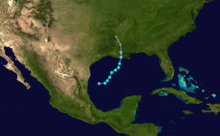
.jpg) Tropical Storm Matthew off the coast of Louisiana | |
| Formed | October 8, 2004 |
|---|---|
| Dissipated | October 11, 2004 (Became extratropical on October 10) |
| Highest winds |
1-minute sustained: 45 mph (75 km/h) |
| Lowest pressure | 997 mbar (hPa); 29.44 inHg |
| Fatalities | None |
| Damage | $305,000 (2004 USD) |
| Areas affected | Louisiana, Mississippi, Alabama, Florida, Arkansas, Missouri, Ohio Valley |
| Part of the 2004 Atlantic hurricane season | |
Tropical Storm Matthew was a weak tropical storm in the 2004 Atlantic hurricane season that made landfall on Louisiana. Matthew was the thirteenth tropical storm of the season and the ninth storm to affect the United States. Matthew formed over the western Gulf of Mexico on October 8 and struck south-central Louisiana two days later. The combination of this storm and an upper cyclone over the southern Plains brought heavy rains to much of the Gulf Coast, with the highest amounts reported lying over 15 inches (381 mm) in northern Louisiana. Damage was minimal, totaling $305,000 (2004 USD), and no casualties were reported.
Meteorological history
A tropical wave moved off the coast of Africa on September 19. The wave moved westward, but was difficult to track due to its proximity to Hurricane Lisa and another large tropical wave. It passed through the Lesser Antilles, and slowly organized as convection increased due to an upper level low. On October 5, it entered the Gulf of Mexico, and developed an area of low pressure two days later. The system continued to organize, and on October 8, after developing a circulation, it developed into Tropical Depression Fourteen while located 205 miles (330 km) to the southeast of Brownsville, Texas.[1]
The depression moved to the east-northeast, and quickly strengthened into Tropical Storm Matthew. Operationally, Matthew fluctuated between tropical depression and tropical storm status, but in post-season analysis, the storm remained a tropical storm. The storm turned to the northeast while moving around the periphery of a high pressure system over Texas, and attained a peak intensity of 45 mph (70 km/h) on October 9. Strong wind shear limited further strengthening, and on October 10, Matthew struck Cocodrie, Louisiana as a minimal tropical storm.[1] It became an Extratropical cyclone, occluding near the time of landfall.[2]
After it merged with the system, the storm moved inland over Arkansas, Tennessee and the Ohio Valley. While moving inland, Matthew spun off another low pressure system that formed over North Carolina on October 13. The low moved off the Mid-Atlantic coast before hitting Massachusetts two days later, and later merged with the original low pressure system of Matthew.[2]
Preparations
Initially, forecasters at the National Hurricane Center predicted that Matthew would take a more eastern track and hit the Florida Panhandle.[3] Because the track shifted westward, the National Hurricane Center issued a Tropical Storm Warning from the Florida/Alabama border to Intracoastal City, Louisiana on the day before landfall.[1]
Impact

Though damage was minor throughout its path, Matthew dropped moderate to heavy rainfall across much of the Gulf Coast, peaking at over 15 inches (381 mm) in portions of Louisiana.
Louisiana
Upon making landfall, Matthew caused a storm surge of up to 5.85 feet (1.8 m) in Frenier, Louisiana. The storm surge and waves resulted in significant beach erosion in Grand Isle. Matthew produced heavy rainfall across its path, totaling to 16.23 inches (410 mm) in Reserve in the southeastern portion of the state.[1] Portions of northwestern Louisiana experienced significant rainfall, including a peak of 18 inches (460 mm) in Haynesville near the Louisiana/Arkansas border.[2] In addition, Matthew spawned one tornado, causing damage to the roof of a trailer in Golden Meadow.[1] The rainfall also caused rivers to crest higher than normal, including the Killian River which peaked at 5.7 feet (1.7 m).[4]
Rainfall and storm surge flooded 20 homes in Terrebonne Parish. In addition, several homes in Lafouche Parish experienced flooding, including two with over two feet of water. Numerous homes in Golden Meadow experienced flooding, as well. The flooding also forced the temporary closing of numerous roads across the state,[4] including portions of U.S. Route 11 and Interstate 10. Flood waters from the storm cracked a water line in LaPlace, leaving nearly 30,000 residents and many businesses without tap water. The problem was expected to take little time to fix, though residents were advised to boil the water before drinking it. Matthew also left 2,500 people without power for a short period of time. The storm's impact also closed several schools, forcing school administrators to reschedule plans for making up school closings caused by Hurricane Ivan one month earlier.[5] In all, Matthew caused no deaths and $255,000 in damage (2004 USD).[6]
Elsewhere
As the storm made landfall, the outer-bands of Matthew brought heavy rains in Florida. The rain was reported as far south as Naples. In Pensacola, 30 mph (48 km/h) gusts were reported, as well rainfall totaling up to 3 to 4 inches (75 to 100 mm).[7] In Alabama, wind gusts peaked at 47 mph (75 km/h) at Dauphin Island. The storm produced light rainfall across the state, totaling to 2.74 inches (70 mm) at Grand Bay. In addition, Matthew produced tides of 1 to 3 feet (.3 to .9 m) above normal, causing minor to major beach erosion. The beach erosion, which typically would have been minor for a weak storm, was greater than expected due to the passage of Hurricane Ivan just weeks before. No major damage was reported in Alabama.[8] In Mississippi, winds gusts peaked at 45 mph (72 km/h) with sustained winds of 39 mph (63 km/h) in Waveland. Storm surge ranged from 2 to 4 feet (.6 to 1.2 m) along much of the coastline, though Waveland reported a peak of 5.13 feet (1.56 m). Rainfall totals were mainly between 2 and 4 inches (50 to 100 mm). Damage in Mississippi totaled to $50,000 (2004 USD).[6]
Matthew produced moderate rainfall on its west side, as well. Portions of Texas and Oklahoma experienced over 5 inches (127 mm) of rain, while southern Arkansas received over 10 inches (255 mm) of rainfall.[2] The rainfall was well-received due to a period of dry weather in the area. Though it slowed harvest activities, it aided pastures.[9]
See also
- Other storms of the same name
- Tropical cyclone
- Timeline of the 2004 Atlantic hurricane season
- List of Florida hurricanes (2000–present)
References
- 1 2 3 4 5 Avila, Lixion (2004). "Tropical Storm Matthew Tropical Cyclone Report" (PDF). National Hurricane Center. Retrieved May 22, 2015.
- 1 2 3 4 Roth, David (2004). "Tropical Storm Matthew - October 6-15, 2004". Hydrometeorological Prediction Center. Retrieved 2010-08-21.
- ↑ Miami Herald (2004). "Tropical Storm Matthew expected to head for Florida". Retrieved 2006-05-22.
- 1 2 National Weather Service (2004). "Post-Tropical Cyclone Report- Tropical Storm Matthew". Archived from the original on January 29, 2006. Retrieved 2006-05-22.
- ↑ Susan Finch & Aesha Rasheed (2004). "Matthew Floods Roads, Homes". The Times Picayune. Archived from the original on January 17, 2006. Retrieved 2006-05-22.
- 1 2 Storm Data and Unusual Weather Phenomena (2004). "October 2004 Summary". Retrieved 2006-05-23.
- ↑ Ed Schessl (2004). "Summer of Storms 2004". Archived from the original on 2006-05-17. Retrieved 2006-05-24.
- ↑ National Weather Service (2004). "Storm Data and Unusual Weather Phenomena (Alabama)" (PDF). Archived from the original (PDF) on August 30, 2006. Retrieved 2006-05-24.
- ↑ National Agriculture Statistics Service (2004). "Weekly Weather and Crop Bulletin (October 3–9)" (PDF). Archived from the original (PDF) on January 14, 2006. Retrieved 2006-05-24.
External links
| Wikimedia Commons has media related to Tropical Storm Matthew (2004). |
Tropical cyclones of the 2004 Atlantic hurricane season | ||
|---|---|---|
 | ||
| ||