Tryfan
| Tryfan | |
|---|---|
 | |
| Highest point | |
| Elevation | 917.5 m (3,010 ft) [1] |
| Prominence | 191 m (627 ft) |
| Parent peak | Glyder Fawr |
| Listing | Marilyn Hewitt, Welsh 3000, Nuttall |
| Naming | |
| Translation | three peaks / tops [2] (Welsh) |
| Pronunciation | Welsh: [ˈtrʌvæn] |
| Geography | |
| Location | Conwy, Wales |
| Parent range | Snowdonia |
| OS grid | SH664593 |
| Topo map | OS Landranger 115 / Explorer OL17 |
Tryfan is a mountain in the Ogwen Valley, Snowdonia, Wales. It forms part of the Glyderau group, and is one of the most famous and recognisable peaks in Britain, having a classic pointed shape with rugged crags. At 917.5 m (3,010 ft) above sea level it is the fifteenth highest mountain in Wales. The name "Tryfan" is derived from its historical Welsh name of "Tri-faen". "Tri" meaning three and "faen" meaning rocks which makes reference to the 3 rocky humps seen on the mountain's summit.[3]
Between the mid-1980s and June 2010, its accepted height was 915 m (3,002 ft). However it was resurveyed using accurate GPS measurements and found to be 2.4 metres (eight feet) higher.[1] Until the 1980s, Ordnance Survey maps gave its height as 917.5 m (3,010 ft), and so the new measurement confirms that the earlier survey was correct.
Tryfan is said to be the final resting-place of Sir Bedivere (Bedwyr) of Arthurian legend.[4]
Routes of ascent
There are many routes of ascent, ranging from easy ridge scrambling, to long mountaineering rock climbs on the east face.
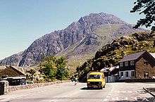
Tryfan is most frequently climbed via its north ridge, which starts close to the A5 road, about 1.5 km east of Idwal Cottage (a youth hostel) or Ogwen Cottage (an outdoor pursuits centre). From here a route leads directly up the ridge, a Grade 1 scramble by the easiest line. The difficulty can be increased considerably if the most direct line is followed throughout; particularly in the upper sections of the ridge. About a third of the way up there is a distinctive rock known as "The Cannon" which points upwards at 45 degrees and is visible from the valley.
Tryfan may also be climbed by the south ridge, also a Grade 1 scramble, which links the mountain (via Bristly Ridge) to Glyder Fach. The route begins at Bwlch Tryfan, the col between Tryfan and Bristly Ridge. The col is reached by a path leading up from Idwal Cottage to the west, passing through Cwm Bochlwyd. This cwm contains Llyn Bochlwyd, sometimes called "Lake Australia" [5] due to the resemblance of its shape to that country.
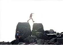
The summit of Tryfan is famous for the twin monoliths of Adam and Eve (Siôn a Siân in Welsh), a pair of rocks some three metres high and separated by 1.2 metres. The rocks are visible from the Ogwen valley, from where they resemble two human figures.
It is traditional for those climbing Tryfan to tackle the spectacular and risky "step" between the two rocks; in doing so one is said to gain the "Freedom of Tryfan". The exposure on one side is quite great and those without a head for heights are advised not to attempt the step. Adam is not easily scaled being high and smooth. There is a foothold on Eve which allows the climber to scramble to the top. Two prominent pillar-like boulders are visible on the skyline midway through the approach to the summit via the South ridge. As these can be mistaken for Adam and Eve from a distance, they have become known as Cain and Abel, continuing the biblical theme.
Milestone Buttress
Milestone Buttress at the base of Tryfan is a popular location for climbing. The Buttress is about 10 minutes walk from roadside laybys. The most popular route is known as the direct route: there are often queues of people waiting to climb it. It is 75 m long, and graded Very Difficult. The route was first climbed by G. Barlow and H. Priestly-Smith in 1910.
There is also a popular Grade 3 scramble incorporating the Milestone Buttress. This route is commonly used as an alternative approach to the North Ridge, as is the nearby slabby wedge of Tryfan Bach, on the other side of the mountain.

References
- 1 2 "Survey adds 8ft to Tryfan mountain's height". BBC News. June 24, 2010. Retrieved April 27, 2011.
- ↑ Terry Batt (1994). Place-names in the 3000ft Mountains of Wales. Gwasg Carreg Gwalch. ISBN 978-0-86381-282-8.
- ↑ "Tryfan". National Trust. Retrieved 2016-09-16.
- ↑ Topham, Simon. "Llyn Ogwen". Mysterious Britain and Ireland. Retrieved 16 April 2016.
- ↑ Snowdonia Guide website
Bibliography
- Williams, Paul (1990). Rock climbing in Snowdonia. Constable. ISBN 0-09-468410-3.
- Ashton, Steve (1992). Scrambles in Snowdonia. Cicerone. ISBN 1-85284-088-9.
External links
- Computer generated summit panoramas North South index
- Climber's guide to Tryfan
- www.geograph.co.uk : photos of Tryfan and surrounding area
Coordinates: 53°06′54″N 3°59′51″W / 53.11494°N 3.99753°W