Tupã, São Paulo
| Tupã | |
|---|---|
| Municipality | |
|
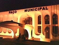
City Hall at night | |
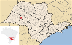 Location in São Paulo state | |
 Tupã Location in Brazil | |
| Coordinates: 21°56′5″S 50°30′49″W / 21.93472°S 50.51361°WCoordinates: 21°56′5″S 50°30′49″W / 21.93472°S 50.51361°W | |
| Country |
|
| Region | Southeast Region |
| State | São Paulo |
| Area | |
| • Total | 628 km2 (242 sq mi) |
| Population (2015) | |
| • Total | 65,651 |
| • Density | 100/km2 (270/sq mi) |
| Time zone | BRT/BRST (UTC-3/-2) |
Tupã is a municipality in the state of São Paulo in Brazil. The population is 65,651 (2015 est.) in an area of 628 km².[1] The city is located in the Alta Paulista Region and it is located 530 km (329.32 sq mi) from capital São Paulo. It was founded on October 12, 1929 by Luiz de Souza Leão a business man that chose the region that were tropical forest. The city is located between 2 rivers: Aguapeí River and Rio do Peixe.
The name of the city is a Guaraní word meaning "God".
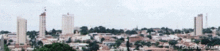
Tupã Downtown
References
- ↑ "IBGE - Instituto Brasileiro de Geografia e Estat�stica". Retrieved 9 August 2016. replacement character in
|title=at position 49 (help)
External links
- (Portuguese) Tupã City Hall Website
- (Portuguese) Tourism Information (provided by the City Hall)
- (Portuguese) Satellite image of Tupã on Google Maps
This article is issued from Wikipedia - version of the 11/12/2016. The text is available under the Creative Commons Attribution/Share Alike but additional terms may apply for the media files.