U.S. Route 40 in Pennsylvania
| ||||||||||
|---|---|---|---|---|---|---|---|---|---|---|
| National Road | ||||||||||
 | ||||||||||
| Route information | ||||||||||
| Maintained by PennDOT | ||||||||||
| Length: | 82.50 mi[1] (132.77 km) | |||||||||
| Major junctions | ||||||||||
| West end: |
| |||||||||
|
| ||||||||||
| East end: |
| |||||||||
| Location | ||||||||||
| Counties: | Washington, Fayette, Somerset | |||||||||
| Highway system | ||||||||||
| ||||||||||
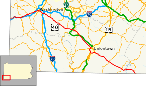
U.S. Route 40 enters Pennsylvania at West Alexander. It closely parallels I-70 from West Virginia until it reaches Washington where it follows Jefferson Avenue and Maiden Street. In Washington, US 40 passes to the south of Washington & Jefferson College. Following Maiden Street out of town, the road turns southeast toward the town of California. A short limited access highway in California and West Brownsville provides an approach to the Lane Bane Bridge across the Monongahela River. From here, the road continues southeast to Uniontown.
US 40 bypasses Uniontown along a limited access highway that also carries US 119. An old alignment through Uniontown is signed as "Business US 40." Southeast of Uniontown, travellers pass the Fort Necessity National Battlefield. It follows Braddock Road southeast of Uniontown, crossing the Youghiogheny River Lake on a bridge completed in 2006. US 40 leaves Pennsylvania at Addison.
Route description
Washington County

U.S. Route 40 enters Pennsylvania in rural western Washington County near West Alexander. It travels to the west-northwest paralleling I-70 through Claysville on to Washington. While in Washington, the largest city on U.S. 40 in Pennsylvania, it is named Chestnut St. Exit 15 on I-70/I-79 is signed for Chestnut St. Route 40 leaves Chestnut St. and joins PA 18 becoming Jefferson Ave. After two blocks of concurrency with PA 18, it leaves PA 18 and joins US 19. US 40/US 19 then leaves Washington as Maiden St. US 19 leaves Route 40 in Laboratory before it intersects I-79 again at exit 33. Now heading east-southeast, US 40 makes its way toward Brownsville. Route 40 passes through Scenery Hill and Beallsville before reaching PA 43/PA 88 at a full cloverleaf interchange in Centerville. US 40 then crosses the Monongahela River via the Lane Bane Bridge leaving Washington County after spending nearly 40 miles (64 km) in the county.[2]
Fayette and Somerset Counties
US 40 enters Fayette County as Market St. in Brownsville. After leaving Brownsville, Route 40 heads to the southeast toward Uniontown. The highway enters Uniontown as Main St. in front of the Uniontown Mall. When it reaches US 119 it merges with it becoming a bypass of Uniontown. However, US 40 Business passes through downtown Uniontown as the one-way pair of Main St. and Fayette St. US 40 travels around the south of Uniontown and meets again with US 40 Business in Hopwood after leaving US 119. Route 40 then begins a steep ascent up the Appalachian Mountains. US 40 becomes a treacherous mountain highway for the next 10 miles (16 km) featuring steep descents and sharp curves. After passing through Chalk Hill, the National Road passes Fort Necessity National Battlefield and continues to Farmington. On the east side of Farmington, the highway passes Nemacolin Woodlands Resort. The National Pike then continues southeast toward the Maryland border after crossing the Youghiogheny River and entering Somerset County. Before leaving Pennsylvania, Route 40 passes through Addison. U.S. Route 40 spends 36.5 miles (58.7 km) in Fayette County and 6.1 miles (9.8 km) in Somerset County, passing through its southwestern corner. It enters Maryland in Garrett County.[3]
History
1789 to 1860
Envisioned by George Washington, US 40, or the National Road was built to connect the East and West. Needed by farmers and emigrants alike, the National Road would provide a stable route for trade through the Allegheny Mountains.[4] The National Road was preceded by buffalo trails, Native American footpaths, and the Nemacolin Trail. After the Revolutionary War, and an increase in migration westward, the newly formed national government realized that communication with the west would be difficult with the Appalachian Mountains separating the east coast from the western frontier. Therefore, the highway was put into Ohio's statehood bill by Albert Gallatin in 1802.[5]
In 1806, Thomas Jefferson authorized the construction of the Cumberland Road—the first federally funded highway in American history. Construction began in 1811 in Cumberland, Maryland and was completed to Wheeling, Virginia (present-day West Virginia) in 1820. In the 1830s, possession of the highway was turned over to the states through which it passes, which allowed states to collect tolls. The Commonwealth of Pennsylvania constructed six tollhouses along its 90–mile–segment of the highway. Two of these still stand: the Petersburg Tollhouse in Addison and the Searights Tollhouse in Fayette County. The Petersburg Tollhouse is the last remaining tollhouse constructed of native-cut stone in the United States.[6][7] Mile markers were also placed along the route. Made of cast-iron, these obelisk markers were placed every one mile and noted the distance to Cumberland and Wheeling and nearby towns. All of these markers are present today, though not all are the originals. Also in the 1830s, the Pony Express utilized the National Road. The 1840s marked the peak of the National Road. Used by many important figures including presidents, future presidents, and other notables, local businesses saw booming success along the road. This time period gave the National Road its nickname of the nation's "Main Street". The navigation of the Monongahela River after the construction of several locks and dams gave the National Road access to Pittsburgh via Brownsville. The Baltimore & Ohio Railroad also arrived in Cumberland in the 1840s. This allowed travel from the east coast to Cumberland via train, from Cumberland to Brownsville via stage coach, and then from Brownsville to Pittsburgh via steamboat. In the 1850s, railroads made it to the west causing the demise of the National Road.[5]
1860 to present
In the 1860s, the National Road became insignificant due to the use of the railroads. Many businesses along the route became private homes and the stage coach line went out of business. States relinquished responsibility of the highway to the counties so little or no maintenance was performed on the road. The 1880s brought a small revival to the National Road with the formation of the Good Roads Movement. The invention of the automobile would truly revitalize the highway. Touring along the National Road was popular and many of the businesses returned to offer services to this new type of consumer. The Post Office Appropriation Act of 1912 and the Rural Road Act of 1916 provided funds to rebuild the National Road, and World War I and the overburdened railroads made national highways a priority in the early twentieth century. In 1921, the National Road became U.S. Route 40 after the National Highway Act. The Pennsylvania Route 11 designation was also given to the National Road through Pennsylvania, eventually becoming Pennsylvania Route 81 before the road became solely US 40. The road became very popular again in the 1940s, but this only lasted until the 1950s when the Interstate Highway System was put into place. Today, US 40 has been replaced significantly by Interstate 70 and Interstate 68. US 40 is still used as a local road and scenic route in Pennsylvania, however. US 40 in Pennsylvania has been designated an All American Road (June 13, 2002), a Pennsylvania State Scenic Byway (July 11, 1996), and the Pennsylvania Heritage Corridor (May, 1994).[4][5]
Major intersections
| County | Location | mi[1] | km | Exit | Destinations | Notes |
|---|---|---|---|---|---|---|
| Washington | Donegal Township | 0.0 | 0.0 | US 40 enters Pennsylvania from West Virginia. | ||
| Claysville | 6.3 | 10.1 | Western terminus of concurrency. | |||
| 6.5 | 10.5 | Eastern terminus of concurrency. | ||||
| Buffalo Township | 10.3 | 16.6 | ||||
| North Franklin Township | 14.7 | 23.7 | Interchange, I-79 exit 15. | |||
| Washington | 16.2 | 26.1 | Western terminus of concurrency. | |||
| 16.4 | 26.4 | Western terminus of PA 136. | ||||
| 16.8 | 27.0 | Eastern terminus of concurrency. | ||||
| 16.9 | 27.2 | Western terminus of concurrency. | ||||
| South Strabane Township | 18.9 | 30.4 | Eastern terminus of concurrency. | |||
| Amwell Township | 19.4 | 31.2 | Interchange, I-79 exit 33. | |||
| North Bethlehem Township | 23.5 | 37.8 | Southern terminus of PA 519. | |||
| 27.3 | 43.9 | Southern terminus of PA 917. | ||||
| Centerville | 34.9 | 56.2 | Southern terminus of PA 481. | |||
| West Brownsville | West end of freeway | |||||
| 37.7 | 60.7 | A | PA 43 exit 30. Western terminus of concurrency with PA 88. | |||
| 37.7 | 60.7 | B | PA 43 exit 30. | |||
| 39.3 | 63.2 | Eastern terminus of concurrency with PA 88. | ||||
| Monongahela River | Lane Bane Bridge | |||||
| Fayette | Brownsville | Brownsville | Access via Market Street | |||
| East end of freeway | ||||||
| Brownsville Township | Northern terminus of PA 166. | |||||
| Redstone Township | Interchange, Alternative route to Uniontown. | |||||
| Eastern terminus of US 40 Bus. | ||||||
| Uniontown | West end of freeway | |||||
| 51.3 | 82.6 | Western terminus of concurrency with US 119, western terminus of US 40 BUS. | ||||
| South Union Township | 52.0 | 83.7 | ||||
| Walnut Hill Road | ||||||
| 54.2 | 87.2 | No westbound exit, eastern terminus of concurrency. | ||||
| Westbound exit | ||||||
| 56.9 | 91.6 | Eastern terminus of US 40 BUS. | ||||
| East end of freeway | ||||||
| Wharton Township | 65.7 | 105.7 | Western terminus of concurrency. | |||
| 65.8 | 105.9 | Eastern terminus of concurrency. | ||||
| Henry Clay Township | 73.3 | 118.0 | Western terminus of concurrency. | |||
| 73.5 | 118.3 | Eastern terminus of concurrency. | ||||
| Somerset | Addison | 80.5 | 129.6 | Southern terminus of PA 523. | ||
| Addison Township | 82.3 | 132.4 | US 40 leaves Pennsylvania and enters Maryland. | |||
1.000 mi = 1.609 km; 1.000 km = 0.621 mi
| ||||||
See also
 U.S. Roads portal
 Pennsylvania portal
References
- 1 2 Google (2008-10-13). "US 40 in Pennsylvania" (Map). Google Maps. Google. Retrieved 2008-10-13.
- ↑ Google (2008-10-13). "US 40 in Washington County" (Map). Google Maps. Google. Retrieved 2008-10-13.
- ↑ Google (2008-10-13). "US 40 in Fayette and Somerset Counties" (Map). Google Maps. Google. Retrieved 2008-10-13.
- 1 2 "Historic National Road -- Pennsylvania Overview". National Scenic Byways Program. Retrieved 2008-10-24.
- 1 2 3 "Timeline". Historic National Road: America's Road to Revolution. National Road PA. Retrieved 2015-12-04.
- ↑ Joseph S. Mendinghall and S. Sydney Bradford (May 8, 1975). "National Register of Historic Places Inventory-Nomination: Searights Tollhouse, National Road" (pdf). National Park Service. and Accompanying 3 photos, exterior, from 1975. (32 KB)
- ↑ "Petersburg Tollhouse: Addison, PA". Petersburg Tollhouse: Addison, PA. Daughters of the American Revolution. Retrieved 2015-12-04.
| Previous state: West Virginia |
Pennsylvania | Next state: Maryland |