Union Level, Virginia
| Union Level | |
|---|---|
| CDP | |
 Union Level Location within the Commonwealth of Virginia | |
| Coordinates: 36°42′26″N 78°13′55″W / 36.70722°N 78.23194°WCoordinates: 36°42′26″N 78°13′55″W / 36.70722°N 78.23194°W | |
| Country | United States |
| State | Virginia |
| County | Mecklenburg |
| Population (2010) | |
| • Total | 188 |
| Time zone | Eastern (EST) (UTC-5) |
| • Summer (DST) | EDT (UTC-4) |
| ZIP codes | 23970 |
| FIPS code | 51-80016 |
| GNIS feature ID | 2584931 |
Union Level is a census-designated place in Mecklenburg County, Virginia. The population as of the 2010 Census was 188.[1]
References
- ↑ Virginia Trend Report 2: State and Complete Places (Sub-state 2010 Census Data). Missouri Census Data Center. Accessed 2011-06-08.
Municipalities and communities of Mecklenburg County, Virginia, United States | ||
|---|---|---|
| Towns | 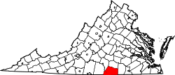 | |
| CDPs | ||
| Unincorporated communities | ||
| Footnotes | ‡This populated place also has portions in an adjacent county or counties | |
This article is issued from Wikipedia - version of the 9/4/2016. The text is available under the Creative Commons Attribution/Share Alike but additional terms may apply for the media files.