Unwin's Special Survey
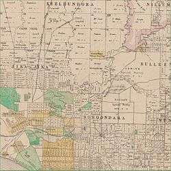
Portion of 1866 map of County of Bourke showing Elgar's and Unwin's Special Survey
In 1841, Frederic Wright Unwin, a Sydney solicitor, purchased 5,120 acres or eight square miles of land approximately 10 km north-east of Melbourne, Victoria, Australia. The land was purchased from the Crown for one pound an acre under the terms of the short-lived Special Survey regulations.[1][2][3]
Unwin's Special Survey covered the area now bounded by the Yarra River (west), Koonung Creek (south), Church Rd (east) and Templestowe Road/Foote St/Reynolds Rd (north).[4] It includes all of the Melbourne suburb of Bulleen, most of Templestowe Lower and Doncaster and the parts of Templestowe
References
- ↑ Colonial Secretaries Office, Sydney (June 8, 1841), "Selections of Special Surveys", New South Wales Government Gazette (Number 45): 784–785, retrieved 2010-09-19
- ↑ Blainey, Geoffrey (1980). A History of Camberwell (Revised ed.). Melbourne: Lothian. ISBN 0-85091-124-9.
- ↑ Lay, Maxwell (2003), Melbourne Miles: The Story of Melbourne's Roads, Melbourne: Australian Scholarly Publishing, ISBN 1-74097-019-5
- ↑ Victoria. Dept. of Crown Lands and Survey (1906). Bulleen, Counties of Evelyn and Bourke, Map RM 2741/244. Parish maps of Victoria.
This article is issued from Wikipedia - version of the 8/27/2015. The text is available under the Creative Commons Attribution/Share Alike but additional terms may apply for the media files.