Utica and Reid Avenues Line
| B46 / B46 Select Bus Service | |||||||||||||||||||||||||||||||||||||||||||||||||||||||||||||||||||||||||||||||||||||||||||||||||||||||||||||||||||||||||||||||||||||||||||||||||||||||||||||||||||||||||||||||||||||||||||||||||||||||||||||||||||||||||||||||||||||||||||||||||||||||||||||||||||||||||||||||||||||||||||||||||||||||||||||||||||||||||||||||||||||||||||||||||||||||||||||||||||||||||||||||||||||||||||||||||||||||||||||||||||||||||||||||||||||||||||||||||||||||||||||||||||||||||||||||||||||||||||||||||||||||||||||||||||||||||||||||||||||||||||||||||||||||||||||||||||||||||||||||||||||||||||||||||||||||||||||||||||||||||||||||||||||||||||||||||||||||||||||||||||||||||||||||||||
|---|---|---|---|---|---|---|---|---|---|---|---|---|---|---|---|---|---|---|---|---|---|---|---|---|---|---|---|---|---|---|---|---|---|---|---|---|---|---|---|---|---|---|---|---|---|---|---|---|---|---|---|---|---|---|---|---|---|---|---|---|---|---|---|---|---|---|---|---|---|---|---|---|---|---|---|---|---|---|---|---|---|---|---|---|---|---|---|---|---|---|---|---|---|---|---|---|---|---|---|---|---|---|---|---|---|---|---|---|---|---|---|---|---|---|---|---|---|---|---|---|---|---|---|---|---|---|---|---|---|---|---|---|---|---|---|---|---|---|---|---|---|---|---|---|---|---|---|---|---|---|---|---|---|---|---|---|---|---|---|---|---|---|---|---|---|---|---|---|---|---|---|---|---|---|---|---|---|---|---|---|---|---|---|---|---|---|---|---|---|---|---|---|---|---|---|---|---|---|---|---|---|---|---|---|---|---|---|---|---|---|---|---|---|---|---|---|---|---|---|---|---|---|---|---|---|---|---|---|---|---|---|---|---|---|---|---|---|---|---|---|---|---|---|---|---|---|---|---|---|---|---|---|---|---|---|---|---|---|---|---|---|---|---|---|---|---|---|---|---|---|---|---|---|---|---|---|---|---|---|---|---|---|---|---|---|---|---|---|---|---|---|---|---|---|---|---|---|---|---|---|---|---|---|---|---|---|---|---|---|---|---|---|---|---|---|---|---|---|---|---|---|---|---|---|---|---|---|---|---|---|---|---|---|---|---|---|---|---|---|---|---|---|---|---|---|---|---|---|---|---|---|---|---|---|---|---|---|---|---|---|---|---|---|---|---|---|---|---|---|---|---|---|---|---|---|---|---|---|---|---|---|---|---|---|---|---|---|---|---|---|---|---|---|---|---|---|---|---|---|---|---|---|---|---|---|---|---|---|---|---|---|---|---|---|---|---|---|---|---|---|---|---|---|---|---|---|---|---|---|---|---|---|---|---|---|---|---|---|---|---|---|---|---|---|---|---|---|---|---|---|---|---|---|---|---|---|---|---|---|---|---|---|---|---|---|---|---|---|---|---|---|---|---|---|---|---|---|---|---|---|---|---|---|---|---|---|---|---|---|---|---|---|---|---|---|---|---|---|---|---|---|---|---|---|---|---|---|---|---|---|---|---|---|---|---|---|---|---|---|---|---|---|---|---|---|---|---|---|---|---|---|---|---|---|---|---|---|---|---|---|---|---|---|---|---|---|---|---|---|---|---|---|---|---|---|---|---|---|---|---|---|---|---|---|---|---|---|---|---|---|---|---|---|---|---|---|---|---|---|---|---|---|---|---|---|---|---|---|---|---|---|---|---|---|---|---|---|---|---|---|---|---|---|---|---|---|---|---|---|---|---|---|---|---|---|---|---|---|---|---|---|---|---|---|---|---|---|---|---|---|---|---|---|---|---|---|---|---|---|---|---|---|---|---|---|---|---|---|---|---|---|---|---|---|---|---|---|---|---|
| Utica Avenue Line | |||||||||||||||||||||||||||||||||||||||||||||||||||||||||||||||||||||||||||||||||||||||||||||||||||||||||||||||||||||||||||||||||||||||||||||||||||||||||||||||||||||||||||||||||||||||||||||||||||||||||||||||||||||||||||||||||||||||||||||||||||||||||||||||||||||||||||||||||||||||||||||||||||||||||||||||||||||||||||||||||||||||||||||||||||||||||||||||||||||||||||||||||||||||||||||||||||||||||||||||||||||||||||||||||||||||||||||||||||||||||||||||||||||||||||||||||||||||||||||||||||||||||||||||||||||||||||||||||||||||||||||||||||||||||||||||||||||||||||||||||||||||||||||||||||||||||||||||||||||||||||||||||||||||||||||||||||||||||||||||||||||||||||||||||||
|
| |||||||||||||||||||||||||||||||||||||||||||||||||||||||||||||||||||||||||||||||||||||||||||||||||||||||||||||||||||||||||||||||||||||||||||||||||||||||||||||||||||||||||||||||||||||||||||||||||||||||||||||||||||||||||||||||||||||||||||||||||||||||||||||||||||||||||||||||||||||||||||||||||||||||||||||||||||||||||||||||||||||||||||||||||||||||||||||||||||||||||||||||||||||||||||||||||||||||||||||||||||||||||||||||||||||||||||||||||||||||||||||||||||||||||||||||||||||||||||||||||||||||||||||||||||||||||||||||||||||||||||||||||||||||||||||||||||||||||||||||||||||||||||||||||||||||||||||||||||||||||||||||||||||||||||||||||||||||||||||||||||||||||||||||||||
|
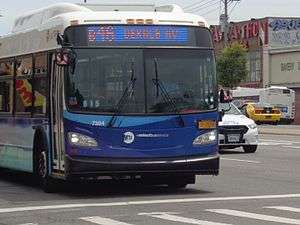
A B46 SBS during the debut of SBS service in 2016. | |||||||||||||||||||||||||||||||||||||||||||||||||||||||||||||||||||||||||||||||||||||||||||||||||||||||||||||||||||||||||||||||||||||||||||||||||||||||||||||||||||||||||||||||||||||||||||||||||||||||||||||||||||||||||||||||||||||||||||||||||||||||||||||||||||||||||||||||||||||||||||||||||||||||||||||||||||||||||||||||||||||||||||||||||||||||||||||||||||||||||||||||||||||||||||||||||||||||||||||||||||||||||||||||||||||||||||||||||||||||||||||||||||||||||||||||||||||||||||||||||||||||||||||||||||||||||||||||||||||||||||||||||||||||||||||||||||||||||||||||||||||||||||||||||||||||||||||||||||||||||||||||||||||||||||||||||||||||||||||||||||||||||||||||||||
| Overview | |||||||||||||||||||||||||||||||||||||||||||||||||||||||||||||||||||||||||||||||||||||||||||||||||||||||||||||||||||||||||||||||||||||||||||||||||||||||||||||||||||||||||||||||||||||||||||||||||||||||||||||||||||||||||||||||||||||||||||||||||||||||||||||||||||||||||||||||||||||||||||||||||||||||||||||||||||||||||||||||||||||||||||||||||||||||||||||||||||||||||||||||||||||||||||||||||||||||||||||||||||||||||||||||||||||||||||||||||||||||||||||||||||||||||||||||||||||||||||||||||||||||||||||||||||||||||||||||||||||||||||||||||||||||||||||||||||||||||||||||||||||||||||||||||||||||||||||||||||||||||||||||||||||||||||||||||||||||||||||||||||||||||||||||||||
| System | MTA Regional Bus Operations | ||||||||||||||||||||||||||||||||||||||||||||||||||||||||||||||||||||||||||||||||||||||||||||||||||||||||||||||||||||||||||||||||||||||||||||||||||||||||||||||||||||||||||||||||||||||||||||||||||||||||||||||||||||||||||||||||||||||||||||||||||||||||||||||||||||||||||||||||||||||||||||||||||||||||||||||||||||||||||||||||||||||||||||||||||||||||||||||||||||||||||||||||||||||||||||||||||||||||||||||||||||||||||||||||||||||||||||||||||||||||||||||||||||||||||||||||||||||||||||||||||||||||||||||||||||||||||||||||||||||||||||||||||||||||||||||||||||||||||||||||||||||||||||||||||||||||||||||||||||||||||||||||||||||||||||||||||||||||||||||||||||||||||||||||||
| Operator | New York City Transit Authority | ||||||||||||||||||||||||||||||||||||||||||||||||||||||||||||||||||||||||||||||||||||||||||||||||||||||||||||||||||||||||||||||||||||||||||||||||||||||||||||||||||||||||||||||||||||||||||||||||||||||||||||||||||||||||||||||||||||||||||||||||||||||||||||||||||||||||||||||||||||||||||||||||||||||||||||||||||||||||||||||||||||||||||||||||||||||||||||||||||||||||||||||||||||||||||||||||||||||||||||||||||||||||||||||||||||||||||||||||||||||||||||||||||||||||||||||||||||||||||||||||||||||||||||||||||||||||||||||||||||||||||||||||||||||||||||||||||||||||||||||||||||||||||||||||||||||||||||||||||||||||||||||||||||||||||||||||||||||||||||||||||||||||||||||||||
| Garage | Flatbush Depot | ||||||||||||||||||||||||||||||||||||||||||||||||||||||||||||||||||||||||||||||||||||||||||||||||||||||||||||||||||||||||||||||||||||||||||||||||||||||||||||||||||||||||||||||||||||||||||||||||||||||||||||||||||||||||||||||||||||||||||||||||||||||||||||||||||||||||||||||||||||||||||||||||||||||||||||||||||||||||||||||||||||||||||||||||||||||||||||||||||||||||||||||||||||||||||||||||||||||||||||||||||||||||||||||||||||||||||||||||||||||||||||||||||||||||||||||||||||||||||||||||||||||||||||||||||||||||||||||||||||||||||||||||||||||||||||||||||||||||||||||||||||||||||||||||||||||||||||||||||||||||||||||||||||||||||||||||||||||||||||||||||||||||||||||||||
| Vehicle |
B46: B46 SBS:
| ||||||||||||||||||||||||||||||||||||||||||||||||||||||||||||||||||||||||||||||||||||||||||||||||||||||||||||||||||||||||||||||||||||||||||||||||||||||||||||||||||||||||||||||||||||||||||||||||||||||||||||||||||||||||||||||||||||||||||||||||||||||||||||||||||||||||||||||||||||||||||||||||||||||||||||||||||||||||||||||||||||||||||||||||||||||||||||||||||||||||||||||||||||||||||||||||||||||||||||||||||||||||||||||||||||||||||||||||||||||||||||||||||||||||||||||||||||||||||||||||||||||||||||||||||||||||||||||||||||||||||||||||||||||||||||||||||||||||||||||||||||||||||||||||||||||||||||||||||||||||||||||||||||||||||||||||||||||||||||||||||||||||||||||||||
| Livery | B46 SBS: Select Bus Service | ||||||||||||||||||||||||||||||||||||||||||||||||||||||||||||||||||||||||||||||||||||||||||||||||||||||||||||||||||||||||||||||||||||||||||||||||||||||||||||||||||||||||||||||||||||||||||||||||||||||||||||||||||||||||||||||||||||||||||||||||||||||||||||||||||||||||||||||||||||||||||||||||||||||||||||||||||||||||||||||||||||||||||||||||||||||||||||||||||||||||||||||||||||||||||||||||||||||||||||||||||||||||||||||||||||||||||||||||||||||||||||||||||||||||||||||||||||||||||||||||||||||||||||||||||||||||||||||||||||||||||||||||||||||||||||||||||||||||||||||||||||||||||||||||||||||||||||||||||||||||||||||||||||||||||||||||||||||||||||||||||||||||||||||||||
| Began service |
1800s (trolley line) March 18, 1951 (bus service) 1991 (Limited Stop service) July 3, 2016 (B46 SBS)[1] | ||||||||||||||||||||||||||||||||||||||||||||||||||||||||||||||||||||||||||||||||||||||||||||||||||||||||||||||||||||||||||||||||||||||||||||||||||||||||||||||||||||||||||||||||||||||||||||||||||||||||||||||||||||||||||||||||||||||||||||||||||||||||||||||||||||||||||||||||||||||||||||||||||||||||||||||||||||||||||||||||||||||||||||||||||||||||||||||||||||||||||||||||||||||||||||||||||||||||||||||||||||||||||||||||||||||||||||||||||||||||||||||||||||||||||||||||||||||||||||||||||||||||||||||||||||||||||||||||||||||||||||||||||||||||||||||||||||||||||||||||||||||||||||||||||||||||||||||||||||||||||||||||||||||||||||||||||||||||||||||||||||||||||||||||||
| Route | |||||||||||||||||||||||||||||||||||||||||||||||||||||||||||||||||||||||||||||||||||||||||||||||||||||||||||||||||||||||||||||||||||||||||||||||||||||||||||||||||||||||||||||||||||||||||||||||||||||||||||||||||||||||||||||||||||||||||||||||||||||||||||||||||||||||||||||||||||||||||||||||||||||||||||||||||||||||||||||||||||||||||||||||||||||||||||||||||||||||||||||||||||||||||||||||||||||||||||||||||||||||||||||||||||||||||||||||||||||||||||||||||||||||||||||||||||||||||||||||||||||||||||||||||||||||||||||||||||||||||||||||||||||||||||||||||||||||||||||||||||||||||||||||||||||||||||||||||||||||||||||||||||||||||||||||||||||||||||||||||||||||||||||||||||
| Locale | Brooklyn | ||||||||||||||||||||||||||||||||||||||||||||||||||||||||||||||||||||||||||||||||||||||||||||||||||||||||||||||||||||||||||||||||||||||||||||||||||||||||||||||||||||||||||||||||||||||||||||||||||||||||||||||||||||||||||||||||||||||||||||||||||||||||||||||||||||||||||||||||||||||||||||||||||||||||||||||||||||||||||||||||||||||||||||||||||||||||||||||||||||||||||||||||||||||||||||||||||||||||||||||||||||||||||||||||||||||||||||||||||||||||||||||||||||||||||||||||||||||||||||||||||||||||||||||||||||||||||||||||||||||||||||||||||||||||||||||||||||||||||||||||||||||||||||||||||||||||||||||||||||||||||||||||||||||||||||||||||||||||||||||||||||||||||||||||||
| Start |
Williamsburg Bridge Plaza Bus Terminal (full route; local service only) Bedford–Stuyvesant – DeKalb Avenue / Kosciuszko Street station (SBS terminus; short runs) Crown Heights – Eastern Parkway / Utica Avenue station (rush hour short runs) | ||||||||||||||||||||||||||||||||||||||||||||||||||||||||||||||||||||||||||||||||||||||||||||||||||||||||||||||||||||||||||||||||||||||||||||||||||||||||||||||||||||||||||||||||||||||||||||||||||||||||||||||||||||||||||||||||||||||||||||||||||||||||||||||||||||||||||||||||||||||||||||||||||||||||||||||||||||||||||||||||||||||||||||||||||||||||||||||||||||||||||||||||||||||||||||||||||||||||||||||||||||||||||||||||||||||||||||||||||||||||||||||||||||||||||||||||||||||||||||||||||||||||||||||||||||||||||||||||||||||||||||||||||||||||||||||||||||||||||||||||||||||||||||||||||||||||||||||||||||||||||||||||||||||||||||||||||||||||||||||||||||||||||||||||||
| Via | Broadway, Malcolm X Boulevard, Utica Avenue | ||||||||||||||||||||||||||||||||||||||||||||||||||||||||||||||||||||||||||||||||||||||||||||||||||||||||||||||||||||||||||||||||||||||||||||||||||||||||||||||||||||||||||||||||||||||||||||||||||||||||||||||||||||||||||||||||||||||||||||||||||||||||||||||||||||||||||||||||||||||||||||||||||||||||||||||||||||||||||||||||||||||||||||||||||||||||||||||||||||||||||||||||||||||||||||||||||||||||||||||||||||||||||||||||||||||||||||||||||||||||||||||||||||||||||||||||||||||||||||||||||||||||||||||||||||||||||||||||||||||||||||||||||||||||||||||||||||||||||||||||||||||||||||||||||||||||||||||||||||||||||||||||||||||||||||||||||||||||||||||||||||||||||||||||||
| End |
Flatlands – Avenue H and Utica Avenue (short runs) Mill Basin / Marine Park – Kings Plaza / Flatbush Avenue & Avenue U (full route) | ||||||||||||||||||||||||||||||||||||||||||||||||||||||||||||||||||||||||||||||||||||||||||||||||||||||||||||||||||||||||||||||||||||||||||||||||||||||||||||||||||||||||||||||||||||||||||||||||||||||||||||||||||||||||||||||||||||||||||||||||||||||||||||||||||||||||||||||||||||||||||||||||||||||||||||||||||||||||||||||||||||||||||||||||||||||||||||||||||||||||||||||||||||||||||||||||||||||||||||||||||||||||||||||||||||||||||||||||||||||||||||||||||||||||||||||||||||||||||||||||||||||||||||||||||||||||||||||||||||||||||||||||||||||||||||||||||||||||||||||||||||||||||||||||||||||||||||||||||||||||||||||||||||||||||||||||||||||||||||||||||||||||||||||||||
| Length |
7.17 miles (11.54 km) (trolley)[2] 7.9 miles (12.7 km) (bus route)[1][3][4] | ||||||||||||||||||||||||||||||||||||||||||||||||||||||||||||||||||||||||||||||||||||||||||||||||||||||||||||||||||||||||||||||||||||||||||||||||||||||||||||||||||||||||||||||||||||||||||||||||||||||||||||||||||||||||||||||||||||||||||||||||||||||||||||||||||||||||||||||||||||||||||||||||||||||||||||||||||||||||||||||||||||||||||||||||||||||||||||||||||||||||||||||||||||||||||||||||||||||||||||||||||||||||||||||||||||||||||||||||||||||||||||||||||||||||||||||||||||||||||||||||||||||||||||||||||||||||||||||||||||||||||||||||||||||||||||||||||||||||||||||||||||||||||||||||||||||||||||||||||||||||||||||||||||||||||||||||||||||||||||||||||||||||||||||||||
| Service | |||||||||||||||||||||||||||||||||||||||||||||||||||||||||||||||||||||||||||||||||||||||||||||||||||||||||||||||||||||||||||||||||||||||||||||||||||||||||||||||||||||||||||||||||||||||||||||||||||||||||||||||||||||||||||||||||||||||||||||||||||||||||||||||||||||||||||||||||||||||||||||||||||||||||||||||||||||||||||||||||||||||||||||||||||||||||||||||||||||||||||||||||||||||||||||||||||||||||||||||||||||||||||||||||||||||||||||||||||||||||||||||||||||||||||||||||||||||||||||||||||||||||||||||||||||||||||||||||||||||||||||||||||||||||||||||||||||||||||||||||||||||||||||||||||||||||||||||||||||||||||||||||||||||||||||||||||||||||||||||||||||||||||||||||||
| Operates | 24 hours (B46 local)[note 1][5][6] | ||||||||||||||||||||||||||||||||||||||||||||||||||||||||||||||||||||||||||||||||||||||||||||||||||||||||||||||||||||||||||||||||||||||||||||||||||||||||||||||||||||||||||||||||||||||||||||||||||||||||||||||||||||||||||||||||||||||||||||||||||||||||||||||||||||||||||||||||||||||||||||||||||||||||||||||||||||||||||||||||||||||||||||||||||||||||||||||||||||||||||||||||||||||||||||||||||||||||||||||||||||||||||||||||||||||||||||||||||||||||||||||||||||||||||||||||||||||||||||||||||||||||||||||||||||||||||||||||||||||||||||||||||||||||||||||||||||||||||||||||||||||||||||||||||||||||||||||||||||||||||||||||||||||||||||||||||||||||||||||||||||||||||||||||||
| Daily ridership | 14,471,998 (2015)[7] | ||||||||||||||||||||||||||||||||||||||||||||||||||||||||||||||||||||||||||||||||||||||||||||||||||||||||||||||||||||||||||||||||||||||||||||||||||||||||||||||||||||||||||||||||||||||||||||||||||||||||||||||||||||||||||||||||||||||||||||||||||||||||||||||||||||||||||||||||||||||||||||||||||||||||||||||||||||||||||||||||||||||||||||||||||||||||||||||||||||||||||||||||||||||||||||||||||||||||||||||||||||||||||||||||||||||||||||||||||||||||||||||||||||||||||||||||||||||||||||||||||||||||||||||||||||||||||||||||||||||||||||||||||||||||||||||||||||||||||||||||||||||||||||||||||||||||||||||||||||||||||||||||||||||||||||||||||||||||||||||||||||||||||||||||||
| Fare | $2.75 (MetroCard or coins) | ||||||||||||||||||||||||||||||||||||||||||||||||||||||||||||||||||||||||||||||||||||||||||||||||||||||||||||||||||||||||||||||||||||||||||||||||||||||||||||||||||||||||||||||||||||||||||||||||||||||||||||||||||||||||||||||||||||||||||||||||||||||||||||||||||||||||||||||||||||||||||||||||||||||||||||||||||||||||||||||||||||||||||||||||||||||||||||||||||||||||||||||||||||||||||||||||||||||||||||||||||||||||||||||||||||||||||||||||||||||||||||||||||||||||||||||||||||||||||||||||||||||||||||||||||||||||||||||||||||||||||||||||||||||||||||||||||||||||||||||||||||||||||||||||||||||||||||||||||||||||||||||||||||||||||||||||||||||||||||||||||||||||||||||||||
| Cash | Coins only (exact change required) | ||||||||||||||||||||||||||||||||||||||||||||||||||||||||||||||||||||||||||||||||||||||||||||||||||||||||||||||||||||||||||||||||||||||||||||||||||||||||||||||||||||||||||||||||||||||||||||||||||||||||||||||||||||||||||||||||||||||||||||||||||||||||||||||||||||||||||||||||||||||||||||||||||||||||||||||||||||||||||||||||||||||||||||||||||||||||||||||||||||||||||||||||||||||||||||||||||||||||||||||||||||||||||||||||||||||||||||||||||||||||||||||||||||||||||||||||||||||||||||||||||||||||||||||||||||||||||||||||||||||||||||||||||||||||||||||||||||||||||||||||||||||||||||||||||||||||||||||||||||||||||||||||||||||||||||||||||||||||||||||||||||||||||||||||||
| Transfers | Yes | ||||||||||||||||||||||||||||||||||||||||||||||||||||||||||||||||||||||||||||||||||||||||||||||||||||||||||||||||||||||||||||||||||||||||||||||||||||||||||||||||||||||||||||||||||||||||||||||||||||||||||||||||||||||||||||||||||||||||||||||||||||||||||||||||||||||||||||||||||||||||||||||||||||||||||||||||||||||||||||||||||||||||||||||||||||||||||||||||||||||||||||||||||||||||||||||||||||||||||||||||||||||||||||||||||||||||||||||||||||||||||||||||||||||||||||||||||||||||||||||||||||||||||||||||||||||||||||||||||||||||||||||||||||||||||||||||||||||||||||||||||||||||||||||||||||||||||||||||||||||||||||||||||||||||||||||||||||||||||||||||||||||||||||||||||
| Timetable | B46 B46 SBS | ||||||||||||||||||||||||||||||||||||||||||||||||||||||||||||||||||||||||||||||||||||||||||||||||||||||||||||||||||||||||||||||||||||||||||||||||||||||||||||||||||||||||||||||||||||||||||||||||||||||||||||||||||||||||||||||||||||||||||||||||||||||||||||||||||||||||||||||||||||||||||||||||||||||||||||||||||||||||||||||||||||||||||||||||||||||||||||||||||||||||||||||||||||||||||||||||||||||||||||||||||||||||||||||||||||||||||||||||||||||||||||||||||||||||||||||||||||||||||||||||||||||||||||||||||||||||||||||||||||||||||||||||||||||||||||||||||||||||||||||||||||||||||||||||||||||||||||||||||||||||||||||||||||||||||||||||||||||||||||||||||||||||||||||||||
| |||||||||||||||||||||||||||||||||||||||||||||||||||||||||||||||||||||||||||||||||||||||||||||||||||||||||||||||||||||||||||||||||||||||||||||||||||||||||||||||||||||||||||||||||||||||||||||||||||||||||||||||||||||||||||||||||||||||||||||||||||||||||||||||||||||||||||||||||||||||||||||||||||||||||||||||||||||||||||||||||||||||||||||||||||||||||||||||||||||||||||||||||||||||||||||||||||||||||||||||||||||||||||||||||||||||||||||||||||||||||||||||||||||||||||||||||||||||||||||||||||||||||||||||||||||||||||||||||||||||||||||||||||||||||||||||||||||||||||||||||||||||||||||||||||||||||||||||||||||||||||||||||||||||||||||||||||||||||||||||||||||||||||||||||||
The B46 bus route constitutes a public transit corridor in Brooklyn, New York City, United States. The route runs primarily along Utica Avenue north from the Kings Plaza shopping center through Eastern Brooklyn, with continued service west along Broadway to the Williamsburg Bridge Plaza Bus Terminal. The corridor was originally served by a streetcar line, known as the Utica and Reid Avenues Line, Utica−Reid Line,[2] Reid−Utica Line,[8] Reid Avenue Line,[9] or Utica Avenue Line[10] until 1951, when the line was replaced by bus service. The bus route is operated by MTA Regional Bus Operations under the New York City Transit brand.
The B46 consistently ranks among the top five busiest routes in New York City, and is the busiest in Brooklyn, serving 50,000 riders daily.[1][11][12][13] Because of this, in 2009 the route was selected for conversion into bus rapid transit under Phase II of the city's Select Bus Service (SBS) program,[14][15][16] implemented on July 3, 2016.[1][17] The B46 is also notorious for high incidence of crime and fare evasion; in 2014 the magazine The New Yorker declared the route "the most dangerous bus route in the city".[18]
Route description and service

Streetcar route
The Utica−Reid streetcar line began at Avenue N and Utica Avenue in Flatlands, just north of the Flatbush Trolley Depot. It ran north along Utica Avenue to the street's terminus at Fulton Street. It then ran north along Reid Avenue to Broadway, and west along Broadway to the Washington Plaza trolley terminal at the foot of the Williamsburg Bridge. The trackage along Broaway was shared with the Broadway Line.[2][10] The line had previously continued over the Williamsburg Bridge between 1904 and 1923 and during the 1930s, using the southernmost trolley tracks, to the Essex Street terminal in the Lower East Side of Manhattan.[19][20][21][22]
Current bus service
The current B46 route begins at the bus terminal of the Kings Plaza shopping center at Flatbush Avenue and Avenue U, on the border of the Mill Basin and Marine Park neighborhoods. After running a short distance on Flatbush Avenue, it turns north onto Utica Avenue, following the trolley route along Utica Avenue, the former Reid Avenue (renamed Malcolm X Boulevard in 1985),[23][24][25] and Broadway (underneath the BMT Jamaica Line). The route terminates at the Williamsburg Bridge Plaza Bus Terminal, which replaced the trolley terminal.[4][5][18][26][27][28]
During most hours of the day, seven days a week, the B46 employs limited-stop service along Malcolm X Boulevard, Utica Avenue, and Flatbush Avenue between DeKalb Avenue and Malcolm X Boulevard (near the Kosciuszko Street station of the BMT Jamaica Line), and Kings Plaza, via the B46 Select Bus Service route. The B46 SBS operates between DeKalb Avenue and Kings Plaza only, while the B46 local continues to Williamsburg, making all stops along Broadway. Avenue H, the Crown Heights – Utica Avenue station at Eastern Parkway, and DeKalb Avenue serve as short-turn terminals for B46 local service, while some B46 SBS buses begin or end service at Avenue N, just north of the Flatbush Bus Depot. The B46 SBS does not operate during early morning and late night hours; during this time, the B46 local covers the entire route between Williamsburg and Kings Plaza.[4][5][5][6][27][28][29]
Prior to SBS implementation in 2016, the service pattern was reversed, in which B46 limited-stop buses would continue to Williamsburg, while B46 local buses terminated at DeKalb Avenue or Eastern Parkway at their northern end, with many buses from both services terminating at Avenue H at their south end.[4][5][27][28]
The B46 operates out of the Flatbush Bus Depot, which replaced the trolley depot, near Kings Plaza.[26]
Fare evasion and safety issues
The B46 has been known for various safety issues, including assaults on and harassment of bus drivers and passengers, correlated with high rates of fare evasion (passengers not paying or refusing to pay fare). The route runs through several high-crime neighborhoods, including Flatlands, East Flatbush, Crown Heights, and Bedford–Stuyvesant.[18][26][30][31] In 2008, it was estimated that there were 4,000 weekly incidents of fare evasion on the B46. The route was also among 10 services that constituted 22% of fare evasion in the city.[32] In 2014, the MTA ranked the B46 route as the "most dangerous and crime-ridden bus route" in terms of fare evasion and on-bus assaults;[31] in the previous year, there were 41 incidents in which drivers of B46 buses were assaulted or harassed.[18]
Select Bus Service stops
| Station Street traveled |
Direction | Connections |
|---|---|---|
| DeKalb Avenue Malcolm X Boulevard |
Northbound terminus, Southbound station |
NYC Bus: Q24, B38, B46 local to Williamsburg Bridge Plaza, B47 |
| Gates Avenue Malcolm X Boulevard |
Bidirectional | |
| Halsey Street Malcolm X Boulevard |
Bidirectional | |
| Fulton Street / Malcolm X Boulevard | Southbound | NYC Bus: B25, B46 local. NYC Subway: A C trains at Utica Avenue |
| Fulton Street / Utica Avenue | Northbound | |
| Eastern Parkway Utica Avenue |
Bidirectional |
NYC Bus: B14, B17, B45 (at St. Johns Place), B46 local |
| Empire Boulevard Utica Avenue |
Bidirectional | |
| Winthrop Street Utica Avenue |
Bidirectional | |
| Church Avenue Utica Avenue |
Bidirectional | |
| Avenue D Utica Avenue |
Bidirectional | |
| Avenue H Utica Avenue |
Bidirectional |
MTA Bus: B103, BM2 |
| Flatlands Avenue Utica Avenue |
Southbound | MTA Bus: BM1 NYC Bus: B46 local, B82 |
| Avenue K Utica Avenue |
Northbound | |
| Avenue N Utica Avenue |
Bidirectional | |
| Kings Plaza Mall Flatbush Avenue & Avenue U |
Southbound terminus, Northbound station |
History
Streetcars
The Reid Avenue Line was originally a horse trolley line operated by the Broadway Railroad, running between Broadway Ferry in Williamsburg and Atlantic Avenue just south of Fulton Street.[9] In 1893, the Broadway Railroad was purchased by the Long Island Traction Company, and the line began operations under the subsidiary Brooklyn, Queens County and Suburban Railroad in November of that year.[33][34] The line was electrified on December 9, 1894.[35] On July 1, 1898, the Brooklyn Rapid Transit Company (BRT) acquired the route.[36]
In May 1900, the Reid Avenue Line was extended south along Utica Avenue to the neighborhood of Rugby (now East Flatbush), in conjunction with housing construction in the neighborhood. During the summer months of 1900, the line terminated at the Holy Cross Cemetery, west of Utica Avenue and south of Church Avenue. On October 15, the line was truncated to Utica Avenue and Church Avenue.[37][38][39][40] Trolley service continued along the Church Avenue Line and Culver Line to Coney Island.[37][41] After the Williamsburg Bridge opened in 1903, Reid Avenue trolleys began running across the south side of the bridge to Manhattan on November 6, 1904. The line used the trolley terminal at Essex Street at the Manhattan foot of the bridge.[19][20][42] On June 1, 1910, the Utica Avenue Line was inaugurated as a shuttle between Church Avenue and Avenue N, connecting with the Flatbush Avenue Line to Bergen Beach. An additional fare was charged for transfer to the Reid Avenue Line.[37][41][43][44] At the time, the town of Flatlands was largely rural farms, and most passengers on the shuttle line were beachgoers.[44]
On December 1, 1923, service on the Reid Avenue Line and all other now-Brooklyn–Manhattan Transit Corporation (BMT) lines over the Williamsburg Bridge ended, due to decreasing profits and a dispute with the city over tolls. Reid Avenue service was truncated to Washington Plaza, and bridge service was replaced with municipal shuttle service.[20][21][45] On February 15, 1931, Reid Avenue cars once again began running to Manhattan after municipal shuttle service ended.[21][22][45] On July 1, 1937, the Reid and Utica lines were combined into a single-fare service called the "Utica−Reid Line".[46]
Bus replacement
Around this time, many streetcar lines in Brooklyn and the rest of the city began to be replaced by buses, particularly after the unification of city's three primary transit companies (including the BMT) under municipal operations in June 1940.[47][48] By 1949, the Utica line was one of eleven remaining streetcar routes in Brooklyn.[49] On January 11, 1951, the New York City Board of Estimate voted unanimously to motorize nearly all the remaining trolley lines in the city, including the Utica−Reid Line.[2][50] On March 18, 1951, the Utica−Reid Line was replaced by bus service, designated "B-46".[2][51]
Kings Plaza was opened in September 1970,[52] and the B46 was extended south to the new mall around that time.[53][54] In the 1980s during summer months, the B46 as well as the B9 were extended south of Kings Plaza across the Marine Parkway–Gil Hodges Memorial Bridge to the Rockaway peninsula in Queens to serve Jacob Riis Park.[55] By the 1990s, limited-stop service was employed on the B46. Saturday limited-stop service was added on September 10, 1995.[56][57]
On December 1, 2008, bus driver Edwin Thomas, who was operating a B46 Limited bus that day, was fatally stabbed by a passenger who did not pay his fare and, as a result, was refused a transfer. It was the first time a New York City bus operator had been killed on the job since an incident on the B44 in 1981, where another bus driver was fatally shot, also because the driver had refused to give the passenger a transfer.[18][26][58] The incident led to the strict enforcement of the MTA policy not to confront fare evaders,[18][26][30] and installation of Plexiglas partitions on many city buses to protect bus operators; previously drivers were only protected by a single metal bar.[26][30] The pilot program for the bus partitions began at the Flatbush Depot, where the B46 is dispatched from, in 2009.[59][60][61] The same year as Thomas's stabbing, the MTA and New York City Police Department (NYPD) began deploying teams of police officers as well as squads of uniformed and plainclothes transit security officials (called EAGLE teams) on the B46 and other target routes to crackdown on fare evaders, in the spirit of the broken windows theory.[30][32] On February 26, 2014, an NYPD officer was shot in the legs by a fare evader after pulling him off a B46 bus.[18][30][58]
Select Bus Service
In 2004, the Malcolm X Boulevard-Utica Avenue corridor was one of 8 Brooklyn bus corridors studied under the city's bus rapid transit (BRT) study.[62] In 2009, the B46 was included in a list of potential routes for the second phase of Select Bus Service (SBS), the city's brand of BRT service.[1][14][15] The B46 was identified due to high ridership, isolation from rapid transit (subway) service, and slow travel speeds caused by traffic congestion.[1][14][15] Under the plan, the then-current local/limited service pattern would be reversed. The B46 Limited would become the B46 SBS, running between Kings Plaza and DeKalb Avenue only. The B46 Local would cover the Broadway portion of the route at all times, due to lower ridership on this section of the line. Limited-stop service would be instituted on the southern portion of the line between Kings Plaza and Avenue H, with local buses covering the stops on this portion of the route.[1][4][27][28] Unlike most other SBS services, the service uses standard-length 40-foot (12 m) buses instead of 60-foot (18 m) articulated buses.[14][15][27][28]
Preliminary studies and community outreach began in 2011,[1] with around 25 community meetings taking place.[4][63] In 2014, the first dedicated bus lanes were installed on Utica Avenue between St. Johns Place and Church Avenue, offset from the sidewalk curb.[1][4][27][28] In May 2015, the MTA and DOT announced plans to implement the B46 SBS in the fall of that year.[4] In the summer of that year, the bus lanes were extended south to Filmore Avenue.[64] The implementation was pushed back, however, with two other SBS routes (M86, Q44) going into service during this time. The B46 Select Bus Service was later announced to begin in spring 2016, then to summer 2016,[1][17][64][65] finally beginning service on July 3, 2016.[1][63]
See also
- Flatbush Avenue Line (surface) (B41)
- Nostrand Avenue Line (surface) (B44)
- Ralph Avenue Line (B47)
Notes
- ↑ "B46 SBS does not operate overnights".
References
- 1 2 3 4 5 6 7 8 9 10 11 "Utica Avenue Select Bus Service". NYC.gov.
- 1 2 3 4 5 "Public Notices". Brooklyn Daily Eagle. January 5, 1951. p. 13. Retrieved 18 January 2016 – via Newspapers.com.
- ↑ "Playing the B46 Lotto: Will the Bus Show Up?". July 25, 1990. Retrieved 18 January 2016.
- 1 2 3 4 5 6 7 8 "Transit & Bus Committee Meeting May 2015" (PDF). Metropolitan Transportation Authority. May 2015. Retrieved 19 January 2016.
- 1 2 3 4 5 B46 bus schedule MTA Regional Bus Operations.
- 1 2 B46 SBS bus schedule MTA Regional Bus Operations.
- ↑ "Facts and Figures". mta.info. 2011-08-28. Retrieved 2016-01-19.
- ↑ "16 Are Injured in Crash: Reid-Utica Ave. Trolley and Bus in Collision in Brooklyn". The New York Times. June 28, 1943. Retrieved 19 January 2016.
- 1 2 Brooklyn Daily Eagle Almanac: A Book of Information, General of the World, and Special of New York City and Long Island. Brooklyn Daily Eagle. 1894. p. 222. Retrieved 18 January 2016.
- 1 2 Walsh, Kevin (November 22, 2008). "BERGEN BEACH & GEORGETOWN, Brooklyn". Forgotten New York. Retrieved 18 January 2016.
- ↑ "Buses". Metropolitan Transportation Authority.
- ↑ "Annual Bus Ridership". Metropolitan Transportation Authority.
- ↑ http://www.mta.info/nyct/facts/ridership/ridership_bus.htm
- 1 2 3 4 "Introduction to BUS RAPID TRANSIT PHASE II" (PDF). New York City Department of Transportation, Metropolitan Transportation Authority. 2009.
- 1 2 3 4 "BUS RAPID TRANSIT PHASE II: Future Corridors" (PDF). New York City Department of Transportation, Metropolitan Transportation Authority. June 2010. Retrieved 1 January 2016.
- ↑ "Select Bus Service" (PDF). New York City Department of Transportation, MTA New York City Transit Authority. November 2013. Retrieved 13 December 2015.
- 1 2 Harshbarger, Rebecca (December 29, 2015). "NYC transit 2016: Where subway Wi-Fi is coming, new Citi Bike stations". AM New York.
- 1 2 3 4 5 6 7 Frazier, Ian (April 14, 2014). "Bus Ride". The New Yorker. Retrieved 18 January 2016.
- 1 2 "Rush On New Bridge: Sunday Crowds Necessitated Extra Cars. Most Patrons Traveled to Brownsville". Brooklyn Daily Eagle. November 7, 1904. p. 2. Retrieved 19 January 2016 – via Newspapers.com.
- 1 2 3 "Through Service on Bridge to End". The New York Times. November 22, 1923. Retrieved 19 January 2016.
- 1 2 3 "Restores Bridge Service: B.M.T. Abolishes 2-Cent Fare Today on Through Traffic". The New York Times. February 15, 1931. Retrieved 20 January 2016.
- 1 2 "Through Trolley Service on Bridge". Brooklyn Daily Eagle. February 15, 1931. p. 16. Retrieved 19 January 2016 – via Newspapers.com.
- ↑ Leonard Benardo; Jennifer Weiss (1 July 2006). Brooklyn by Name: How the Neighborhoods, Streets, Parks, Bridges, and More Got Their Names. New York University Press. p. 91. ISBN 978-0-8147-9945-1. Retrieved 4 July 2016.
- ↑ Barron, James (January 18, 2009). "'Not Much of a Block,' but It's Named for a King". The New York Times. Retrieved 4 July 2016.
- ↑ "Bedford Stuyvesant/Expanded Stuyvesant Heights Historic District: Designation Report" (PDF). nyc.gov. New York City Landmarks Preservation Commission. April 16, 2013. Retrieved 4 July 2016.
- 1 2 3 4 5 6 Hiatt, Anna (December 20, 2011). "Murder on the B46: Three Years Gone". The Brooklyn Ink. Retrieved 18 January 2016.
- 1 2 3 4 5 6 "Utica Avenue Community Advisory Committee Meeting #2: February 4, 2015" (PDF). nyc.gov. Metropolitan Transportation Authority, New York City Department of Transportation. February 4, 2015. Retrieved 18 January 2016.
- 1 2 3 4 5 6 "B46 Select Bus Service Community Board 3 Town Hall: May 11, 2015" (PDF). nyc.gov. Metropolitan Transportation Authority, New York City Department of Transportation. May 11, 2015. Retrieved 18 January 2016.
- ↑ "Greenpoint-Williamsburg Rezoning: Final Environmental Impact Statement; Chapter 17: Transit and Pedestrians" (PDF). nyc.gov. New York City Department of City Planning. March 4, 2005. Retrieved 19 January 2016.
- 1 2 3 4 5 Schwirtz, Michael (February 27, 2014). "For Drivers on Some City Bus Routes, Requesting the $2.50 Fare Can Be Dangerous". The New York Times. Retrieved 18 January 2016.
- 1 2 Reuters (April 28, 2015). "Two dead, four others shot in gunfight as Brooklyn wake turns deadly: Mourners opened fire as a dispute broke out after the funeral of a possible Bloods gang member.". Metro New York. Retrieved 20 January 2016.
- 1 2 "NYC Transit Cracks Down on Fare Evasion on Buses". WNYC. New York, NY. September 8, 2008. Retrieved 20 January 2016.
- ↑ "Reaching For Routes: The Broadway Application Part of the Syndicate Scheme.". Brooklyn Daily Eagle. May 31, 1893. p. 10. Retrieved 18 January 2016 – via Newspapers.com.
- ↑ "Surface Railroad Deals". Brooklyn Daily Eagle. November 25, 1893. p. 1. Retrieved 18 January 2016 – via Newspapers.com.
- ↑ Brooklyn Daily Eagle Almanac ...: A Book of Information, General of the World, and Special of New York City and Long Island ... Brooklyn Daily Eagle. 1895. p. 245. Retrieved 21 January 2016.
- ↑ "Rapid Transit Statement: Issued to the Public Through a Wall Street News Bureau−Estimates of Future Earnings". Brooklyn Daily Eagle. August 26, 1898. p. 7. Retrieved 18 January 2016 – via Newspapers.com.
- 1 2 3 Branford Electric Railway Association (29 September 2008). Brooklyn Streetcars. Arcadia Publishing. ISBN 978-1-4396-2045-8.
- ↑ "Oak Crest, The Lindens, Kings Oaks And Ruby". Brooklyn Daily Eagle. May 13, 1900. p. 25. Retrieved 21 January 2016 – via Newspapers.com.
- ↑ "No More Cars To Holy Cross". Brooklyn Daily Eagle. October 11, 1900. p. 15. Retrieved 21 January 2016 – via Newspapers.com.
- ↑ Wood, Harmon & Co. (May 29, 1900). "Rugby: Centre of a Coming City". Brooklyn Daily Eagle. p. 3. Retrieved 21 January 2016 – via Newspapers.com.
- 1 2 "NEW TROLLEY ROAD; Extension Through Utica Avenue to Be Ready June 1; The Line Will Open Up a Big Territory of Borough With Shore Cut to Bay". Brooklyn Daily Eagle. April 3, 1910. p. 24. Retrieved 18 January 2016 – via Newspapers.com.
- ↑ "CARS CRASH ON BRIDGE.; Two Firmly Locked Together by Collision -- Three Persons Hurt". The New York Times. February 19, 1906. Retrieved 19 January 2016.
- ↑ "Rugby Residents Rejoice: Utica Ave. Extension of Reid Ave. Line Near Completion". Brooklyn Daily Eagle. June 2, 1910. p. 18. Retrieved 18 January 2016 – via Newspapers.com.
- 1 2 "Extension of Car Lines in Outlying Section Will Bring Building Up of Only Rural Region Left". Brooklyn Daily Eagle. June 4, 1910. p. 22. Retrieved 18 January 2016 – via Newspapers.com.
- 1 2 "Municipal Operation of Williamsburg Bridge Trolley Cars Began 80 Years Ago". New York Division Bulletin. Electric Railroaders Association. 46 (12): 1, 4. December 2003. Retrieved 21 January 2016.
- ↑ "Utica-Reid Line Gets Single Fare: Endocardium Community Association Succeeds After 2-Year Effort". Brooklyn Daily Eagle. June 17, 1937. p. 19. Retrieved 18 January 2016 – via Newspapers.com.
- ↑ Sparberg, Andrew J. (1 October 2014). From a Nickel to a Token: The Journey from Board of Transportation to MTA. Fordham University Press. ISBN 978-0-8232-6190-1.
- ↑ Seyfried, Vincent F. (1961). "Full text of "Story of the Long Island Electric Railway and the Jamaica Central Railways, 1894-1933 /"". archive.org. F. E. Reifschneider. Retrieved 20 December 2015.
- ↑ "Brooklyn to Keep 11 Trolley Lines". The New York Times. June 3, 1949. Retrieved 19 January 2016.
- ↑ Bennett, Charles G. (January 12, 1951). "Clang! Go 10 More Trolley Lines; Only 3 to Be Left, All in Brooklyn". The New York Times. Retrieved 19 January 2016.
- ↑ "Utica Cars Yield To Buses Sunday". Brooklyn Daily Eagle. March 15, 1941. p. 19. Retrieved 18 January 2016.
- ↑ Barmash, Isadore (September 4, 1970). "Brooklyn Shopping Center to Open in Week". The New York Times. Retrieved 30 January 2016.
- ↑ "1976 Brooklyn Bus Map". wardmaps.com. New York City Transit Authority. 1976. Retrieved 28 March 2016.
- ↑ "1974 Brooklyn Bus Guide Map". New York City Transit Authority. 1974. Retrieved 19 January 2016.
- ↑ "'6 Buses An Hour Tops' Greeley Proposal OKd" (PDF). Wave of Long Island. Fultonhistory.com. July 7, 1979. p. 5. Retrieved 19 January 2016.
- ↑ "AT-A-GLANCE BUS SERVICE CHANGES". Daily News (New York). September 17, 1995. Retrieved 19 December 2015.
- ↑ New York Times, Coming Transit Reductions: What They Mean for You, August 20, 1995, section 13, page 10
- 1 2 Hauser, Christine (2008-12-02). "Man Is Arrested in Death of Brooklyn Bus Driver". The New York Times. Retrieved 2016-02-15.
- ↑ Shilling, Erik (March 6, 2009). "BUSES GET A 'SHIELD' FOR DRIVERS". Daily News (New York). Retrieved 18 January 2016.
- ↑ Press Release (December 18, 2008). "NYCT, TWU Issue Proposals For Increased Bus Operator Safety: Policy Changes Come in Wake of Murder of Bus Operator Edwin Thomas". New York: Metropolitan Transportation Authority. Retrieved 18 January 2016.
- ↑ Neuman, William (December 18, 2008). "Driver-Protection Partitions to Be Tested on Buses". The New York Times. Retrieved 18 January 2016.
- ↑ "Bus Rapid Transit: NYCBRT Study" (PDF). Metropolitan Transportation Authority, New York City Department of Transportation, New York State Department of Transportation. 2004. Archived from the original (PDF) on 2005-05-12. Retrieved 15 February 2016.
- 1 2 "OneNYC: Mayor de Blasio Announces Start of Select Bus Service on Utica Avenue – Major Upgrades for Brooklyn's Busiest Bus Route". nyc.gov. New York City. July 7, 2016. Retrieved 8 July 2016.
- 1 2 "B46 Select Bus Service Community Board 18: February 17, 2016" (PDF). nyc.gov. Metropolitan Transportation Authority, New York City Department of Transportation. February 17, 2016. Retrieved 23 February 2016.
- ↑ "Review of the A and C Lines" (PDF). Metropolitan Transportation Authority. December 11, 2015. Retrieved 19 January 2016.
External links
| Wikimedia Commons has media related to B46 (New York City bus). |
 | ||
| Current routes | .jpg) | |
|---|---|---|
| Future routes | ||