Uzuncaburç
| Uzuncaburç | |
|---|---|
| Town | |
 | |
 Uzuncaburç Location in Turkey | |
| Coordinates: 36°35′N 33°56′E / 36.583°N 33.933°ECoordinates: 36°35′N 33°56′E / 36.583°N 33.933°E | |
| Country |
|
| Province | Mersin Province |
| District | Silifke |
| Elevation | 1,200 m (3,900 ft) |
| Population (2012) | |
| • Total | 1,502 |
| Time zone | EET (UTC+2) |
| • Summer (DST) | EEST (UTC+3) |
| Postal code | 33940 |
| Area code(s) | 0324 |
| Licence plate | 33 |
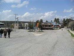
Uzuncaburç is a town in Mersin Province, Turkey.
Geography
Uzuncaburç is in the rural area of Silifke district which is a part of Mersin Province. It is located in the valleys of Toros Mountains at the north of Silifke with an altitude of 1,200 m (3,900 ft). The coordinates of the mid town are 36°35′N 33°56′E / 36.583°N 33.933°E. The highway distance to Silifke is 30 km (19 mi) and to Mersin is 111 km (69 mi). The population was 1502 as of 2012.[1]
History

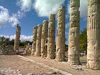
Uzuncaburç is situated next to ruins of the ancient city Olba and the name of the town Uzuncaburç (after 1973) means Tall bastion referring to the ruins. Uzuncaburç was declared township in 1992.[2]
Economy
Main crops are cereals and chickpea. There are also some vineyards. The secondary economic activity is sheep and goat breeding. Although touristic potential is great at the present tourism plays no important role in the economy of the town.
References
- ↑ TurksatArchived September 27, 2013, at the Wayback Machine.
- ↑ Mayor’s page (Turkish)