City Park (Budapest)
The City Park (Hungarian: Városliget; German: Stadtwäldchen) is a public park close to the centre of Budapest, Hungary. It is a 0.9-by-0.6-mile (1,400 by 970 m) rectangle, with an area of 302 acres (1.2 km2),[1] located in District XIV of Budapest. Its main entrance is at Heroes' Square (Hősök tere), one of Hungary's World Heritage sites.
 |
|
Name
The area was formerly called Ökör-dűlő, meaning "Oxmeadow". The first mention of the name comes from 1241 in the archaic form, Ukurföld. In the 18th century the area was called Ochsenried in German. Around 1800 the official name was changed to Batthyány-erdő (Batthyány Forest) after its tenants, the Batthyány family. The first trees and planified walkways were established in 1751 and after the public park was created in the first decades of the 19th century the present-day name, Városliget (and its German version, Stadtwäldchen, lit.: "little city forest") was accepted and it became one of the first public parks in the world.
History
The City Park was the main venue of the 1896 millennium celebrations of Hungary, by which time Andrássy Avenue, Millennium Underground and the Grand Boulevard were built.
Sports
The park hosted motorsport events in the 1950s.
Main sights
City Park includes the following sights:[2]
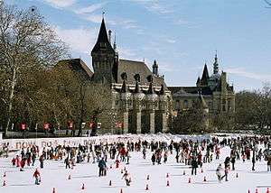
- Vajdahunyad Castle, opened in 1896
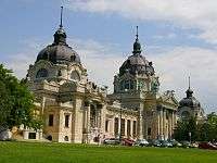
- Széchenyi thermal bath
- Budapest Zoo, including the Elephant House
- Municipal Circus, opened in 1891
- Amusement Park
- The roller coaster, Hullámvasút, built in 1922 after the plans of Ervin Dragon, is 17 m in height and travels 980 m in five minutes. It is one of the ten remaining side friction roller coasters in the world, and is an ACE Coaster Classic.[3]
- Gundel Restaurant, opened in 1894
- Budapest Circus Building[4]
See also
- People's Park (Népliget)
- Margaret Island (Margitsziget)
References
- ↑ "City Park, Budapest". aviewoncities.com. Retrieved 17 January 2014.
- ↑ "City Park". Budapest.com. Retrieved 27 March 2016.
- ↑ ACE Coaster Classic Awards
- ↑ "Budapest Circus". Youtube. Retrieved 4 October 2016.
- ↑ Youtue, Budapest Circus Loin Act
- ↑ budapestagent.com, Budapest Circus
External links
| Wikimedia Commons has media related to City Park (Budapest). |
Coordinates: 47°30′50″N 19°05′05″E / 47.51389°N 19.08472°E