Rákosmente
| Budapest XVII. - Rákosmente | ||
|---|---|---|
| District | ||
| ||
 | ||
| Country | Hungary | |
| Region | Central Hungary | |
| County | Budapest | |
| Government | ||
| • Mayor | Levente Riz (Fidesz-KDNP) | |
| Area | ||
| • Total | 54.83 km2 (21.17 sq mi) | |
| Population | ||
| • Total | 80,000 | |
| • Density | 1,525/km2 (3,950/sq mi) | |
| Website | http://www.rakosmente.hu | |
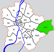
Rákosmente is the 17th district of Budapest, being the easternmost district and being the district with the largest area (54.83 km2). Rákosmente was created by uniting four villages in 1950, and annexing them to Budapest. These villages were:
- Rákoskeresztúr
- Rákoscsaba
- Rákosliget
- Rákoshegy
All these villages included the name of the little stream Rákos.
Neighbourhoods
The names of the neighbourhoods in Rákosmente come from the names of the original villages, adding the newly built neighbourhoods as well:

- Régiakadémiatelep (1930's)
- Rákoskeresztúr (13th century)
- Madárdomb (1984)
- Akadémiaújtelep (1950's)
- Rákosliget (1896)
- Rákoscsaba-Újtelep (1925)
- Rákoscsaba (11th century)
- Rákoskert (1933)
- Rákoshegy (1892)
Location
Rákosmente with its area of 54.83 km2, is more than 25 times larger than the smallest district; Erzsébetváros "Elisabethtown" (7th). Rákosmente is bordered by the 16th district to the northwest, by the 10th district to the west, by the 18th district to the southwest, by Ecser and Maglód to the southeast, by Pécel to the east and by Nagytarcsa to the northeast. The height from the sea level of some points of the district is same as the pitch of Gellért Hill.
Coordinates: 47°28′49″N 19°16′00″E / 47.4803°N 19.2667°E
|  | |