Virginia State Route 110
| ||||
|---|---|---|---|---|
| Jefferson Davis Highway | ||||
 | ||||
| Route information | ||||
| Maintained by VDOT | ||||
| Length: | 2.41 mi[1] (3.88 km) | |||
| Existed: | 1964 – present | |||
| Major junctions | ||||
| South end: |
| |||
|
| ||||
| North end: |
| |||
| Location | ||||
| Counties: | Arlington | |||
| Highway system | ||||
| ||||

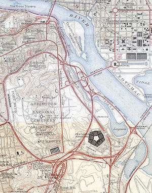
State Route 110 (SR 110) is a primary state highway in the U.S. state of Virginia. Known as the Jefferson Davis Highway, the state highway runs 2.41 miles (3.88 km) from U.S. Route 1 (US 1) and Interstate 395 (I-395) in Crystal City north to I-66 in Rosslyn within Arlington County. SR 110 is a four- to six-lane freeway that parallels the Potomac River, providing a connection between several of Arlington's urban villages. The state highway also provides access to the Pentagon, which is the headquarters of the United States Department of Defense, the grounds of Arlington National Cemetery, and SR 27, an east–west freeway between the Pentagon and the cemetery. SR 110 is a part of the National Highway System for its entire length.[2]
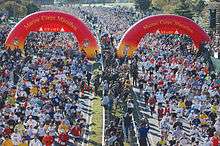
SR 110 is a part of the Pentagon road network, a network of freeways and surface roads built concurrent with the construction of the Pentagon in the early 1940s. The state highway received its numerical designation in 1964 when maintenance responsibility was transferred to the Virginia Department of Transportation. SR 110's most significant changes in routing were relocation of the highway in Rosslyn to tie into I-66 in the 1980s and relocation of the freeway at the Pentagon to provide a larger security buffer for the building after the September 11 attacks. The highway is sometimes closed for large events held at or around the Pentagon, including the Marine Corps Marathon.[3]
Route description
_at_the_junction_with_U.S._Route_1_and_Interstate_395_(Shirley_Highway)_in_Crystal_City%2C_Arlington_County%2C_Virginia.jpg)
SR 110 begins at a partial interchange with US 1 (the southern continuation of the Jefferson Davis Highway) in Crystal City where US 1 joins I-395 to cross the 14th Street Bridge into Washington; the interchange allows access to and from US 1 in the direction of Alexandria. Immediately to the north, the state highway has a partial interchange with I-395 (Henry G. Shirley Memorial Highway) that allows access from southbound SR 110 to northbound I-395 and US 1 and from southbound I-395 to northbound SR 110. The southbound exit ramp also includes a ramp for Army–Navy Drive, one of the main streets of Pentagon City. North of I-395, SR 110 heads north with six lanes immediately to the east of the Pentagon reservation. The southbound freeway has ramps to and from the Pentagon South Parking area, which serves as the main and visitor entrance to the Department of Defense headquarters. SR 110 passes under a pair of pedestrian bridges from Pentagon parking areas on between Boundary Channel Drive, which parallels the freeway, and the Boundary Channel's Pentagon Lagoon. SR 110 has a southbound exit to and entrance from the Pentagon Mall Terrace and River Terrace areas before the highway leaves the vicinity of the Pentagon by passing under SR 27 (Washington Boulevard). The partial interchange between the highways allows access from eastbound SR 27 to northbound SR 110 and from southbound SR 110 to westbound SR 27, which leads to southbound I-395 and SR 244 (Columbia Pike).[1][4]
North of SR 27, the freeway passes between the Washington Metro's Blue Line on the east and the grounds of Arlington National Cemetery to the west. SR 110 has a northbound exit to and southbound entrance from Memorial Drive, which is the main entrance to the national cemetery and also leads to the Arlington Memorial Bridge to Washington and the George Washington Memorial Parkway. SR 110 continues north with four lanes and has its sole at-grade intersection at Marshall Drive, which leads to the Marine Corps War Memorial, also known as the Iwo Jima Memorial, and the Netherlands Carillon. The highway leaves the cemetery for the urban village of Rosslyn, where the highway reaches its northern terminus. SR 110 passes under US 50 with no access then has a northbound exit and southbound entrance for Wilson Boulevard, one of the main streets of Rosslyn. Immediately to the north, the highway ends at a partial interchange with I-66 allowing access to and from the direction of Falls Church. Westbound I-66 leads to Dulles International Airport and Front Royal.[1][4]
History
The road was constructed as a part of the Pentagon Road network during World War II. Those roads were transferred to the Virginia Department of Highways on December 17, 1964 and assigned the number SR 110. At this time, the north end was reconfigured to accommodate the construction to the Theodore Roosevelt Bridge in 1964 over the Potomac River and the re-routing of Arlington Ridge Road. As a result, the north end of SR 110 was shifted west toward the prior bridge that carried US 50 over Arlington Ridge Road. SR 110 then proceeded north on the Arlington Ridge Road right-of-way, under the new bridges that carried the approaches to the Roosevelt Bridge reaching Wilson Boulevard. The road extended north to merge with the future I-66 at the Virginia end of the Roosevelt Bridge. Until the 1980s, this extension ended with the exit and entrance ramps to Lee Highway at Lynn Street. However, when I-66 was completed, this stub was extended so that SR 110 had full access to westbound I-66. One block of the historic Arlington Ridge Road was left to act as a frontage road between Wilson Boulevard and 15th Street North.
Following the September 11 attacks, SR 110 was closed to trucks and tour buses due to its proximity to the Pentagon. Police checkpoints were staffed around the clock to enforce this restriction. In September 2002, a contract was awarded to reroute SR 110 to increase the standoff distance between vehicles and the Pentagon. The project, called the Pentagon Secure Bypass,[5] was completed in 2004. SR 110 was shifted eastward in a long arc to maintain a buffer distance from the Pentagon and a two-lane bridge to provide access to the Pentagon North parking lot and two pedestrian bridges were built over the new route. These and related security improvements cost $35 million (equivalent to $44 million in 2016[6]) and were completed in October 2004.[7][8]
Exit list
The entire route is in Arlington County. All exits are unnumbered.
| Location | mi[1][9] | km | Destinations | Notes | |
|---|---|---|---|---|---|
| Crystal City | 0.00 | 0.00 | US 1 receives Jefferson Davis Highway naming | ||
| 0.20 | 0.32 | Exit 8B on I-395; southbound exit and northbound entrance | |||
| The Pentagon | 0.30 | 0.48 | Metro Facility (buses only) | Southbound access to Pentagon Transit Center | |
| 0.90 | 1.45 | Pentagon River Terrace / Mall Terrace | No northbound exit | ||
| Arlington Cemetery | 1.12 | 1.80 | Southbound exit and northbound entrance | ||
| 1.70 | 2.74 | Arlington Cemetery / Memorial Bridge – Washington | Northbound exit and southbound entrance | ||
| 1.90 | 3.06 | Marshall Drive – Netherlands Carillon, Iwo Jima Memorial, Fort Myer | At-grade intersection; no northbound entrance | ||
| Rosslyn | 2.30 | 3.70 | Wilson Boulevard – Rosslyn | Northbound exit and southbound entrance | |
| 2.41 | 3.88 | Exit 75 on I-66 | |||
| 1.000 mi = 1.609 km; 1.000 km = 0.621 mi | |||||
References
- 1 2 3 4 "2010 Traffic Data". Virginia Department of Transportation. 2010. Retrieved 2011-10-25.
- ↑ National Highway System: Washington, DC-MD-VA (Virginia) (PDF) (Map). Federal Highway Administration. 2009-11-13. Retrieved 2011-10-25.
- ↑ "Traffic Alert: Marine Corps Marathon 2010 Road Closures". Arlington County. October 20, 2010. Retrieved November 28, 2010.
- 1 2 Google (2011-10-25). "Virginia State Route 110" (Map). Google Maps. Google. Retrieved 2011-10-25.
- ↑ Construction Begins on Pentagon Secure Bypass
- ↑ Federal Reserve Bank of Minneapolis Community Development Project. "Consumer Price Index (estimate) 1800–". Federal Reserve Bank of Minneapolis. Retrieved October 21, 2016.
- ↑ Vogel, Steve (2007). The Pentagon: A History. New York: Random House. p. 473. ISBN 978-0-8129-7325-9.
- ↑ "Pentagon Renovation & Construction Program Office Project Information". Department of Defense. Retrieved November 28, 2010.
- ↑ Google (October 6, 2016). "Virginia State Route 110" (Map). Google Maps. Google. Retrieved October 6, 2016.