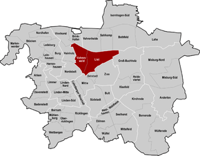
Vahrenwald-List
| Map | |
|---|---|
 | |
| Basic Data | |
| District | Vahrenwald-List (2) |
| Area | 8.23 km² |
| Inhabitants | 67,620 |
| Population density | 8,216 inh/km² |
| Postcodes | 30161, 30163, 30165, 30177, 30655 |
| Quarters |
|
| Website | hannover.de |
| Politics | |
| District mayor | Irma Walkling-Stehmann (SPD) |
| District council (21 seats) | SPD: 8, Grüne: 6, CDU: 4, Piraten: 1, Linke: 1, FDP: 1 |
Vahrenwald-List is the second district of Hanover. With 69,438 inhabitants it is the most populous district of the city consisting of the quarters Vahrenwald (24,699 inh.) and List (44,739 inh.) (all data from 2015). Since 2011, the SPD politician Irma Walkling-Stehmann holds the district mayor office.
Demographics
| Year | Population | Building |
|---|---|---|
| 1304 | 4 | |
| 1689 | 180 | 26 |
| 1823 | 286 | 38 |
| 1859 | 574 | 73 |
| 1891 | 3.200 | |
| 2011 | 43.584 | |
| 2015 | 44.739 |
Coordinates: 52°23′55″N 9°44′57″E / 52.3986°N 9.7492°E
This article is issued from Wikipedia - version of the 9/10/2016. The text is available under the Creative Commons Attribution/Share Alike but additional terms may apply for the media files.