Vailulu'u
| Vailulu'u | |
|---|---|
|
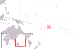
Location of American Samoa | |
| Summit depth | 590 metres (1,940 ft) |
| Height | 4,200 m (13,800 ft) |
| Location | |
| Location | South Pacific Ocean |
| Coordinates | 14°12′54″S 169°3′30″W / 14.21500°S 169.05833°WCoordinates: 14°12′54″S 169°3′30″W / 14.21500°S 169.05833°W |
| Country | United States |
| History | |
| Discovery date | 1975 |
Vailulu'u is a volcanic seamount discovered by geophysicist Rockne Johnson in the Samoa Islands on October 18, 1975.[1] The finding of an active, undersea, hotspot volcano is significant for scientists studying the Earth's fundamental processes.[2]
In size and appearance, Vaululu'u resembles Mount Fuji and ranges more than 33 km across the ocean floor at its base.[2] It rises 4200 m from the sea floor to a depth of 590 m. It is located roughly one-third of the way between Ta'u and Rose islands at the eastern end of the Samoa hotspot chain. The hotspot chain includes American Samoa and the Independent State of Samoa and extends west to the islands of Uvea or Wallis Island (Wallis and Futuna) and Niulakita (Tuvalu).[3]
The basaltic seamount is considered to mark the current location of the Samoa hotspot. The summit of Vailulu'u contains a 2 km wide, 400 m deep oval-shaped caldera. Two principal rift zones extend east and west from the summit, parallel to the trend of the Samoan hotspot. A third less prominent rift extends southeast of the summit.
The rift zones and escarpments produced by mass wasting phenomena give the sea mount a star-shaped pattern. On July 10, 1973, explosions from Vailulu'u were recorded by SOFAR (hydrophone records of underwater acoustic signals). An earthquake swarm in 1995 may have been related to an eruption from the seamount. Turbid water above the summit shows evidence of ongoing hydrothermal plume activity.
Evidence released in 2006 suggests that Vailulu'u may breach the surface of the ocean and officially become an island during this century.[4]
The name Vailulu'u comes from a Samoan story related to the sacred sprinkling of rain associated with gatherings for the Tui Manu'a paramount chiefs of Manu'a Island. The name came from an American Samoa student Taulealo Vaofusi, the winner of a naming competition.[2]
Nafanua
Nafanua is an active underwater volcanic cone that has been growing inside the summit crater of Vailulu'u since 2001. In 2005, it was 300 m tall, but still 708 m below sea level.[5] It is best known as the site of 'Eel City,' a hydrothermal vent biological community consisting mainly of synaphobranchid eels Dysommina rugosa (rather than the usual invertebrates).[6]
Around the base of Nafanua has formed a "Moat of Death" - a toxic zone formed by fluids emanating from Nafanua.[7] The ground here is covered with carcasses of dead fish, squids, and crustaceans.
Gallery
 The summit of Nafanua is covered with thick microbial mats, indicative of low-temperature venting
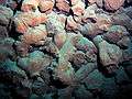 Broken pillow lavas, colored red by iron oxide, inside Vailulu'u crater.
 An octopus living on the western summit of Vailulu'u
 Swimming elasipod sea cucumber, Paleopatides sp., photographed off the northern shore of Tau Island, Vailulu'u Expedition 2005
See also
- Nafanua, a war goddess in Samoan mythology.
References
- ↑ "Vailulu'u undersea volcano: The New Samoa" (PDF). G3, An Electronic Journal of the Earth Sciences, American Geophysical Union. Research Letter, Vol. 1. Paper number 2000GC000108. 8 December 2000. ISSN 1525-2027. Archived from the original (PDF) on April 17, 2007. Retrieved 2 December 2009.
|first1=missing|last1=in Authors list (help) - 1 2 3 Lippsett, Laurence (3 September 2009). "Voyage to Vailulu'u". Woods Hole Oceanographic Institution. Retrieved 2 December 2009.
- ↑ Samoan Hotspot Trail at the Wayback Machine (archived December 23, 2010)
- ↑ Foxnews.com Emerging Ocean Volcano, Retrieved 30 August 2007
- ↑ Staudigel, H. et al. (2006) Vailulu’u Seamount, Samoa: Life and death on an active submarine volcano, Proceedings of the National Academy of Sciences, volume 103 Number 17, pages 6448 to 6453, Retrieved 30 August 2007
- ↑ Astrobiology Magazine: Extremes of Eel City Retrieved 30 August 2007
- ↑ "Vailulu'u Eel City and Moat of Death". Wondermondo.
- "Vailulu'u". Global Volcanism Program. Smithsonian Institution. Retrieved 2009-04-29.
External links
- NOAA Ocean Explorer Vailulu'u 2005 Expedition, Retrieved 30 August 2007
- Vailulu'u web site, information about the Vailulu'u seamount