Val Ferret
Val Ferret is the name of the two separate valleys, departing from the Col Ferret on the border between Italy and Switzerland, on the southern and eastern sides of the Mont Blanc Massif. The Swiss valley drains northeastwards towards Orsières and on into the Rhône basin; whereas the Italian valley drains southwestwards towards Courmayeur and on into the Po basin.
The two valleys are connected by a mountain footpath through Col Ferret which forms part of the 170 kilometres (110 mi) circular Tour du Mont Blanc route. Access to Col Ferret is forbidden for private motor vehicles, on both sides.
Swiss Val Ferret
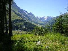
The Swiss Val Ferret is a valley on the southern side of Rhône valley in the canton of Valais in Switzerland. It lies between the Mont Blanc Massif and the Pennine Alps, with the river La Dranse de Ferret running down the length of the valley from its source to La Dranse river.
Geography

The valley starts at the Col Ferret (2490 m) on the Italian border. It is surrounded by high mountains, especially on the west side (Mont Dolent, Tour Noir and other summits of the Mont Blanc Massif).
The main villages of the Val Ferret are (from up to down): Ferret, L'A Neuve, La Fouly, Prayon, Praz de Fort, Issert and Som la Proz, all belonging to the municipality of Orsières. Altogether, the valley had approximately 700 inhabitants as at 2008[1]).
Italian Val Ferret
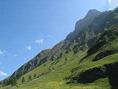
The Italian Val Ferret is the first left-side valley of Val d'Aosta, just south of the Mont Blanc Massif.
Geography
From Col Ferret (Swiss border), the valley runs down, beneath the Pré de Bar glacier and the towering Grandes Jorasses peaks. The stream running through the valley is the Dora di Ferret (French: Doire de Ferret), which, near La Palud (in front of the Italian Mont Blanc Tunnel exit), joins the Dora di Veny (French: Doire de Veny) flowing down from Val Veny to form the Dora Baltea, a left-hand tributary of Po.
The main villages are Arnouvaz, Planpincieux and La Palud, all in the Courmayeur municipality.
Tourism
The valleys are mostly frequented by hikers on the route of the Tour du Mont Blanc. Many excursions are possible from the villages, such as: Cabane de l'A Neuve from L'A Neuve or Cabane de Saleina from Praz de Fort or Cabane du Trient above the Trient Glacier.
References
| Wikimedia Commons has media related to Val Ferret (Switzerland). |
| Wikimedia Commons has media related to Val Ferret (Aosta Valley). |
Coordinates: 45°56′34.97″N 7°05′25.81″E / 45.9430472°N 7.0905028°E